-
Hello, please take a minute to check out our awesome content, contributed by the wonderful members of our community. We hope you'll add your own thoughts and opinions by making a free account!
You are using an out of date browser. It may not display this or other websites correctly.
You should upgrade or use an alternative browser.
You should upgrade or use an alternative browser.
Severe 3/1-4 SEVERE WEATHER
- Thread starter SD
- Start date
Downeastnc
Member
RIP windshields

Man you’re not kidding!

Sent from my iPhone using Tapatalk
WEATHERBOYROY
Member
That cell near Sherman Tx is a bad lookin dude ....cuttin east of NE
Discussing tomorrows threat the afternoon RAP, HRRR, 3kNAM all come back with a little more storm signature showing anf atmophere rocking in AL and GA... interesting to monitor all about that storm development right now
Attachments
NoSnowJoe
Member
Just watched a tornado form on Brad Arnold's feed on Ryan Hall Y'all on YouTube. Ryan just uploaded the video to his Twitter.
Brent
Member
Don't see this wording much
Wind gusts tomorrow from the 3k
View attachment 030223.mp4
View attachment 030223.mp4
Shaggy
Member
Interesting if it verifiesWind gusts tomorrow from the 3k
View attachment 133858
Fountainguy97
Member
Plenty of low topped supers on HRRR for tmrw. Tmrw may sneak up as one of the biggest days of this event.
Today is mostly linear in nature but tmrw we have an abundance of cellular structure.


Today is mostly linear in nature but tmrw we have an abundance of cellular structure.
That's what I've been watching if the warm mid layer erodes around parts of AL and GA then these storms will get nasty the limiting factors of storm production seems to be giving away past few runs today. There will be cells down in AL/GA and if the limiting factors now at this point are weaker then forecast or cool gonna be some strong stormsPlenty of low topped supers on HRRR for tmrw. Tmrw may sneak up as one of the biggest days of this event.
Today is mostly linear in nature but tmrw we have an abundance of cellular structure.
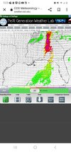
View attachment 133861View attachment 133862View attachment 133863
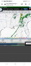
Seeing agreement across multiple models including NAM 3K for PDS TOR near Athens GA tomorrow between 4-5pm.
NAM 3k:

GFS:

HRRR:

NAM 3k:
GFS:
HRRR:
Interesting Jog south on the latest outlook. Models are showing a little more support for storm conditions further south developing pretty quickly
Shaggy
Member
@SD mhx upping their wind game even without storms.Wind gusts tomorrow from the 3k
View attachment 133858
there should still be a very shallow
layer of mixing that occurs, tapping into the lower end of the
strong LLJ. This will especially be the case for any location
that can warm and/or hold in the upper 60s. This combined with
a tightening pressure gradient ahead of the cold front should
support a period of strong winds areawide, with widespread 40-50
mph gusts plausible. Should that shallow layer of mixing end up
a little deeper, wind gusts would follow suite.
FFC with a long and informative write up I wouldnt be shocked if we see another adjustment to the risk area a little more south and west into Alabama covering a large area at least in the enhanced risk area.
Area Forecast Discussion
National Weather Service Peachtree City GA
512 AM EST Fri Mar 3 2023
...Morning Area Forecast Discussion...
.SHORT TERM...
(Today through Saturday)
Issued at 408 AM EST Fri Mar 3 2023
Overview:
Over the last 24 hours, trends have shown an increase in severe
potential for both an environmental wind threat and the threat for
severe thunderstorms this afternoon. Due to these increasing trends,
a High Warning is now in place for portions of the far northwest and
far north central Georgia to accompany the pre-existing Wind
Advisory for the remainder of the forecast area; both hazard products
are in place from 7am through 11pm, however High Wind criteria in
the Warning area is expected in the 12-5pm time frame. Additionally,
The Enhanced Risk (3 out of 5 risk level) within the Day 1
Convective Outlook has been expanded to include portions of NW
Georgia due primarily to a damaging thunderstorm wind threat, with
tornadoes, which have conditional potential to be strong and long-
track, being the secondary storm hazard for this afternoon.
Analysis:
A sharp but deep shortwave trough will be lifting from the ArkLaTex
region this morning to the Great Lakes by this evening. An extremely
quick progression with divergent flow downstream of the shortwave
and a 110+ mph jet streak at 500 hPa aiding the progression of the
system. An accompanied surface low pressure is located in South
Central Arkansas at the time of this writing with a marginally
severe squall line through central Louisiana and a warm front
through the Mid-Mississippi River Valley where prolonged rainfall
has developed a cold pool-propagated sub-severe squall line with
training cells all along the central Mississippi River. This surface
low pressure is forecast to continue pushing into the Midwest by
late this afternoon, with the HREF now resolving a non-occluded low
pressure system in S Indiana around 20 UTC this afternoon with a
central pressure of 980hPa. This is significant in two ways, first
this low is deeper than previously forecasted and begins to occlude
and weaken much later than originally forecasted as well; both of
these factors increase the severe thunderstorm threat for our area
this afternoon. A cold front is forecast to push into far NW Georgia
at the time as well with a wave of showers and thunderstorms. Storm
mode is yet to be determined with CAMs resolving anywhere from a
QLCS to semi-discrete cells along the front, with pre-frontal
showers and storms also a possibility throughout the afternoon.
The prefrontal environment will be ripe with parameters for strong
environmental winds and ingredients capable of producing severe
thunderstorms. Winds aloft indicate that at the 1 km/850 hPa level,
a low-level jet with 70+ kt wind speeds will be present, with a
pressure gradient of approximately 14 hPa from the NW corner of the
forecast area to the SE corner; both of these factors are also
enhancements compared to analysis conducted yesterday morning. For
these reasons, the High Wind Warning was introduced with afternoon,
prefrontal wind gusts increasing by about 5 mph from previously
forecast with forecast wind gusts up to 40-50 mph possible ahead of
the cold front in far north and northwest GA due to the closer
proximity to the well-formed parent low, the strong pressure
gradient, and potential momentum transfer of winds aloft due to
boundary layer mixing and downdrafts in prefrontal showers.
As for the severe thunderstorm threat, several small changes in
parameters and ingredients have elevated the severe potential this
afternoon. As discussed earlier, the parent low is now forecast to
be stronger, more mature, and is slowing down which places the
timing of storms during peak heating hours. The stronger low will
also advect higher dewpoints (mid 60s) and PWATs (1.5+ inches) into
the forecast area ahead of the storms. Increased moisture will also
help boost surface-based instability to around 1000 J/kg ahead of
the storms, with models resolving stronger storm updrafts as a
result. Shear, both in terms of speed and direction, is really
impressive, with 0-1 km shear and SRH expected to be around 50+ kts
and 300-500 m2/s2, respectfully, across North Georgia this
afternoon, which will elevate the potential for rotating supercells
this afternoon.
With all that in mind, the severe outlook for in North Georgia
remains conditional with several inhibiting factors, though several
of these factors has slightly diminished over the last 24 hours.
First, models are still struggling to resolve deep, convective
storms along the frontal zone. While PWATs have increased slightly,
dry air remains aloft at 500 hPa and above. This dry air will make
it difficult for deep updrafts to sustain themselves and will make
it harder for storms to realize their rotational potential. However,
drier air aloft is a double-edged sword as it will also promote
evaporational cooling within the storms which could form stronger
downdrafts more capable of transferring the extremely strong, upper-
level winds to the ground. Additionally, CAPE profiles remain long
and skinny with suboptimal lapse rates in the mid-levels, and this
could result in less aggressive updrafts that take longer to harness
the environmental shear. This delay may allow storms to be sheared
off more quickly, before deep rotation can form within the storms.
This is one reason why Updraft Helicities remain limited in our
convective storm-resolving models, but if storms can hang on long
enough to form a strong rotating updraft, in may persist for a
prolonged period of time and being produce tornadoes which have the
potential of being strong. Additionally, models are still resolving
some prefrontal showers, but look less likely to develop upstream of
the airflow into the line of potentually severe thunderstorms.
Careful attention will be needed for these threats throughout the
day, and we encourage all to have plans ready if they find themselves
in Convective Watches and Warnings throughout the day. While there
is some bust potential in our area (more likely for the tornado
threat than the severe wind threat), potential also remains for
dangerous situations if storms become tornadic. Please stay weather
aware throughout the afternoon. After the cold front passes,
temperatures will drop down overnight into the 40s and mid 50s, with
temperatures rebounding into the mid 60s and mid 70s on Saturday
under clear skies and light NW winds.
campamy
Member
Something fun to wake up and see this morning.

rburrel2
Member
Surprised the Tornado probabilities are so low on SPC this morning. Most of GA/SC is only in the 2% area. Could go either way, but you'd think the potential warrants a little higher probs than that.
Darklordsuperstorm
Member
Sounds like BMX is going to wait for additional sounding data at 12z.
Will be assessing the need to adjust timing on our threat graphic
to show a slower arrival time for west Central Alabama, and a
slower exit time in the east this afternoon. Instability/CAPE and
wind shear parameters are all supportive of strong to severe
storms and tornadoes. The limiting factors will be the presence
and strength of a warm nose around 700mb, and how quickly low
level warming can erode that cap. Low level warming will be
impacted by persistent cloud cover and spotty showers that are
expected to continue through the morning. The surface low will
continue to rapidly strengthen to our north, which will promote
strong winds across the area. Wind/shear values could be so strong
as to prevent sustained updrafts for thunderstorms, limiting
storm coverage and/or strength. If trends later this morning show
sustained updrafts and erosion of the cap, adjustments to the
threat area could be possible. Hope to have a better handle on how
the airmass over Central Alabama is changing with the 12Z BMX
sounding.
- Joined
- Jan 5, 2017
- Messages
- 3,809
- Reaction score
- 6,066
000
FXUS64 KBMX 031517
AFDBMX
Area Forecast Discussion
National Weather Service Birmingham AL
917 AM CST Fri Mar 3 2023
...New MESOSCALE UPDATE...
.MESOSCALE UPDATE FOR THE ONGOING SEVERE WEATHER THREAT...
Issued at 917 AM CST FRI MAR 3 2023
Mesoscale update.
The atmospheric conditions will be quite unusual today as a
powerful shortwave moves from the Lower Mississippi Valley to the
Ohio Valley. Extremely strong wind fields will accompany this
system throughout the column as a surface low deepens to around
978 mb near Paducah at noon today. The warmth and quality of
moisture already in place across Alabama would normally point to a
tornado outbreak. However, there is one significantly negative
ingredient today which makes this setup so unique, warm advection
at 600 mb. It is not often that high severe weather parameters are
wasted in Alabama, especially in the presence of height and
pressure falls. However, it appears that nearly all pre-frontal
development will be restricted by this warm layer. Healthy
updrafts should be confined along the cold front where a QLCS is
currently being observed in eastern Mississippi. The QLCS is
quickly approaching the AL/MS state line and will cross into our
northwestern counties by 10 AM. As this moves across our forecast
area, the main impacts should be across our northern two rows of
counties, closer in proximity to the upper-level support and
slightly cooler mid-level temperatures. With strong wind fields in
place, these storms may be rather efficient at producing wind
gusts of 60-70 mph. A couple of line-embedded tornadoes are also
possible. Farther south, the mid-level warm layer will become
increasingly prohibitive to updraft development, so much so, that
dewpoints of 70F will not be sufficient for deep convection.
It appears the warm nose aloft is still there over most of AL and probably GA, too. I don't think we are getting 70F dews, so this will limit updrafts and the strong upper level wind fields will tear apart anything taking it's sweet time lifting from the lower levels.
Cbmatt2408
Member
That really is a good thing, because the STPs on the HRRR are over 6 in a lot of areas. If storms broke through today, they could have been extremely intense in central and north GA and AL.
000
FXUS64 KBMX 031517
AFDBMX
Area Forecast Discussion
National Weather Service Birmingham AL
917 AM CST Fri Mar 3 2023
...New MESOSCALE UPDATE...
.MESOSCALE UPDATE FOR THE ONGOING SEVERE WEATHER THREAT...
Issued at 917 AM CST FRI MAR 3 2023
Mesoscale update.
The atmospheric conditions will be quite unusual today as a
powerful shortwave moves from the Lower Mississippi Valley to the
Ohio Valley. Extremely strong wind fields will accompany this
system throughout the column as a surface low deepens to around
978 mb near Paducah at noon today. The warmth and quality of
moisture already in place across Alabama would normally point to a
tornado outbreak. However, there is one significantly negative
ingredient today which makes this setup so unique, warm advection
at 600 mb. It is not often that high severe weather parameters are
wasted in Alabama, especially in the presence of height and
pressure falls. However, it appears that nearly all pre-frontal
development will be restricted by this warm layer. Healthy
updrafts should be confined along the cold front where a QLCS is
currently being observed in eastern Mississippi. The QLCS is
quickly approaching the AL/MS state line and will cross into our
northwestern counties by 10 AM. As this moves across our forecast
area, the main impacts should be across our northern two rows of
counties, closer in proximity to the upper-level support and
slightly cooler mid-level temperatures. With strong wind fields in
place, these storms may be rather efficient at producing wind
gusts of 60-70 mph. A couple of line-embedded tornadoes are also
possible. Farther south, the mid-level warm layer will become
increasingly prohibitive to updraft development, so much so, that
dewpoints of 70F will not be sufficient for deep convection.
It appears the warm nose aloft is still there over most of AL and probably GA, too. I don't think we are getting 70F dews, so this will limit updrafts and the strong upper level wind fields will tear apart anything taking it's sweet time lifting from the lower levels.
ForsythSnow
Moderator
With that said I wonder why the SPC felt the need to expand the enhanced area again which now covers more areas.That really is a good thing, because the STPs on the HRRR are over 6 in a lot of areas. If storms broke through today, they could have been extremely intense in central and north GA and AL.

Sun is out now in extreme NW Georgia.
Cbmatt2408
Member
With that said I wonder why the SPC felt the need to expand the enhanced area again which now covers more areas.

This is the first run that has shown supercells south of Atlanta. I would say everyone from Columbus, GA north in the West GA/East AL corridor need to be on alert today. If something like this one above forms, the atmosphere is spinning violently. The sun is also breaking through north of LaGrange now and were about to top 70.
Snow_chaser
Member
Sun has popped out here in NW Paulding county, don’t need no spinners, we on the 11 yr anniversary of tornadoes hitting Paulding county and my house got damage then.
I don't see much for NC unless the sun comes out. We usually need the sun to light the match for storms.
Drizzle Snizzle
Member
Observed tornado near Paducah.
- Joined
- Jan 5, 2017
- Messages
- 3,809
- Reaction score
- 6,066
The line is moving pretty efficiently through AL at the moment. Nothing very severe with it, though. You can see a graphical representation of the HRRR's severe parameters by looking at the simulated satellite/radar. Notice that the storms south of Atlanta are not very tall. This is the main problem with getting severe today. The updrafts just can't be maintained very well with the warm air in the mid-levels and high upper level winds. I bet if the wind shear was a category lower, they could, though.
Incredibly high helicity values on NAM 3k at 4pm in Athens, GA


iGRXY
Member
Winds already picking up here and it looks like storms are going to hold together longer and getting this broken up line of storms is worrisome in a highly favorable environment.
LovingGulfLows
Member
- Joined
- Jan 5, 2017
- Messages
- 1,499
- Reaction score
- 4,100
Incredibly high helicity values on NAM 3k at 4pm in Athens, GA
View attachment 133922
View attachment 133924
View attachment 133925
STP values peak at about 5 in my backyard later this afternoon. Don’t like that.
Ron Burgundy
Member
Not good. But at least everyone will be awake. Seems like these lines always come though here at 4amSTP values peak at about 5 in my backyard later this afternoon. Don’t like that.
Decatur AL had a wind gust of 77mph. Huntsville AL airport hit 69mph.
Ron Burgundy
Member

Really nasty tornado-warned line heading toward Chattanooga
Ron Burgundy
Member
TOG far NE AL
MamaJen
Member
Here in far SE Bartow Co, we just had some showers pass through and now the sun is peaking out. Dew point is up 2 points (now 67 at my nearest weather station) in the last hour, too. Definitely has that unsettled feel.
iGRXY
Member
WInd really piking up and temps are really going north. 65 now.