Shaggy
Member
It just came off the coast we will have plenty of runs to sort through over the next 10-12 days
It just came off the coast we will have plenty of runs to sort through over the next 10-12 days


Too far north already0Z UKMET for what may be first AEW behind 97L:
NEW TROPICAL CYCLONE FORECAST TO DEVELOP AFTER 150 HOURS
FORECAST POSITION AT T+150 : 16.0N 49.7W
LEAD CENTRAL MAXIMUM WIND
VERIFYING TIME TIME POSITION PRESSURE (MB) SPEED (KNOTS)
-------------- ---- -------- ------------- -------------
1200UTC 17.08.2025 156 17.0N 51.1W 1010 27
0000UTC 18.08.2025 168 18.4N 53.9W 1011 24
NewSouthwestern Gulf:
A tropical wave over the northwestern Caribbean Sea is producing
disorganized showers and thunderstorms extending across eastern
Honduras, northeastern Nicaragua and adjacent marine areas. This
system is forecast to move west-northwestward and cross the Yucatan
Peninsula on Wednesday with no significant increase in
organization. Some development of this system is possible after it
emerges across the southwestern Gulf beginning on Thursday while
the system moves to the west-northwest or northwest at 10 to 15 mph.
* Formation chance through 48 hours...low...10 percent.
* Formation chance through 7 days...low...20 percent.
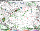
The end of the EC-AIFS reminds me of Helene.View attachment 174189
The EPS has the same potential storm in its forecasts. It had this feature going out to sea as a minimal hurricane later in the forecast period.12Z UK: for several runs has had this after Erin:
NEW TROPICAL CYCLONE FORECAST TO DEVELOP AFTER 156 HOURS
FORECAST POSITION AT T+156 : 15.9N 24.3W
LEAD CENTRAL MAXIMUM WIND
VERIFYING TIME TIME POSITION PRESSURE (MB) SPEED (KNOTS)
-------------- ---- -------- ------------- -------------
0000UTC 20.08.2025 156 15.9N 24.3W 1010 28
1200UTC 20.08.2025 168 15.7N 28.1W 1009 32
12Z UK: for several runs has had this after Erin:
NEW TROPICAL CYCLONE FORECAST TO DEVELOP AFTER 156 HOURS
FORECAST POSITION AT T+156 : 15.9N 24.3W
LEAD CENTRAL MAXIMUM WIND
VERIFYING TIME TIME POSITION PRESSURE (MB) SPEED (KNOTS)
-------------- ---- -------- ------------- -------------
0000UTC 20.08.2025 156 15.9N 24.3W 1010 28
1200UTC 20.08.2025 168 15.7N 28.1W 1009 32
Euro and GFS have dropped anything after Erin.Followup to above:
0Z UKMET has a similarly placed TD following Erin vs the 12Z run:
NEW TROPICAL CYCLONE FORECAST TO DEVELOP AFTER 156 HOURS
FORECAST POSITION AT T+156 : 15.9N 28.1W
LEAD CENTRAL MAXIMUM WIND
VERIFYING TIME TIME POSITION PRESSURE (MB) SPEED (KNOTS)
-------------- ---- -------- ------------- -------------
1200UTC 20.08.2025 156 15.9N 28.1W 1010 33
0000UTC 21.08.2025 168 15.8N 30.4W 1009 29
Watch the Bay of Campeche for a possible TC late this week as they often overperform: these percentages look too low
1. Southwestern Gulf:
A tropical wave near the east coast of the Yucatan Peninsula is
producing disorganized showers and thunderstorms this morning. This
disturbance is forecast to move west-northwestward and cross the
Yucatan Peninsula today with no significant increase in
organization. Some development of this system is possible after it
emerges across the southwestern Gulf beginning on Thursday while the
system moves to the west-northwest or northwest at 10 to 15 mph.
* Formation chance through 48 hours...low...10 percent.
* Formation chance through 7 days...low...20 percent.
Follow-up: The SW Gulf system, now Invest 98L, is rather convectively active this morning. This area often overperforms and won’t be inland til late tomorrow. It’s currently still only at 20%.
MJO climo to keep in mind regarding Invest 98L:
Hurricanes since 1975 in Jul-Sep that hit S or C coast of TX in MJO phase 2:
-Hanna of 2020
-Harvey of 2017
-Claudette of 2003
-Bret of 1999
All S or C coast of TX H landfalls Jul-Sep since 1975 by MJO phase:
-1: Allen 1980
-2: Hanna, Harvey, Claudette, Bret
-3: Beryl 2024, Dolly 2008
-4-8: none
So, of the 7 Hs to landfall on S or C TX Jul-Sep since 1975, 4 (57%) hit during phase 2 and 6 (86%) hit during either phase 2 or 3!
The MJO is in phase 2 today and is progged to likely be in phase 2 tomorrow though phase 3 is a slight possibility. Just some climo for thought.
