Henry2326
Member
Seeing the tropical threats die down warms my heart. I think the US is good and doesn't need anymore hurricanes.
you post globals but not ens?

And NHC agrees with them all.
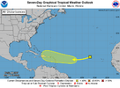
View attachment 153217
NWS National Hurricane Center Miami FL
800 AM EDT Sun Oct 13 2024
For the North Atlantic...Caribbean Sea and the Gulf of Mexico:
1. Eastern Tropical Atlantic (AL94):
Showers and thunderstorms have diminished again in associated with
an area of low pressure located a few hundred miles west of the Cabo
Verde Islands. While the system is currently embedded in an
environment that is not favorable for development over the next
couple of days, the system is forecast to move generally westward to
west-southwestward across the tropical Atlantic, where environmental
conditions could become more favorable for gradual development in
the central Tropical Atlantic by the mid to latter part of this
week.
* Formation chance through 48 hours...low...10 percent.
* Formation chance through 7 days...low...30 percent.
Appears to be the year of first in a very long time.It is this nondevelopment well east that’s actually making it potentially more dangerous to land area in the W basin. The only way this late in the year something moving through the MDR has on record (back to 1851) hit land in the W basin is nondevelopment until near the longitude of the Lesser Antilles or further W.
Appears to be the year of first in a very long time.

Another exceptionally unusual thing is that many models have this system tracking WSW to one degree or another from near the Lesser Antilles to near the SE or Central American coast. Unusual at any time of year much less this deep into October!It is this nondevelopment well east that’s actually making it potentially more dangerous to land area in the W basin. The only way this late in the year something moving through the MDR has on record (back to 1851) hit land in the W basin is nondevelopment until near the longitude of the Lesser Antilles or further W.
