ForsythSnow
Moderator
It appears so. 12Z on top, 0Z bottom.Anyone have Euro access? I'm curious if it trended a tick colder like the other modeling so far today?


It appears so. 12Z on top, 0Z bottom.Anyone have Euro access? I'm curious if it trended a tick colder like the other modeling so far today?
Thanks! That's a 1-3 degree drop around the edges. I believe the Euro usually runs a little warm at the surface in these types of setups too. Still quite a few model cycles left. I wonder if they will slowly cool until go time???It appears so. 12Z on top, 0Z bottom.
... and then you have possible severe later in the week ...Special Weather Statement for this area.

Do not need any trees downor power out.... and then you have possible severe later in the week ...
Thanks ... just don't let anyone tell you that this year's flu shot is worth a hoot ...Do not need any trees downor power out.
Hope you are feeling better
Did not get shot, caught some bug but not flu.Thanks ... just don't let anyone tell you that this year's flu shot is worth a hoot ...
Some of the meanest severe I've seen up your way was near Neel Gap ... holy cow can a SW wind whip in there ...
Back to bed; up for an hour and am afraid to say more lest it be garbage ...
We weren't man. We don't get appreciable winter weather anymore. Can't even get ice anymore. Which no one really wants in the first place.For those wondering, CAE is not part of this. Here is a snippet from KCAE, infact:
"Have
indicated all rain in the current forecast given latest
guidance. Models have continued to trend warmer with lows
Saturday night ranging from the low 30s along and north of I-20
to the upper 30s in the southern CSRA."
We weren't man. We don't get appreciable winter weather anymore. Can't even get ice anymore. Which no one really wants in the first place.

Nope, pretty sad. Very sad.Yep and now modeling is getting warmer and less Gulf tracks to support anything for us. Most of the systems are late bloomers, crap half-phasers, and inland runners through 384 hours of the GFS. Not even a fantasy storm!
Losing power on Super Bowl Sunday will not make a lot of people happy with an ice storm
I want to see how the wedge erodes Sunday. 3k nam at one point has rdu at 50 gso at 39. Big bust potential around here. If we get drizzle and rain Sunday morning I have a hard time seeing 50 at rduFor Cen NC folks I noticed on the 18z 3k NAM it's sneaking in some moisture off the Atlantic to get some patchy light zr a little sooner and a smidge further east. Nothing significant but something to monitor
Sent from my SM-G920V using Tapatalk
It doesn't do any good to have 300+ hour GFS snowstorms, because they NEVER materialize! So just torch runs and apps rubbers, are great, because they give no false hope!Yep and now modeling is getting warmer and less Gulf tracks to support anything for us. Most of the systems are late bloomers, crap half-phasers, and inland runners through 384 hours of the GFS. Not even a fantasy storm!

Per the NAM, there isn't any CAPE, no updraft helicity, and no sign of severe WX. The line only lasts a couple hours outside the temp change and quickly falls apart as well. It may look severe to you, but I see nothing outside a strong wind gust.The 3km NAM wants to develop an embedded squall line along the edge of the very sharp CAD boundary late on Sunday. Can't entirely rule out a threat for severe weather in this case especially those along and just east of the boundary. There will be an area of significantly enhanced storm relative helicity and baroclinicity wherever the SE edge of the CAD dome sets up
View attachment 3739
The wind gusts along the line aren't really all that far off from severe limits, it wouldn't take much given the extreme baroclinicity along the edge of the CAD dome and the winds aloft if the convection is intense enough. I've seen many situations like this occasionally produce embedded, rain-wrapped and brief spin up tornadoes, especially near the Triad which is why there's a secondary max in tornado density near Winston-Salem and near/just west of Charlotte as Brandon Vincent of NWS RAH discussed several years ago during the storm spotter training session on campus at NCSU. Many of those tornadoes in the central-western piedmont formed along CAD boundaries like this one.Per the NAM, there isn't any CAPE, no updraft helicity, and no sign of severe WX. The line only lasts a couple hours outside the temp change and quickly falls apart as well. It may look severe to you, but I see nothing outside a strong wind gust.


Per the NAM, there isn't any CAPE, no updraft helicity, and no sign of severe WX. The line only lasts a couple hours outside the temp change and quickly falls apart as well. It may look severe to you, but I see nothing outside a strong wind gust.

Absolutely, don't recall dates/specifics but I've seen many times severe right along the CAD and a few tornadoes in those situations, usually nothing widespread but it certainly has happened a number of times. Models usually miss it too if I recall correctly. The wedge can be as fickle for NWP as ull to be honestThe wind gusts along the line aren't really all that far off from severe limits, it wouldn't take much given the extreme baroclinicity along the edge of the CAD dome and the winds aloft if the convection is intense enough. I've seen many situations like this occasionally produce embedded, rain-wrapped and brief spin up tornadoes, especially near the Triad which is why there's a secondary max in tornado density near Winston-Salem and near/just west of Charlotte as Brandon Vincent of NWS RAH discussed several years ago during the storm spotter training session on campus at NCSU. Many of those tornadoes in the central-western piedmont formed along CAD boundaries like this one.
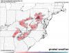
View attachment 3740
View attachment 3741
Absolutely, don't recall dates/specifics but I've seen many times severe right along the CAD and a few tornadoes in those situations, usually nothing widespread but it certainly has happened a number of times. Models usually miss it too if I recall correctly. The wedge can be as fickle for NWP as ull to be honest


Going to be a real battle from the triad to the foot of the apps to get above freezing tomorrow. Models are starting really hit on the idea of the in situ wedge locking in. You can see the wind barbs on the 3k nam flipping from E to north and a narrow ridge axis in that area. I think the area from yadkinville to Morganton might over perform possibly even east of there. But the lack of a consistent dry feed should allow of latent heat release from the freezing rain to push these areas to 32 33 by mid afternoon.Winter Weather Advisory implemented for the Triad. Freezing Rain expected from 6 to 9AM Sunday morning before warming to plain rain. Really worried it will go longer than that because these CAD events almost always do. Right now just a light glaze is anticipated but I am not so sure
Yeah I agree, seen this so many times here, forecast calls for a changeover much quicker than it turns out almost every time. It is kind of the reverse warm nose which happens during most snows and hardly ever is forecastGoing to be a real battle from the triad to the foot of the apps to get above freezing tomorrow. Models are starting really hit on the idea of the in situ wedge locking in. You can see the wind barbs on the 3k nam flipping from E to north and a narrow ridge axis in that area. I think the area from yadkinville to Morganton might over perform possibly even east of there. But the lack of a consistent dry feed should allow of latent heat release from the freezing rain to push these areas to 32 33 by mid afternoon.
Sent from my SM-G955U using Tapatalk

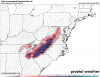
I honestly don't get the whole Forsyth county ice hole, but it's showing up a lot, so it's going to verify. However, if I wake up to freezing rain and icing, or I get sleet instead, it's a bust. It would also be a bust if it's way colder or way warmer tonight.This would be pretty much worst case scenario. Hopefully, it's wrong.View attachment 3757
Ugh those are the worst. I believe it was in 2010 where I got 2.5 inches of snow one evening that then switched to rain and washed it all away. If I remember correctly it switched back to snow and dumped 2 more inches at the end. It was one of the wackier storms I can recall. I just remember thinking if the whole system had stayed snow I would have had the rare 6 plus inch accumulating snow.this would be the cruel punchline for this winter in CHA if the front end thump over-performs and gives us an inch or two of snow only to be washed away hours later by the warm nose moving in with rain.