Ummmm, it's getting icy here Bowersville-Lavonia area
-
Hello, please take a minute to check out our awesome content, contributed by the wonderful members of our community. We hope you'll add your own thoughts and opinions by making a free account!
You are using an out of date browser. It may not display this or other websites correctly.
You should upgrade or use an alternative browser.
You should upgrade or use an alternative browser.
Wintry 2/3-2/4 Mixed Bag NC, SC, NE GA
- Thread starter Blue_Ridge_Escarpment
- Start date
ForsythSnow
Moderator
Cars outside have ice on them and the trees appear to be glistening slightly.
ForsythSnow
Moderator
Appears to be a tenth of an inch of ice. Only on cars, plant, and trees.
Cad Wedge NC
Member
Moderate freezing rain (had some sleet earlier) and 30 degrees. Everything is glazed.

Nomanslandva
Member
Temp went from 33 to 28 with mod snow. We'll see how long it takes for the warm nose to get us and then see how long it take to scour out the wedge. I fired the generator up yesterday just to be sure... Anyone have the latest RGEM ice map? That seemed to be the worst case model.
ForsythSnow
Moderator
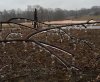
Here is where we are at with the ice. Pine trees have are sagging a little also.
JHS
Member
Went from rain at 7:30 over to freezing rain now. Temps still dropping slowly here.
Nomanslandva
Member
Pingers with a few flakes now.
I would think that if temps remain below freezing, accrual would be more affected by the duration of the event rather than the intensity. There is probably an optimal intensity for maximum ice accrual for a specific temp below freezing....I.e. too little precip, you don’t reach max accrual, while too much precip is a waste.Consider this possible more simplistic reason heavier ZR may tend to accrete on branches at a lower rate: If for no other reason, a higher % of heavier rain likely drips off branches too quickly for it to have time to freeze on those branches. I'll exaggerate to make a point: What if somebody were to rapidly pour a bucket (representing extremely heavy ZR) of supercooled water on a branch? Wouldn't almost all of it go right to the ground below the branch? Compare that to pouring it very slowly over said branch. Wouldn't more of it accrete?
Very light intensity will result in a higher percentage of precipitation to accrue, while intensity that is too high will result in wasted precip.
My guess is that in the end, once the optimal intensity for a temp is reached, accrual rates from that point forward will be mostly affected by the duration of the event and not fall off as intensity increases....as long as the temp remains below freezing. I just guessing here, so I could be wrong.
gawxnative
Member
That is true in part to increase in surface area to accrue, (i.e. increase in diameter if ice crusted pine needles)I would think that if temps remain below freezing, accrual would be more affected by the duration of the event rather than the intensity. There is probably an optimal intensity for maximum ice accrual for a specific temp below freezing....I.e. too little precip, you don’t reach max accrual, while too much precip is a waste.
Very light intensity will result in a higher percentage of precipitation to accrue, while intensity that is too high will result in wasted precip.
My guess is that in the end, once the optimal intensity for a temp is reached, accrual rates from that point forward will be mostly affected by the duration of the event and not fall off as intensity increases....as long as the temp remains below freezing. I just guessing here, so I could be wrong.
Light rain 35/31 yuck. Hrrr has it near 60 here this afternoon. Good luck
Sent from my SM-G955U using Tapatalk
Sent from my SM-G955U using Tapatalk
That’s a good point. I was trying to simplify it so I left that out. But you’re exactly right. Ice accrual on an object leads to more surface area which leads to more accrual on the object and so on.That is true in part to increase in surface area to accrue, (i.e. increase in diameter if ice crusted pine needles)
Still 31° in NE Georgia. ZR continues
SimeonNC
Member
Some very light glazing on some of the furniture on the backyard patio.
I would think that if temps remain below freezing, accrual would be more affected by the duration of the event rather than the intensity. There is probably an optimal intensity for maximum ice accrual for a specific temp below freezing....I.e. too little precip, you don’t reach max accrual, while too much precip is a waste.
Very light intensity will result in a higher percentage of precipitation to accrue, while intensity that is too high will result in wasted precip.
My guess is that in the end, once the optimal intensity for a temp is reached, accrual rates from that point forward will be mostly affected by the duration of the event and not fall off as intensity increases....as long as the temp remains below freezing. I just guessing here, so I could be wrong.
This all makes sense. One thing I want to add: large build ups of ice in trees can occur when ground temps are at or just barely below 32 based on Atlanta area major ZR history as opposed to requiring 31 or colder even though a higher % would typically accrete at 31 vs 32.
Webberweather53
Meteorologist
As liquid mass turns into ice, it releases heat. Basically think of it as a solid changing to a liquid, the energy "trasnfer" has to give off some sort of warmth. Anything in motion will give off some form of heat.
As the liquid mass freezes on contact, the energy expunged creates a tiny little pocket of heat. As the rates become heavier, more heat is released and eventually the ground level comes above freezing.
Lighter ZR is letting less heat off as fast, because the droplets are smaller or the rate of precipitation as a whole, is lighter. From what I have seen, the bigger ice storms that have occurred in heavy precipitation scenarios were when the surface was too cold (26-28F) to be overcome by the liquid to solid change, and the end result being destructive ice accretion.
At least this process is what I was taught in my reading.
@Webberweather53 will hopefully, have a better response to this process.
Yes, you both touched on key processes in freezing rain that warm near-surface temperatures. Obviously latent heat of fusion w/ the change of phase from liquid to solid is one of the most easily recognizable. The reference Larry made to water falling through a warmer layer of air and bringing that warmer air aloft to the surface is a real process and is more formerly known as sensible heat transfer, it also occurs in other precipitation types as well, not exclusively ZR. It's a process most NWP models have a difficult time resolving or just don't account for at all. You're also right in that the kinetic energy of the drops when it comes in contact w/ a surface will also release heat as a byproduct. Longwave radiation from the ground, heating from viscous flow around the near-surface objects, and even some modest shortwave solar radiation also comes into play in warming the surface.
There was a nice paper by Sanders and Barjenbruch in 2016 detailing some of these processes and Ice-Liquid-Ratios (ILRs) & development of models/forecasting techniques to account for this in real-time.
https://journals.ametsoc.org/doi/pdf/10.1175/WAF-D-15-0118.1
SimeonNC
Member
The WWA has been extended until 12 for my area.
Webberweather53
Meteorologist
Light rain 35/31 yuck. Hrrr has it near 60 here this afternoon. Good luck
Sent from my SM-G955U using Tapatalk
Yeah, the HRRR is already too warm here in Raleigh on the 13z run at hour 1.