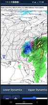
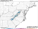
• Hello, please take a minute to check out our awesome content, contributed by the wonderful members of our community. We hope you'll add your own thoughts and opinions by making a free account!

Wintry 2/11-2/12 ULL Magic or More Cold Rain

Tonight's NAM 500mb image over the Carolinas and Georgia at hr84 is the 'spittin image' of the 24hr NAM from the March 1, 2009 run...

1st Image: Tonight's NAM
2nd Image: NAM from 2009

GvJyNQg.gif


FgKM59Q.gif
While the placement is exactly the same regarding the ULL, the big difference is the 09 system had a lot more northern stream interaction. Hopefully, it works out in the end, but it'll be nerve-wracking watching it pour rain while tracking the cold-core low coming in.
 
Tonight's NAM 500mb image over the Carolinas and Georgia at hr84 is the 'spittin image' of the 24hr NAM from the March 1, 2009 run...

1st Image: Tonight's NAM
2nd Image: NAM from 2009

GvJyNQg.gif


FgKM59Q.gif

The key piece that's missing from this setup that we had in Mar 2009 is that healthy northern stream shortwave over southern Ontario & Quebec. The northern stream wave gives Mar 2009's upper low a legit source of (nearby) cold air to tap into, we unfortunately won't have that luxury :/
 
While the placement is exactly the same regarding the ULL, the big difference is the 09 system had a lot more northern stream interaction. Hopefully, it works out in the end, but it'll be nerve-wracking watching it pour rain while tracking the cold-core low coming in.
Hear ya, but that's why I mentioned the comparison being just over the Carolinas and Georgia. But it's still the same type of setup where it's a rainstorm that flips to snow on the NW side of a trailing closed contour upper low that is moving fairly slowly
 
Hear ya, but that's why I mentioned the comparison being just over the Carolinas and Georgia. But it's still the same type of setup where it's a rainstorm that flips to snow on the NW side of a trailing closed contour upper low that is moving fairly slowly
What I remember most about that 09 storm is I wound up right under its pivot point as it began its move to the NE. This one, unlike some of our board-wide WAA snows, is truly every man for himself lol.

Another thing we have going for us down here is the timing looks good rather than the middle of the day in early March.
I’d much rather get a snow in Mid Jan than Mid Feb, but it’s certainly better than early March.
 
If the upper low on this model frame was actually ~600 nautical miles east over Atlanta, GA instead of Dallas, TX, this weekend would be a classic snowy upper low setup for the Carolinas. But alas, we can't have nice things.

The low being further east here would have given us a much better deep-layer continental polar cold air feed to work with ahead of the mid-level ridge over the Upper Midwest & Manitoba.

Screen Shot 2023-02-08 at 8.36.55 PM.png


Everything about this set up is right, except the upper low is in the wrong place at the wrong time to take the most advantage of this cold air feed. That one change to the circulation pattern is all it would take to go from a cold rain to heavy, wet, crippling snow outside the mountains. Unfortunately, that scenario seems pretty unlikely atm given we're about 2-3 days out from the valid time on the attached model image.


Screen Shot 2023-02-08 at 5.47.28 AM.png
 
Back
Top