-
Hello, please take a minute to check out our awesome content, contributed by the wonderful members of our community. We hope you'll add your own thoughts and opinions by making a free account!
You are using an out of date browser. It may not display this or other websites correctly.
You should upgrade or use an alternative browser.
You should upgrade or use an alternative browser.
12/8/2025 Event - Repeat of Last Week?
- Thread starter packfan98
- Start date
Those flakes have made it to the Coliseum area in Greensboro!Big flakes mixing in now NW Guilford
Yeah, we don’t have much moisture to work with as it is, so wasting a lot of it (all of it?) on rain or “mood flakes” that don’t stick because it’s several degrees above freezing and during the daytime isn’t great.Wind chill below 32 in Durham right now but real temp is 38… definitely wishing we didn’t have so many degrees to drop til freezing here
the hrrr is interesting for your neck of the woods. it's rather aggressive with coastal enhancement. something to watch for you... i've always thought cyclogenesis is the hardest piece to nail down since convection plays a part (it helps ramp up low level vorticity). north east NC's x-factorBring it with you to the double R
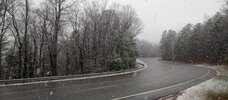
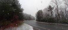
Just rode up 181 and chicken feather's were coming down. Jonas Ridge had close to 3in. I stopped at 2700ft brown mountain overlook and took these pics.Nice light rain falling here in Morganton.
Attachments
Snow at airport GSO. Just started to flip
Maybe we can get a back end squallthe hrrr is interesting for your neck of the woods. it's rather aggressive with coastal enhancement. something to watch for you... i've always thought cyclogenesis is the hardest piece to nail down since convection plays a part (it helps ramp up low level vorticity). north east NC's x-factor


lexxnchloe
Member
Can you post it? Thanksthe hrrr is interesting for your neck of the woods. it's rather aggressive with coastal enhancement. something to watch for you... i've always thought cyclogenesis is the hardest piece to nail down since convection plays a part (it helps ramp up low level vorticity). north east NC's x-factor

LukeBarrette
im north of 90% of people on here so yeah
Meteorology Student
Member
2024 Supporter
2017-2023 Supporter
It’s possible, the stuff up in WV is way over performing. So could be a banding issue.i'm a little surprised you're both hurting for moisture and having temp issues at elevation. you think there's a mesoscale rainshadow deal/banding in WV robbing your moisture?
Brown Mountain Overlook 2700ft. 4 miles south of Jonas Ridge, NC Burke County

I think when it's all said and done I'll be a little too far west for that, if in fact any coastal enhancement materializesthe hrrr is interesting for your neck of the woods. it's rather aggressive with coastal enhancement. something to watch for you... i've always thought cyclogenesis is the hardest piece to nail down since convection plays a part (it helps ramp up low level vorticity). north east NC's x-factor
Webberweather53
Meteorologist
Coastal enhancement should materialize
NWG_WX14
Member
Flipping back and forth between big flakes and rain. Temp is down to 34
Webberweather53
Meteorologist
Yeah the 12z gso sounding showed wet bulb zero heights of about 600m, only needed to fall 150m or so to see some wet snow
Bigedd09
Member
12zFV3 really gets things going in the piedmont in the next hour or so. Probably not right but fun to look at
Sent from my iPhone using Tapatalk
Sent from my iPhone using Tapatalk
Idk it looks like it's starting in Greensboro12zFV3 really gets things going in the piedmont in the next hour or so. Probably not right but fun to look at
Sent from my iPhone using Tapatalk
Sent from my SM-S156V using Tapatalk
lcpdk
Member
Light snow in Kernersville Eastern Forsyth County.
39/36 and some sun starting to break thru in portions of the upstate. y'all enjoy this one for me up in NC. hrrrrrr taking tarboro to pound town tonight

Tsappfrog20
Member
Latest Hrrr has trended snowier for the triangle/northeast NC
Sent from my iPhone using Tapatalk
Sent from my iPhone using Tapatalk
Scooter
Member
About 50/50 mix down to 34 at the house.
LukeBarrette
im north of 90% of people on here so yeah
Meteorology Student
Member
2024 Supporter
2017-2023 Supporter
Somehow my temp has increased to 33 again. Not sure how
temps are so marginal that even the high country is seeing melting right now
same with the 12z nam 3k. of course, it is nowcasting time - but still good to see these last minute shifts on the short rangesLatest Hrrr has trended snowier for the triangle/northeast NC
Sent from my iPhone using Tapatalk

Moderate all snow at GSO now.
all snow, no stick. 34.1, wet bulb 33.1
LukeBarrette
im north of 90% of people on here so yeah
Meteorology Student
Member
2024 Supporter
2017-2023 Supporter
Yeah if we had adequate temps in Bburg we would have 2+ right now but we have less than an inchtemps are so marginal that even the high country is seeing melting right now
Tsappfrog20
Member
Sent from my iPhone using Tapatalk
Idk it looks like it's starting in Greensboro
Sent from my SM-S156V using Tapatalk
That’s a
 ’ed post from Tim.
 Loving the snow videos and reports fellas. Y’all enjoy this one
Webberweather53
Meteorologist
We should see a good burst of snow over the Northern Coastal Plain of NC later today as low-level warm advection intersects with DPVA aloft from the approaching mid level vort max.
Also, note the weak 700mb warm advection with temps around or just below -10C, which is near the base of the snow growth layer. This too will favor greater snowfall rates


Also, note the weak 700mb warm advection with temps around or just below -10C, which is near the base of the snow growth layer. This too will favor greater snowfall rates
Sounds like the cold is having a tough time settling in towards the western portion of NC but I believe we’ll see it show up for the eastern counties as moisture arrives. Somebody is going to get some decent surprise snow I think
Snowing @Frosty’slandofmisfitweather 35°
Sent from my iPhone using Tapatalk
Sent from my iPhone using Tapatalk

Nomanslandva
Member
I'v been stuck at 33. Franklin county getting the rates!Somehow my temp has increased to 33 again. Not sure how