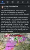
I agree. Along with the number of power outages… there could be millions of people without power with colder air coming in on the backside of this stormThe line of storms already coming in 75 to 85mph winds reported on SPC storm reports. I think the biggest story will be this becoming an extreme derecho event. Tornadoes yes, but the sheer widespread wind damage will likely be top story on this.
-
Hello, please take a minute to check out our awesome content, contributed by the wonderful members of our community. We hope you'll add your own thoughts and opinions by making a free account!
You are using an out of date browser. It may not display this or other websites correctly.
You should upgrade or use an alternative browser.
You should upgrade or use an alternative browser.
12/15/21 Midwest Severe
- Thread starter SD
- Start date
BufordWX
Member
Severe weather on one side and snow squall warnings on the other. Quite the storm.
Downeastnc
Member
On the cold note, news in Waterloo saying low of 29 tonight! Kind of a big drop from high of 73I agree. Along with the number of power outages… there could be millions of people without power with colder air coming in on the backside of this storm
Whole line is severe warned! ?per our local mets
BufordWX
Member
Definitely an impressive line. I’m surprised with how many tornado warnings there are as well.Whole line is severe warned! ?per our local mets

Prestige Worldwide
Member
Darklordsuperstorm
Member
Dewpoint Dan
Member
One thing is for sure. The central US has much more interesting weather than the southeast.Definitely a "December to remember"
Sitting in Waterloo, screen door open, 67 degrees, line bowing out just to my West, good times
Semis blown over on Interstate 80, farm buildings flattened, local met said the storms are moving at 70 mph
Line is strengthening 
Just said line is moving at 100 mph now! ?????????
Darklordsuperstorm
Member
Downeastnc
Member
Jesus
Yeah I mean thats just ridiculous and pretty unprecedented, like literally the only time you would normally see anything remotely like that is in a landfalling hurricane....
Jesus
A positive thing to take away from that is that the winds aren't mixing down to the ground as much as they were earlier. Only 70 MPH gusts in that wording.
Dud here! Gusts to 25, looks like wind stopped as storm got here! 3 flashes of lightning , a clap of thunder, next! 
Stormsfury
Member
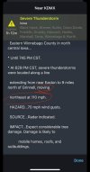
Heavy damage reports coming out of Extreme Southern MN per SPC and a possible tornado. Damage to a bank and other structures
Heavy damage reports coming out of Extreme Southern MN per SPC and a possible tornado. Damage to a bank and other structures
Confirmed tornado in Plainview, MN.
B
Brick Tamland
Guest
Definitely a "December to remember"
And I think we're going to see this extreme weather more and more often.
Brent
Member
Confirmed tornado in Plainview, MN.
First tornado ever in Minnesota in December apparently
BufordWX
Member
Stormsfury
Member
Extreme impressive considering it just beat out the Iowa Derecho record...
Shaggy
Member
Not to mention a bunch of 70-74 mph readings that were just short of that 75mph mark. Add in a few baseball sized hail and one softball sized hail event and you have a record breaking December storm outbreak.Extreme impressive considering it just beat out the Iowa Derecho record...
I'd be surprised if there was another December on record with 2 back-to-back historic severe weather outbreaks.
Darklordsuperstorm
Member
Definitely. Especially considering that it's hard enough to see it in the spring. This has been an unprecedented December. The thread title for the month "December to Remember " was certainly fitting.I'd be surprised if there was another December on record with 2 back-to-back historic severe weather outbreaks.
olhausen
Member
Maybe one year it will be a December to remember for the white stuff.Definitely. Especially considering that it's hard enough to see it in the spring. This has been an unprecedented December. The thread title for the month "December to Remember " was certainly fitting.
They have already happened in 2010 and 2017 here.Maybe one year it will be a December to remember for the white stuff.
cd2play
Member
It’s not often you here the word derecho in December!

Some new information this AM! ???
Now officially the biggest tornado outbreak since 1950 in Iowa! And to think it happened in December! I think they just added 11 more confirmed today , because yesterday the event was in 2nd place!