Day 1 Categorical

Day 1 Wind

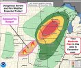
day 1 tor

Day 1 sigtor

13z HRRR with a monster line this afternoon

Day 1 Wind
day 1 tor
Day 1 sigtor
13z HRRR with a monster line this afternoon
Dude that squall line on the HRRR just looks nightmarishDay 1 Categorical
View attachment 98040
Day 1 Wind
View attachment 98041
day 1 tor
View attachment 98042
Day 1 sigtor
View attachment 98043
13z HRRR with a monster line this afternoon
View attachment 98044
Really impressiveDude that squall line on the HRRR just looks nightmarish


It’s weird, lots of low clouds and drizzle, but 65 degrees, and peeks of sunUnless there's shallow low clouds I'm not seeing, there's pretty good insolation right now over SE Nebraska and SW Ioawa

Then there is this??View attachment 98056


Was about to post, just outside Waterloo, lost the low clouds?The western 2/3rds of Iowa and much of far eastern Nebraska looks to have clear skies now.


Not very often that you see a moderate risk that far north in the middle of December. Yikes


No doubt about it! For reasons such as this:While not PDS, still pretty high end for a TOR Watch...
Unbelievable videos coming out of CO today.
If the line is moving at 55-70mph, won’t that make the already strong winds worse??The line of storms already coming in 75 to 85mph winds reported on SPC storm reports. I think the biggest story will be this becoming an extreme derecho event. Tornadoes yes, but the sheer widespread wind damage will likely be top story on this.
If the line is moving at 55-70mph, won’t that make the already strong winds worse??
Looks like there's a quite a bit of CIHN across IA.
While the line should easily break the cap, the CIHN may be the saving grace that prevents more tornadic supercells from developing ahead of the line.