WXinCanton
Member
UKMET is a N MS,AL,GA snowstorm
Pics?UKMET is a N MS,AL,GA snowstorm
 s who wishcashed this back to us. Keep it up.
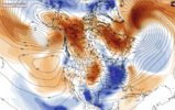
Come on #8 lolGEFS is a mix of big dogs, suppression, and some similar to GFS. I appreciate all you
View attachment 159923
Will you post earlier panel say Friday 12zGEFS is a mix of big dogs, suppression, and some similar to GFS. I appreciate all you
View attachment 159923
Oh wow. That's interesting. Wonder what the Euro shows.
I’ll take a #8 or #4Come on #8 lol
panel-19 is interesting. Looks like a precursor to a miller-B? Otherwise its west of the apps. The rest of the panels make sense as depicted in some op version or just suppressionGEFS is a mix of big dogs, suppression, and some similar to GFS. I appreciate all you
View attachment 159923
Thanks
Not only out front, but the 00z run dug it farther south. Some of the more recent runs aren’t doing that as muchView attachment 159911
Better. Would be cool to improve on it. Still wish we could get the northern energy out in front of the Baja piece like the 0z run showed last night.
I'm very intrigued that it showed that actually. It's one of the better reliable models with the Euro.UKMET is dangerous at this timeframe. If that image above verified then I would have a heart attack.
It killed -- to write this
Encourages me considering how good the EPS looked at 00z. If the Euro and/or EPS can backup 00z then its game on.I'm very intrigued that it showed that actually. It's one of the better reliable models with the Euro.

Time to buy a "Team UKMET" jersey.
UKMET
Sent from my iPhone using Tapatalk
Ehhh, For the ridge to amplify further, you'd need stronger upstream forcing—such as an intensified trough or cyclone in the Gulf of Alaska—which would enhance downstream ridging over the western U.S. This would drive higher geopotential heights, allowing the jet stream to buckle more dramatically, resulting in a deeper trough over the central and eastern U.S.I think they are undergoing the cold air to some degree


This is why the EURO AI's signal is so bullish.Ehhh, For the ridge to amplify further, you'd need stronger upstream forcing—such as an intensified trough or cyclone in the Gulf of Alaska—which would enhance downstream ridging over the western U.S. This would drive higher geopotential heights, allowing the jet stream to buckle more dramatically, resulting in a deeper trough over the central and eastern U.S.
Additionally, a robust Arctic air mass poised (which we have) over Canada would fuel cold air advection into the trough. A well-placed Greenland block or high-latitude ridge could further anchor the pattern, enhancing the ridge-trough configuration and extending the duration and intensity of the cold air intrusion into the southern U.S. This interplay between atmospheric teleconnections and mid-latitude dynamics would be the key to realizing colder temperatures farther south.
View attachment 159930
Trends are definitely good for For an all snow event for Northern Upstate850 Temps never go above 0c during the storm for our NC/SC peeps on the GEFS
Here is your GEFS


Great post grit! I feel like we are gonna see several more solutions still and after tomorrow sampling on the feature itself may go totally to crap. Hopefully not but it has the feel of dont get comfortable or confident until Thursday 12z model suite.We have a lot of tricky setups that we follow to get a winter storm, but this one at 500mb is upper echelon in terms of trying to forecast the interplay of the waves and what the end result will be between the Baja wave, the early shortwave that drops into the Baja wave that kicks it east / potentially amplifies it, the central plains trough dropping down (location, tilt, how much it phases, tilt of phasing) - and then the interplay with the NAtlantic side with 50/50 low extension back to the SW. I’d say it’s the most complicated we’ve seen since the Christmas 2010 storm, tho that one had higher to much higher boom potential
That's trending cooler for some and warmer for others.It isn’t just the AIFS trending way colder with the setup but the icon is as well View attachment 159890