carolinachaos
Member
It warms the eastern Carolinas up at the height of the precipitation. Then temps drop as the precip moves out? I know this is not gonna be the final solution, but one of the possibilities.
Sent from my iPhone using Tapatalk
Track and warm air advection. If this AIFS were to occur, it's an upstate, Northern GA and NC storm for snowIt warms the eastern Carolinas up at the height of the precipitation. Then temps drop as the precip moves out? I know this is not gonna be the final solution, but one of the possibilities.
Sent from my iPhone using Tapatalk


180 hours for 0z and 12z runs, and 120 hours for 06z and 18z runs.How far does the ICON go out? 188hrs??

We got shut out in Ooltewah.We had 10 inches in evensville tn, I have a picture somewhere with a framing square


Holy cow it’s on. This could be the one. The Neo of winter storms.
This is a rare big time and I mean big time storm potential though. Atlantic is backed up. Pretty rare opportunity to get a bigginOne thing I’m kinda glad about even in spite of the amplified ai run is that the 50/50 is staying put and has even moved southwest a little bit, and has become more wound up/strongerView attachment 158837
That 50/50 is the reason we keep getting good runs from different models producing different setups.One thing I’m kinda glad about even in spite of the amplified ai run is that the 50/50 is staying put and has even moved southwest a little bit, and has become more wound up/strongerView attachment 158837
lol, tonight has much to see stillThis is the big one till tomorrow morning. Let’s see the trends.
Yeah man. It's why I said the other day that we have the potential for a monster storm here.This is a rare big time and I mean big time storm potential though. Atlantic is backed up. Pretty rare opportunity to get a biggin
Is the snowfall totals using the standard 10:1 or is the totals calculated on forecast Kuchera ratio's?Latest weighted blend from WxBlender.. btw, if anyone would like to test out WxBlender, shoot me a DM and I'll get you access.
View attachment 158806
View attachment 158807
The especially frustrating thing is when local mets don’t seem to look at soundings when putting forecasts together. I still remember January 2022 when every local station was saying that CLT metro was about to get a major ice storm right up until about 6 hours before go time even though every sounding you pulled up was showing sleet becoming the predominant precip with very little ZR.View attachment 158811View attachment 158812I have a growing grudge for certain things, and it’s certain globals showing ZR when soundings are clearly evidently supporting IP over ZR when precip maps show ZR. It fools a lot of people and has in past events, hence why it seems like ZR events rather becomes IP dominant
Agreed with the sentiments. This is one where I think a full phase actually may be the best path here - a fresh injection of Arctic air wrapped into the storm would do wonders. I'm kind of all or nothing myself on this one - 12/26/2010 is honestly a top-10 most disappointing storms of all-time for me despite getting 6" (at RDU) because of how close it was to 3-4x that much. 6" would be a disappointment here IMO and frankly I'd rather swing huge and miss however that happens rather than end up with a partial or late phaser again. RDU hasn't had a 10" storm in over 20 years, but this is an opportunity regardless of what happens. Odds are obviously low, but they are almost always zero.Yeah man. It's why I said the other day that we have the potential for a monster storm here.
Why u giving up?I’m honestly to the point of checking out. I’ve seen how this ends too many times.

Euro AI and 18z GFS are showing a great opportunity. You sure you want to check out, now?I’m honestly to the point of checking out. I’ve seen how this ends too many times.
I gotta be honest, that image looks completely ridiculous. Was this a screenshot from an NES game? Precipitation type does not follow straight lines.View attachment 158811I have a growing grudge for certain things, and it’s certain globals showing ZR when soundings are clearly evidently supporting IP over ZR when precip maps show ZR. It fools a lot of people and has in past events, hence why it seems like ZR events rather becomes IP dominant
Banter thread. Can’t blame him at allWhy u giving up?
Euro AI and 18z GFS are showing a great opportunity. You sure you want to check out, now?

I’ll take my chances here with that look!
Fair we seen this play out many times were the mirage fades away... I will admit this one seems to be the best atmospheric condition chance we had in several years to get some legit snow stretching over parts of SE but enjoy the ride and stay in the middle lanes don't get too much 1 way or another on the end results definitely been there and did that on both sidesMy guess is the concern by him is that this is going to end up amped and too warm outside of a pretty far north GA, and NC event.
SorryBanter thread. Can’t blame him at all
Dang, you must be my first cousin! What a huge letdown 12/26/10 was after the Euro had 3 straight runs of a just biblical storm - and plenty cold. And honestly, it has never been the same since that moment on. It was THE defacto model back then in the medium range. Not that way anymore.Agreed with the sentiments. This is one where I think a full phase actually may be the best path here - a fresh injection of Arctic air wrapped into the storm would do wonders. I'm kind of all or nothing myself on this one - 12/26/2010 is honestly a top-10 most disappointing storms of all-time for me despite getting 6" (at RDU) because of how close it was to 3-4x that much. 6" would be a disappointment here IMO and frankly I'd rather swing huge and miss however that happens rather than end up with a partial or late phaser again. RDU hasn't had a 10" storm in over 20 years, but this is an opportunity regardless of what happens. Odds are obviously low, but they are almost always zero.
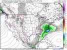
You shouldn't like them. But anyway, here is a comparison of the 12z GFS Graphcast and the 18z Euro AI. First off, these models aren't dropping down 2 NStream waves like the GFS. Rather, there is one NStream wave that drops down thru W Montana and into the Baja wave that is kicking out. They both phase the waves quite nicely.Not sure if I'm liking these amped up solutions 7 days out though

I been inadvertently trying to point this out. The big question is when%if this comes out of the sw. That line in the sand moment, whether it gets hung up or comes out, is just about to cross the 120 hour mile marker. Should see a consensus form over next 3 0z an 12z model cycles. This isnt some long range storm way out there anymore. We will know for 90% plus certainty by mid weekend if shes really coming or not. Vibe is right now, shes coming.The energy that becomes the cutoff in the SW hits the west coast in 3.5 days or so View attachment 158846