-
Hello, please take a minute to check out our awesome content, contributed by the wonderful members of our community. We hope you'll add your own thoughts and opinions by making a free account!
You are using an out of date browser. It may not display this or other websites correctly.
You should upgrade or use an alternative browser.
You should upgrade or use an alternative browser.
Wintry 1/9-12 Winter Potential Great Dane or Yorkie
- Thread starter SD
- Start date
NBAcentel
Member
When I posted that, it was after the latest run of the EURO at that time. The EURO looked horrible when David Glenn showed it. Everything worked out pretty good for us!Where are you seeing that?
GFS just gave us 5 inches
Sent from my iPhone using Tapatalk
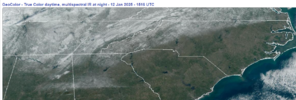
It’s almost criminal that line of heavy snow south of Atlanta didn’t extend at an angle up through SC to connect to @BIG FROSTY ranchVisible satellite from this morning showing the snow left behind from the storm.
View attachment 162932
It’s almost criminal that line of heavy snow south of Atlanta didn’t extend at an angle up through SC to connect to @BIG FROSTY ranch
Yeah, you guys got robbed. Getting a dud in the middle of a snow drought just makes it worse. But sooner or later the GSP CLT RDU peeps will get a good thump. Hopefully sooner.
Webberweather53
Meteorologist
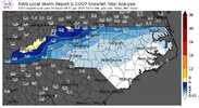
The first ice + snow map of many. Hoping I can get at least a few of these knocked out the next day or two. Might even draw up a couple maps for folks in Georgia too because of how fascinating this case is, especially in/around Atlanta. Appreciate all the snow/ice totals you all have posted, keep 'em coming.
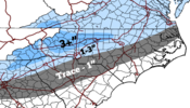
Preliminary freezing rain/ice accumulation map for NC:
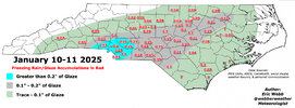
Preliminary freezing rain/ice accumulation map for NC:

coldspringsfarm
Member
I realize the next storm has everyone's attention, but does this group ever do storm post-mortems? Would love to see discussion on things like:
Best performing models at 10 day through 1 day lead times, throwing call maps under the bus, throwing forecasts from NWS offices under the bus, etc...
Best performing models at 10 day through 1 day lead times, throwing call maps under the bus, throwing forecasts from NWS offices under the bus, etc...
Brent
Member
I realize the next storm has everyone's attention, but does this group ever do storm post-mortems? Would love to see discussion on things like:
Best performing models at 10 day through 1 day lead times, throwing call maps under the bus, throwing forecasts from NWS offices under the bus, etc...
Ha I know we busted horribly here... Supposed to get a dusting and got 6 inches
I guess it makes up for the snow holes the last 2 winters when we went the opposite way
Snowflowxxl
Member
Lots of melting today but the shaded areas are hanging on very well.
NBAcentel
Member
Still have ice/sleet in a few shaded areas lol
rburrel2
Member
You gotta take your wins where you can find them. I made a little snow man in a spot that stays full shade. Hoping he can live to see another snow.Still have ice/sleet in a few shaded areas lol
BHS1975
Member
Yeah same here. Sleet has a lot more staying power than snow.Still have ice/sleet in a few shaded areas lol
coldspringsfarm
Member
Was there ever a model(run) showing closer to what you actually ended with?Ha I know we busted horribly here... Supposed to get a dusting and got 6 inches
I guess it makes up for the snow holes the last 2 winters when we went the opposite way
This part makes me irrationally happy. Just seeing it in shady spotsStill have ice/sleet in a few shaded areas lol
Too bad none of it will be left when the D10 storm on the Euro drops two feet of snow on us.This part makes me irrationally happy. Just seeing it in shady spots
I’ll believe it when I see it. Glad to have had anything this winterToo bad none of it will be left when the D10 storm on the Euro drops two feet of snow on us.
LukeBarrette
im north of 90% of people on here so yeah
Meteorology Student
Member
2024 Supporter
2017-2023 Supporter
Driving to AMS in New Orleans right now and there is still snow here in Northern Alabama. Cool storm
Darklordsuperstorm
Member
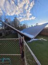
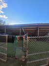 A late report from this week's storm. We actually had some damage at my job. I work at an Animal Clinic in Hoover. Our roof that covers our daycare yard actually had enough snow and ice accumulation that it completely collapsed under the weight. We discovered it in this condition when we came in Friday morning.
MBY had .51 All Frozen qpf. Predominant ptype ended up being FC, frozen concrete. Got the kids another day off tommorow.
Brent
Member
Was there ever a model(run) showing closer to what you actually ended with?
I don't think so until the final day maybe. It became obvious the band in Arkansas was trying to shift up this way. I guess we sort of had the NW trend people talk about out here
But I also know about 5 days out when I went to KC the entire GFS run had no snow here(16 days...) several runs and even showed a very similar snow hole on most of them
But yeah this storm had absolutely no hype there wasn't even a winter storm warning til it was already snowing and it ended up being our snowiest day in 14 years. Go figure
ITUSETOSNOW
Member
There is still a substantial covering in my area, I measured today it was 2.4 inches.
ITUSETOSNOW
Member
The moon reflecting off the remaining snow in my area is astounding. It looks almost like Dawn out.
Avalanche
Member
This is in Brick’s wheelhouse. He will let you know real fast the best storms come with no warning, and no storms come when there is a warningI don't think so until the final day maybe. It became obvious the band in Arkansas was trying to shift up this way. I guess we sort of had the NW trend people talk about out here
But I also know about 5 days out when I went to KC the entire GFS run had no snow here(16 days...) several runs and even showed a very similar snow hole on most of themit's why I try to tell people not to focus on the op runs because of the wild swings like that
But yeah this storm had absolutely no hype there wasn't even a winter storm warning til it was already snowing and it ended up being our snowiest day in 14 years. Go figure
Still hanging on in the shade in many spots. No class today so headed over to Eno River I imagine they’ll have some leftover as wwll
- Joined
- Jan 23, 2021
- Messages
- 4,602
- Reaction score
- 15,197
- Location
- Lebanon Township, Durham County NC
Pretty decent coverage as of this morning around us and we’re near itStill hanging on in the shade in many spots. No class today so headed over to Eno River I imagine they’ll have some leftover as wwll
Pretty decent coverage as of this morning around us and we’re near it
North facing and shady spots had plenty
A few thoughts regarding the models and trying to forecast this one...
This storm made me think about how it could be a good idea to divide your forecast thoughts on the time period before the high res models come out (Days 4+) vs. the time period when the high res models will be on the storm (Days 1-3).
In the Day 4+ period, the Euro AI was fantastic and the clear winner in my mind with how it consistently brought the various pieces together at 500mb to produce the end result of Miller A from the gulf coast to the Carolina coast (baja wave / central conus trough dropping in / partial phase / positive tilt trough).
In the end, the Euro AI was a bit too suppressed with the storm track and too cool with temperatures aloft (an issue with most of the globals), though it was actually quite good with surface temperatures east of the Apps, as it had the cold air entrenched down into SCarolina.
But whenever there is a gulf low, we have to take into account whether or not we have enough cold air to hold off the inevitable warmth that it brings with it. In this case, at days 4-6, it would have been smart to say, OK, when the high res models get a hold of this storm, what are they going to do with it? For one, we could maybe anticipate that the baja low kicking east was going to be a heat pump on its eastern flank, pumping warmth out of Mexico and into the southern plains and southeast. And although we had some decent cold air over the Mid-Atlantic and NE with some fresh snowpack, there was not good, cold high pressure to the north (which many pointed out), and forecast thicknesses were high. So, there was a built in weakness there for the warmth to climb north. And when there is a weakness, we should anticipate that the high res models are going to take advantage of it when they come into view in the Day 1-3 timeframe, especially so when the precip is driven by warm advection in absence of a good, closed low at 850mb that has a southerly track, and with good cold air to the north.
Anyway, those are just some thoughts when looking back on this storm in hindsight forecasting wise.
Wilkes County schools are closed tomorrow due to slush being froze. Lows in the teens this week. Most roads have been scraped but secondary roads are very poor esp ones that face north in the shade.
wow
Member
Catawba and Rowan are remote learning days as well. I'm pretty surprised at that. There's not much left around here.
Brent
Member
We're pretty much back to normal but there are some deep shady spots with sheets of ice still even though we hit 52 yesterday
This is really good. It is hard in the SE to keep the column cold enough for snow over a large area. It's why big snowstorms tend to stick in our memory -- they are rare. And it's why I harp so much on favorably-located high pressure of favorable strength with a cold source region. A bombing storm could do the trick too, with a cold conveyor belt and crashing heights on the backside (although a good HP feeding cold into the storm is preferable).A few thoughts regarding the models and trying to forecast this one...
This storm made me think about how it could be a good idea to divide your forecast thoughts on the time period before the high res models come out (Days 4+) vs. the time period when the high res models will be on the storm (Days 1-3).
In the Day 4+ period, the Euro AI was fantastic and the clear winner in my mind with how it consistently brought the various pieces together at 500mb to produce the end result of Miller A from the gulf coast to the Carolina coast (baja wave / central conus trough dropping in / partial phase / positive tilt trough).
In the end, the Euro AI was a bit too suppressed with the storm track and too cool with temperatures aloft (an issue with most of the globals), though it was actually quite good with surface temperatures east of the Apps, as it had the cold air entrenched down into SCarolina.
But whenever there is a gulf low, we have to take into account whether or not we have enough cold air to hold off the inevitable warmth that it brings with it. In this case, at days 4-6, it would have been smart to say, OK, when the high res models get a hold of this storm, what are they going to do with it? For one, we could maybe anticipate that the baja low kicking east was going to be a heat pump on its eastern flank, pumping warmth out of Mexico and into the southern plains and southeast. And although we had some decent cold air over the Mid-Atlantic and NE with some fresh snowpack, there was not good, cold high pressure to the north (which many pointed out), and forecast thicknesses were high. So, there was a built in weakness there for the warmth to climb north. And when there is a weakness, we should anticipate that the high res models are going to take advantage of it when they come into view in the Day 1-3 timeframe, especially so when the precip is driven by warm advection in absence of a good, closed low at 850mb that has a southerly track, and with good cold air to the north.
Anyway, those are just some thoughts when looking back on this storm in hindsight forecasting wise.
The bottom line is that we generally need to be feeding cold air in during whatever storm type you want to throw in. In many/most cases, we get everything in between the ideal and end up with a sloppy mess. The baking a cake equivalent would be a pretty looking cake that is too salty and falls all apart when you try to eat it.
packfan98
Moderator
Yeah, we are on remote learning day #3. Not ideal for learning. I'm ready to get back to my classroom.Still decent amount sn/ip in shade and this pic is from school my wife teaches in RR, they had about an inch more than me (just 8 miles north)
View attachment 163278
They actually are on regular schedule. I won't get into that but numerous schools look like that and they returned yesterday, some parents aren't happy.Yeah, we are on remote learning day #3. Not ideal for learning. I'm ready to get back to my classroom.
Last edited:
Yesterday dad dropped the ol’ “if snow stays on the ground for more than 3 days that means more is coming to visit it.”Still decent amount sn/ip in shade and this pic is from school my wife teaches in RR, they had about an inch more than me (just 8 miles north)
View attachment 163278
Yep my 81 yr old mom dropped the "it's lying around waiting for more" phrase yesterday. Lol it's comingYesterday dad dropped the ol’ “if snow stays on the ground for more than 3 days that means more is coming to visit it.”
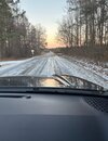
Surry County Schools closed tomorrow, Forsyth Winston Salem 2hr delay. This ice is stuck on the roads impossible to scrape.

