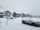
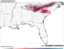
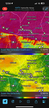
Rates must be way better. 30 miles north of you mostly sleet hereback to all heavy snow. Whew that was close
-
Hello, please take a minute to check out our awesome content, contributed by the wonderful members of our community. We hope you'll add your own thoughts and opinions by making a free account!
You are using an out of date browser. It may not display this or other websites correctly.
You should upgrade or use an alternative browser.
You should upgrade or use an alternative browser.
Wintry 1/9-12 Winter Potential Great Dane or Yorkie
- Thread starter SD
- Start date
iGRXY
Member
Ripping fatties here
Twister
Member
All Snow here around Sunset in upstate But nothing just real heavy. Again no way I see this laying down 3-4"
No snow for you
Member
- Joined
- Dec 28, 2016
- Messages
- 583
- Reaction score
- 890
Snowing pretty good next to the hosiptal Prisma but nothing sticking to the road. 30 right now
UNCSC
Member
Sleet only on business 85/i-26 Spartanburg area
First flakes at 12:37 pm
Psalm 148:8
Member
- Joined
- Dec 25, 2016
- Messages
- 344
- Reaction score
- 789
Still snowing in Young Harris!!
Stormsfury
Member
More sleet falling in Goose Creek. Amazing having a break of a couple hours and now back to sleet. Temp 33.
Congrats to all that are getting a much overdue winter storm!
Congrats to all that are getting a much overdue winter storm!
smast16
Member
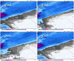
No way i'm hitting 38, when it's only 30. It'll begin sticking immediately which will help when there's little QPF.HRRR slowly giving it up with those crazy warm surface temps this afternoon.
View attachment 162463
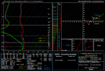
Yeah it could definitely start as a snow/sleet mix before rates increase. Going to be a back and forth affair around here (with that classic Wake County gradient from probably a dusting to 0.5" south to around 2" far north) probably.Thoughts on this starting as sleet around here? I'm starting to think those light returns will get here a bit before expected but not be snow in the light stuff
Tsappfrog20
Member
Sister in Douglasville Ga got 6 inches!!!
Sent from my iPhone using Tapatalk
Sent from my iPhone using Tapatalk
Hot off the presses from centennial campus
RAH 1240pm disco
"
One thing of note, the regional radars are showing the H925/H850
warm front progressing northward through far northern MS/AL,GA and
upstate SC, depicted by the bright band. It has been progressing
quickly from Birmingham to Huntsville in 4-5 hours. Atlanta is now
reporting rain. While this will surge northward, it will be impeded
by the rapidly developing in-situ CAD east of the Blue Ridge, and
will likely stay south and east of the region through at least
00z/tonight before starting to make a run at FAY and GSB.
"
we got a lot of work to do if -- forecast is gonna bust lol
ncweathergirl
Member
Snowing in Salisbury
GoDuke
Member
I can tell it’s been awhile because the snow looks more like the foam they call “snoap” they shoot out of cannons at Disney Springs around Christmas time. Lol
junbb1
Member
Hopefully coming my way. Very underwhelming so far. I am afraid of dry slot development and redevelopment towards Charlotte. Seen that happen in the past… hope Im wrong!Ripping fatties here
LukeBarrette
im north of 90% of people on here so yeah
Meteorology Student
Member
2024 Supporter
2017-2023 Supporter
GeorgiaGirl
Member
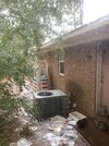
Not sure this will be visible, but I tried to take a picture of the icesicles here (pretty sure I got the spelling wrong).
It is having a hard time with sticking, so that shows I was still right to say that we’d probably just miss on a more impactful ice event, but some areas may have had 2 inches of snow/sleet here before a transition occurred. Not 100%.
I’ll try to see if my better stuff on my phone can load later.
It is having a hard time with sticking, so that shows I was still right to say that we’d probably just miss on a more impactful ice event, but some areas may have had 2 inches of snow/sleet here before a transition occurred. Not 100%.
I’ll try to see if my better stuff on my phone can load later.
Attachments
NBAcentel
Member
Just heard a couple of pingers on my window in Plaza Midwood, Charlotte
MichaelJ
Member
how we hangin @Jimmy Hypocracy
ChattaVOL
Member
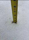
I’m just over 3” now
Sent from my iPhone using Tapatalk
In northeastern Columbia, never saw any snow but it's been consistent sleet and (freezing) rain. Definitely starting to see some ice hanging off plants. Temp has remained 30-31
- Joined
- Jan 2, 2017
- Messages
- 1,566
- Reaction score
- 4,279
Now it's pouring nickles and a few quarters
JHS
Member
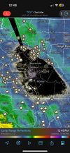
That minimum over me is real. Not 1 flake of snow and only a very little sleet here so far.Hrrr really consistent on I-85 being the cutoff between 1-2” of snow/sleet and maybe 2-4” of more snow/less sleet, notice during heavier banding on it the snow sorta crashes south a bit before changing back to IP. Someone along I-40 is gonna do really well View attachment 162473
Forevertothee
Member
Clinton busted low on snow. Flurried. Light snow lasted15 mins. Sleet/mostly freezing rain. Ice forming roof line. Few pockets of sleet on the mulch. Roads wet for now. Not often it snows south and west of here and we get zilch. Congrats to Greenwood and Saluda peeps that saw SN from that heavy front band that missed me. Bummed out.
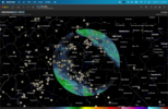
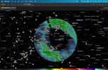
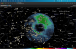
You may already know this, but others may not, but this is completely normal and happens in all of these events. The radar beam is increasing with height as it goes away from the radar, so it looks like it is snowing all around it but in reality the column is slowly moistening with height. That's why the ring will slowly close in as the column moistens downward with time.
This is why when you look at higher tilts, the ring of radar returns is closing in.
JHS
Member
Me and you are going to see a major icestorm I'm afraid. 2-4 days of no power incoming.Clinton busted low on snow. Flurried. Light now 15 mins. Sleet/mostly freezing rain. Ice forming roof line.
Wulfer
Member
Some change over appears to be happening now.
D
Deleted member 609
Guest
I doubt we get more than a trace of snow here. Probably going to start as sleet.
Still riding the line. Mostly snow. Flipping back and forth from snow to sleet snow mix. Need rates with this onehow we hangin @Jimmy Hypocracy

