buckinbronco
Member

Solid
The low needs to track across the panhandle/Valdosta and not Macon. GA gets screwed with thi
Need the low in Fla the whole time. Too close to the fire otherwise.The low needs to track across the panhandle/Valdosta and not Macon. GA gets screwed with tthis setup
Hey Grit. It’s been a while. I’m always reading in here but don’t post much anymore. Still great to read posts from people I’ve been talking to on these boards for years and have become so knowledgeable.Hello rduwx, good to see you on here!! I would say there's 2 components to it: 1) High Pressure to the north, and 2) The airmass in place over E Canada / NE / M Atl. Ideally, we have a big high, in strong damming, with a big pool of cold air to the NW, N, and NE of us. In this case, we don't have the high pressure, but we have a good (not great), cold airmass over us and to the north as the storm is moving in. So, negatives are that we don't have the high pressure, and we don't have a super cold airmass. Positives are that the airmass is pretty solid and it's in place...it's not fighting to get across the mountains. But we should always, always question temperatures along the line from Raleigh to GSP
And I have noticed UKMET continues to have the SNOW line further south between I-85 and just northwest of Columbia. It continues to keep southern parts of the Upstate like Laurens, Greenwood, and Abbeville in play. (GFS has to latest runs). We know Upstate South of 85 is getting ice, I just want the ground covered with snow before that change over.
Yes it is. The central U.S. trough doesn't dig south as much as the more amplified solutions. It starts to dig south, then heads east. This is why I'm of the opinion that it's going to be very difficult to get large totals / and keep the cold. Gotta be a trade off there unless we can pull a rabbit. Euro AI and EPS are probably the best mix of bothStill very euro-y for the ukie
It matched its 12z almost exactly.Still very euro-y for the ukie
further east you get in nc, the more these flatter solutions are better. I’m not sure there’s a scenario at this point where we amp it very much and get an all frozen event east of I-77Yes it is. The central U.S. trough doesn't dig south as much as the more amplified solutions. It starts to dig south, then heads east. This is why I'm of the opinion that it's going to be very difficult to get large totals / and keep the cold. Gotta be a trade off there unless we can pull a rabbit. Euro AI and EPS are probably the best mix of both

Meh lighter amounts, solid 1-3 across NC but this is a much weaker system then the ICON/CMC/GFS

Yeah that low transfer is something I am always leery about. I hate that phenomenon as an upstater. Would love to have a storm without a transfer and resulting dryslot.I think we are looking at a True Miller A.
We are going to start to see 8-12 swaths across a broad area from Southern Tenn to the Northern parts of Miss, Bama, & GA,
Then turn the corner and stretch up the 85 corridor in the Carolinas.
Also with that meso H setting up somewhere in the Virginias and with the path of the storm the apps may help with a lee side enhancement instead of dry slotting us!
So those totals may get higher in the Carolinas East of the apps if that low doesn't transfer!
We deserve this ladies & gentlemen East of the apps we have paid our dues.
i agree it's better at 500mb but i disagree that we're looking for more positive tilt- i think we want more negative tilt by the time the northern stream shortwave dives into the dakotas in a few days. I think it puts more of the board, especially our eastern members, in position for a bigger hit.The GFS improved a bit at 500mb - more positive tilt with the trough. As usual, baby steps with the GFS


I hear ya. If we can get more storm and keep the cold too, I’m all for it. Just playing with fire more on the southern edge when going that route. Icon accomplished both which was nice to seei agree it's better at 500mb but i disagree that we're looking for more positive tilt- i think we want more negative tilt by the time the northern stream shortwave dives into the dakotas in a few days. I think it puts more of the board, especially our eastern members, in position for a bigger hit.
The icon was the best model- wind barbs for the back of the trough around the front range/dakotas are almost purely northerlies at hour 90 at 5h
View attachment 160680
whereas with the gfs, there was a significant easterly component to these barbs
View attachment 160681
my take is that the trough on the icon, with better tilt, is able to take advantage of more northerly energy digging into it which helps bring the trough base (and everything else) south. the reason the gfs failed (relatively, for eastern folks) is that the trough was too positively tilted and too much energy got pinched off in that stupid fold in the south, which brought the best forcing (and everything else) northward. I do like your AZ-MT benchmark but I think this is something to watch too
i think this is possible! i think this is why that ensemble run earlier (i think it was 18z eps) jumped both colder and snowier.I hear ya. If we can get more storm and keep the cold too, I’m all for it. Just playing with fire more on the southern edge when going that route. Icon accomplished both which was nice to see

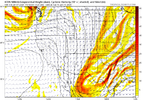
It’s related to the northern stream energyView attachment 160682
So our cold feed high goes from Augusta to the Atlantic and we have a GL low in tandem? I don't remember seeing that before, especially where we still end up with a winter storm.


 Definitely colder
 Wow the Euro continues to improve!


Can we get a Euro loop please
Sent from my iPhone using Tapatalk

How’s temps look compare to earlier runs??


I'd like to see energy round base of the trough and see it go more neutral/negative, to @ILMRoss point with this positive tilt/flatter solution we compromise qpf. But this was an improvement for sure...... haha I haven't had measurable snow in 3 yrs and now I'm getting greedyThank you! That definitely looks better than the 12z run
Sent from my iPhone using Tapatalk
Colder out front, now if we can get the qpf to continue to trend upward we may just be on to something "big"This is a awesome last minute trend View attachment 160695