NBAcentel
Member
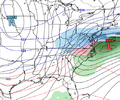
Euro is a VA hit 
Closer to what I’m thinking I’ll have a map later this week. Really not expecting ice. Snow mix or cold rain.Euro is a VA hit View attachment 158123


Knew that was coming. Could tell looking at UKMET. We get to wait and see who folds em and who holds em. I know who not to bet against, thats for sure!EURO says no to anybody along and south of 40 at 141
Very good consensus between Euro/EPS/Canadian and GEFS.Notice the track. Almost ticks SE at as it nears the coast.
View attachment 158127
Yeah ukie/euro combo is not to be messed with. Gonna build the snowpack at least.Knew that was coming. Could tell looking at UKMET. We get to wait and see who folds em and who holds em. I know who not to bet against, thats for sure!
This has been my basic reasoning for watching this period all along. -NAO and 50/50 are established, so it would favor a southern slider / further south event. I'm honestly not worried at this point - if every model was showing a hit over us at this range that would also be concerning haha. I think we're in the game for sure.If the Greenland block is really going to be as strong as advertised, and that huge 50/50, is in place, then the storm will correct south. We usually don't have these features in place, so we see cutter after cutter.
We're in for a winter storm with this one IF the features mentioned above turn out to be real and as strong and as well-positioned as advertised.
We have had rare occasions where systems trended south for those very reasons. If Euro doesn't shift any further south in next 24 hrs, this one is on life support, but it's too early to say that fow now.If the Greenland block is really going to be as strong as advertised, and that huge 50/50, is in place, then the storm will correct south. We usually don't have these features in place, so we see cutter after cutter.
We're in for a winter storm with this one IF the features mentioned above turn out to be real and as strong and as well-positioned as advertised.
It's rare, but it has happened. I've seen the Euro correct 900 miles towards the GFS with a winter event. These aren't huge differences and considering the pattern, it's 50/50 in my mind.Op runs compared...GFS on an island at the momemt. How many times has the GFS scored a win at day 5 against everyone else...
View attachment 158134

May not be the case this year, but both were bad last January with the snow event here in Tennessee. The UKIE was wound tight and areas that got a 10 inch snowfall were in the 50s with rain on it 84 hours out. The Euro was even worse, it went from a cutter to extreme suppression and didn't actually get close to what happened until around 60-72 hour out runs.Yeah ukie/euro combo is not to be messed with. Gonna build the snowpack at least.
TouchéMay not be the case this year, but both were bad last January with the snow event here in Tennessee. The UKIE was wound tight and areas that got a 10 inch snowfall were in the 50s with rain on it 84 hours out. The Euro was even worse, it went from a cutter to extreme suppression and didn't actually get close to what happened until around 60-72 hour out runs.
The gfs ens says it’s not out to lunchI personally think the CMC is the most realistic solution out of 12z suite, GFS is out to lunch, unless the NAO block and the 50/50 completely disappears there's no way the storm cuts like the UK has it. And the Euro historically doesn't catch on to CAD events this far out.
UKMET was also a hard nope. Probably to far north but Idk something doesn’t ring it for me with this one. The GFS on a southern island isn’t very encouraging to me at all. We need to start seeing trends asap on other major global NWP and ensembles to more confluence other then the GFS/GEFSView attachment 158124


Insitu WedgeYeah the thing I’m (still) worried about here is the high is in the wrong spot for a CAD event & we don’t really have a good mechanism to keep the cold firmly locked in place in the low-levels. Everything still looks great at 500mb.
This can definitely work but we are leaving the door wide open for the heaviest snow/ice to shoot northward at the last second.
I’d personally like to see the wave slow down so more cold air can get out in front of it, then I’d be a happy camper.
If and it’s a big if you keep the -NAO that all are showing, we could very easily just get a storm that moves west to east vs cutting straight northeast with more relaxed heights out ahead of it. But I also think this has a much higher probably of being an ice issue for pretty much everybody south of the Va border if it does anything other than rain. It’s very likely to go inland without a real CAD damming high like you said it’s just a matter of how far inland does it goYeah the thing I’m (still) worried about here is the high is in the wrong spot for a CAD event & we don’t really have a good mechanism to keep the cold firmly locked in place in the low-levels. Everything still looks great at 500mb.
This can definitely work but we are leaving the door wide open for the heaviest snow/ice to shoot northward at the last second.
I’d personally like to see the wave slow down so more cold air can get out in front of it, then I’d be a happy camper.
View attachment 158138
View attachment 158139
VA hit but it’s only 10 miles north of me would be roughhhhEuro is a VA hit View attachment 158123
I saw this earlier. I think this is the general consensus for the upstate as well. Have it here in Rock Hill tooGSP now has Rain and snow in my forecast for Sunday night and Monday. Low Sunday night 27 degrees with a 60% chance of precip. Going to be fun to track.
I too would like to see that wave slow down and allow the cold air to become more infused with this system. Unfortunately the model runs I've seen seem to be gradually speeding this wave up. Timing is a crucial element for this potential winter weather producer and the other possible winter storms that come our way in the Southeast.Yeah the thing I’m (still) worried about here is the high is in the wrong spot for a CAD event & we don’t really have a good mechanism to keep the cold firmly locked in place in the low-levels. Everything still looks great at 500mb.
This can definitely work but we are leaving the door wide open for the heaviest snow/ice to shoot northward at the last second.
I’d personally like to see the wave slow down so more cold air can get out in front of it, then I’d be a happy camper.
View attachment 158138
View attachment 158139
It did slow the storm a bit. The next frame it jumps to the coast and does change the interior parts of NC over to freezing rain.