 12k NAM /latest run! Hug the NAM! Yes i know, there's not snow! Boom! Coutesy AmWX!
-
Hello, please take a minute to check out our awesome content, contributed by the wonderful members of our community. We hope you'll add your own thoughts and opinions by making a free account!
You are using an out of date browser. It may not display this or other websites correctly.
You should upgrade or use an alternative browser.
You should upgrade or use an alternative browser.
Wintry 2/3-2/4 Mixed Bag NC, SC, NE GA
- Thread starter Blue_Ridge_Escarpment
- Start date
ForsythSnow
Moderator
You know that's the 12KM NAM and we are in a very short range, so use the 3 KM. It's better. Here is where the run expects sleet and ZR. Mind I said sleet too. Second image shows why.View attachment 3758 12k NAM /latest run! Hug the NAM! Yes i know, there's not snow! Boom! Coutesy AmWX!
.png")

gawxnative
Member
You know that's the 12KM NAM and we are in a very short range, so use the 3 KM. It's better. Here is where the run expects sleet and ZR. Mind I said sleet too. Second image shows why.
View attachment 3759 View attachment 3759 View attachment 3759
gawxnative
Member
Well at least you made it into the SWS that FFC just issued...You know that's the 12KM NAM and we are in a very short range, so use the 3 KM. It's better. Here is where the run expects sleet and ZR. Mind I said sleet too. Second image shows why.
View attachment 3759 View attachment 3759 View attachment 3759
That looks even better for MBY!! There's a lot of high lollipops in NEGA!You know that's the 12KM NAM and we are in a very short range, so use the 3 KM. It's better. Here is where the run expects sleet and ZR. Mind I said sleet too. Second image shows why.
View attachment 3759 View attachment 3759 View attachment 3759
The NAM shows wintry precip near Chattanooga yet there's not even a SWS out for that area.
ForsythSnow
Moderator
Yep, and they now have Forsyth getting a lot more time than expected. Have to see the specifics tonight to see if the models are going to underplay the CAD or get it right.Well at least you made it into the SWS that FFC just issued...
packfan98
Moderator
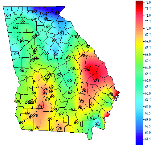
Here's the best candidates for ice accrual. Take a look at where this map has below freezing temps.

Looks like Georgia is out of the game.Here's the best candidates for ice accrual. Take a look at where this map has below freezing temps.
Kylo
Member
RGEM is getting more icy each run
 .
.
.Yeah, latest run only gives me .85 of accumulated ice!!! Glad it's on an island!
Kylo
Member
Yeah, latest run only gives me .85 of accumulated ice!!! Glad it's on an island!
I don't know. The GFS should be concerning, it's usually a little warm in situations like this. And it's been getting more icy too.

No one wants that! I need my trees! Verbatim it's prob not right. But it just confirms the colder stouter wedge trend shown on the NAMYeah, latest run only gives me .85 of accumulated ice!!! Glad it's on an island!
Figured I'd post this as a reminder.
Read the GSP discussion, mentioned it could get windy at some point tomorrow! RGEM has my back yard in the 2-3 category
ForsythSnow
Moderator
HRRR may be looking colder each run, and also seems to keep temps 33-36 and rain here. Seems very close, and if we keep the winds out of the NE like it shows, there are going to be issues, especially if the low goes south and pulls even more cold air down.
With temps forecast to be above freezing pretty much everywhere by noon tomorrow I would think this will be a low impact event ?
ForsythSnow
Moderator
Not according to the other runs. You can't go by that one map posted ealier, but all of the SR models and their trends. If they go the Here's what and trend colder, low impact is going to turn into ice storm. It all comes down to wind direction, low temps, temps when they wetbulb, low track, and start time.With temps forecast to be above freezing pretty much everywhere by noon tomorrow I would think this will be a low impact event ?
Aren't you forecast to be 45+ tomorrow afternoon ?Not according to the other runs. You can't go by that one map posted ealier, but all of the SR models and their trends. If they go the Here's what and trend colder, low impact is going to turn into ice storm. It all comes down to wind direction, low temps, temps when they wetbulb, low track, and start time.
ForsythSnow
Moderator
I looked at the models and it's at the end of the day, like evening when the rain stops.Aren't you forecast to be 45+ tomorrow afternoon ?
ForsythSnow
Moderator
It's also going to be interesting watching how the area responds in general to this event, since it could be rain south of Sawnee mountain, but ZR north. Wonder of the models are just too low-res to pick it up.I looked at the models and it's at the end of the day, like evening when the rain stops.
BPATL
Member
Aren't you forecast to be 45+ tomorrow afternoon ?
Ya know I like you on here, but did you not use to live here, and then you went to live with Mother? Anyway, if you did, you know that CAD is always messed up, no model has ever figured it out. It is a bizarre micro climate. DP in Atlanta right now is 12 degrees...
I've lived in GA my entire life so i'm well aware of how CAD works. FFC seems to always underestimate the strength of the wedge for whatever reason.Ya know I like you on here, but did you not use to live here, and then you went to live with Mother? Anyway, if you did, you know that CAD is always messed up, no model has ever figured it out. It is a bizarre micro climate. DP in Atlanta right now is 12 degrees...
Webberweather53
Meteorologist
HRRR has busted horribly on overnight lows here lately in NC, it was off by several degrees just last night and only pushed RDU into the mid 20s, we reached 17...HRRR may be looking colder each run, and also seems to keep temps 33-36 and rain here. Seems very close, and if we keep the winds out of the NE like it shows, there are going to be issues, especially if the low goes south and pulls even more cold air down.
GeorgiaGirl
Member
Mesoscale models are better than the globals at forecasting CAD...don't get me wrong, I think the RGEM isn't going to be right but in this situation, use the NAM temps.
Think the CAD areas see a glaze to up to 0.25 before changing to rain. Possible to get close to problems but I'm not sure.
Think the CAD areas see a glaze to up to 0.25 before changing to rain. Possible to get close to problems but I'm not sure.
Webberweather53
Meteorologist
Heres HRRR verification for last night here in central NC. Not even close, way too warm just about everywhere. This has been a fairly regular occurrence of late from what I've noticed


The HRRR just upped its game! Gives me .40 of ice accumulate. Trending..... Now I'm in the bullseye on 3-4 models!! Skies are very clear right now, temps falling quickMesoscale models are better than the globals at forecasting CAD...don't get me wrong, I think the RGEM isn't going to be right but in this situation, use the NAM temps.
Think the CAD areas see a glaze to up to 0.25 before changing to rain. Possible to get close to problems but I'm not sure.
I'm not expecting anything other than rain(and maybe a brief episode of sleet to start) in my portion of Cherokee since FFC is saying zr/sleet at onset possible. I'm at 43/14 as of this hour with a wet bulb around 33/34. Will be interesting to see what areas are able to get down to near 32 or below for sure though.
ForsythSnow
Moderator
By that logic, we're going to be in for ice all over here tomorrow.HRRR has busted horribly on overnight lows here lately in NC, it was off by several degrees just last night and only pushed RDU into the mid 20s, we reached 17...
This is starting to have that eerie feeling here in upstate SC...i love winter weather as much as the next guy but ice sucks!
NOT! Let's bring the noise!
NOT! Let's bring the noise!
GeorgiaGirl
Member
.

Kylo
Member
The HRRR just upped its game! Gives me .40 of ice accumulate. Trending..... Now I'm in the bullseye on 3-4 models!! Skies are very clear right now, temps falling quick
I wonder how close this could get to a December 2005 for your area up into western NC.
That might be tough! I hear that one mentioned a lot, right behind Dec '02 ( holy grail of ice storms in my life) ! There is a lot of moisture, moderate to heavy precip will be around, lock in the in situ , get temps to 30, look out!I wonder how close this could get to a December 2005 for your area up into western NC.
BPATL
Member
It is a bit concerning the temperatures around this area even currently. Hopefully the flow will begin to raise our temperatures as we approach the onset of precipitation.......
Thankfully this area has not had any ridiculous model runs, but I don't like seeing mid 30s next to my back yard already, with wedges underdone by modeling.
Thankfully this area has not had any ridiculous model runs, but I don't like seeing mid 30s next to my back yard already, with wedges underdone by modeling.
i was thinking same thing ShawnIt is a bit concerning the temperatures around this area even currently. Hopefully the flow will begin to raise our temperatures as we approach the onset of precipitation.......
Thankfully this area has not had any ridiculous model runs, but I don't like seeing mid 30s next to my back yard already, with wedges underdone by modeling.
i was thinking same thing Shawn
I went over the NAM/GFS MOS data and there really is no support for anything but rain, I would expect at least the cold bias of the RGEM to be showing something here by now. 35F and rain is always fun, lol. I can't see all ensemble members, the cold canadian, and icon all busting on the temperature here, but still.
Cold north wind in Cleveland TN
yea and 33 and rain is the worst lol! I think we will be ok.I went over the NAM/GFS MOS data and there really is no support for anything but rain, I would expect at least the cold bias of the RGEM to be showing something here by now. 35F and rain is always fun, lol. I can't see all ensemble members, the cold canadian, and icon all busting on the temperature here, but still.
GeorgiaGirl
Member
I remember an ice storm from the past in which either the mets just completely ignored guidance or the models all busted with this area, but that was 14 years ago.
I don't expect to see anything, and I'm fine with it, but just something to think about. It was likely close to borderline then, with this it's not. CAD temps are better forecasted by mesoscales (not the precip itself) but at times it seems to have a mind of it's own. I've seen a number of times in which my temp is a number of degrees below what was actually expected due to CAD. It doesn't mean a whole lot outside of nitpicking, but with an actual winter situation, that isn't fun to deal with for people that can be involved in this, like upstate SC and northward.
I fully expect my high to bust lower than what I have forecasted tomorrow, as usual with CAD.