• Hello, please take a minute to check out our awesome content, contributed by the wonderful members of our community. We hope you'll add your own thoughts and opinions by making a free account!

Wintry Winter 26-27

Still so weird to see average snowfall last winter and yet it was the warmest ever outside of one week haha

We've had colder winters barely even snow

And technically for two years running we've had solid winters on snow

So yeah who knows. The last El Nino sucked though. 1.6"! That's the scary part

Oh and for everyone who talks about February 2021. We went from -13 to 74 in a week. It's like all the winter came at once. The rest of the winter was really nothing here

That seems to happen a lot here. January was less extreme but very similar idea
 
Tony @dsaur and I would take that in a heartbeat! And then came the amazing historic >2” of sleet that I got here in Jan of 2025. My total incl. snow was 2.9”. I never thought I’d see that much down here! It took 4-5 days to melt in the shade and kept shaded roads in bad shape for several days.
Woah, thundersleet. Thundersleet in at 32 to 1, lol. I've seen a great thunder snow, with lightening lighting up the falling heavy snow, but I bet lightening off of heavy sleet would be magical too!
 
Woah, thundersleet. Thundersleet in at 32 to 1, lol. I've seen a great thunder snow, with lightening lighting up the falling heavy snow, but I bet lightening off of heavy sleet would be magical too!

I saw thunder snow in Charleston SC in 2010 with our snowstorm


Sent from my iPhone using Tapatalk
 
My most memorable experience by far with thunder snow was during the blizzard of 3/13/1993 N of ATL.
Did you do this?

thundersnow.gif
 
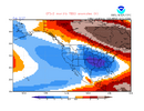
Latest CFSv2 10 day mean 850 mb fcast anomalies for Feb of 2027: note that >75% of Conus BN, including ~1/3 of Conus 2-4 C BN, along with the extreme warmth in E Canada that is consistent with strong blocking there allowing the diverting of dominant Arctic cold into much of Conus:
IMG_3059.png

——————
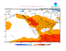
In stark contrast, mid-Oct forecast for Feb ‘24: 85% AN in Conus/no block in E Canada in that much weaker/much less E based Nino vs 26-7:
IMG_3061.png

—————
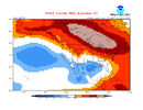
In sharp contrast to mid-Oct forecast for Feb ‘16: only <15% BN, none sub -2C, and less extreme Canadian warmth centered >1,000 miles W of the Feb ‘27 forecast in that much less E based Nino vs 26-7:
IMG_3062.gif
 
Latest CFSv2 10 day mean 850 mb fcast anomalies for Feb of 2027: note that >75% of Conus BN, including ~1/3 of Conus 2-4 C BN, along with the extreme warmth in E Canada that is consistent with strong blocking there allowing the diverting of dominant Arctic cold into much of Conus:
View attachment 199064

——————
In stark contrast, mid-Oct forecast for Feb ‘24: 85% AN in Conus/no block in E Canada in that much weaker/much less E based Nino vs 26-7:
View attachment 199065

—————
In sharp contrast to mid-Oct forecast for Feb ‘16: only <15% BN, none sub -2C, and less extreme Canadian warmth centered >1,000 miles W of the Feb ‘27 forecast in that much less E based Nino vs 26-7:
View attachment 199066
2023-2024 is in my analog package but I would really really really like to not see us repeat that atrocity again. This certainly looks optimistic.
 
2023-2024 is in my analog package but I would really really really like to not see us repeat that atrocity again. This certainly looks optimistic.

23-24 was a much weaker Nino and much less E based. I’m educatedly guessing that the very E based 26-7 more than likely helps shift the Canadian blocking much further E into a W -NAO position that includes E Canada in Feb. Also, Nino climo favors Feb to be the coldest of DJF in the E US.
 

Thanks for sharing this. Biggest clue to watch in Nov is the pv and see if it doesnt tip its hand how its gonna behave DJF. If we get it to cooperate early on in a way favorable to promote season long neg AO/ NAO/ we will be having historically good times on here this winter.

jury is out and im a biased juror in the jury pool. Been scortched by past couple el ninos. So anyone or anything trying to persuade me into buying any hype this winter best have some receipts.
 
Literally 4 hours later! Complete 180!
BOB is starting to lose street cred with me!
And I grew up on the mean streets of Gastonia!😂View attachment 199060
Does this guy just pump out random slop maps daily, or something? I’ve never seen so many maps from one guy, and they rarely have much congruity. There’s also no need for daily seasonal forecast updates, LOL.
 
Does this guy just pump out random slop maps daily, or something? I’ve never seen so many maps from one guy, and they rarely have much congruity. There’s also no need for daily seasonal forecast updates, LOL.
Yes. He’s bonkers. The absolute gold standard for unrealistic hype and lack of substance. That may sound harsh, but I think I’m being kind.
 
Just some of my thoughts as of today, 82-83 and 15-16 are probably the better analogs passing 97-98 with 23-24 as a secondary. December runs the highest risk of AN, Feb the highest risk of BN, January falls into the it depends on how quickly the pattern progresses this winter but likely nets out close to normal. If you consider March part of winter, I lean cold but I am not super confident anymore.

Precip is AN but don't ignore the potential for some drier periods especially in January. Snowfall is near impossible, pattern should at times get hyperactive, good luck planning out if we are just cold enough or 33 and rain. Snowfall forecasts imo are either saying AN precip must mean AN snow or BN snow because nino warm lolz. Pattern will be too susceptible to any north pac action loading cold or SER flexing to really dial in snow. If you wanted a forecast for me using RDU as a measuring stick I would say 2-15. We probably have a stretch of almost events that make this winter fun or incredibly frustrating depending on your local outcome.

I would take 2” or 15” and I would be happy I just love seeing snow or sleet on the ground. And preferably enough to keep work closed


Sent from my iPhone using Tapatalk
 
Just some of my thoughts as of today, 82-83 and 15-16 are probably the better analogs passing 97-98 with 23-24 as a secondary. December runs the highest risk of AN, Feb the highest risk of BN, January falls into the it depends on how quickly the pattern progresses this winter but likely nets out close to normal. If you consider March part of winter, I lean cold but I am not super confident anymore.

Precip is AN but don't ignore the potential for some drier periods especially in January. Snowfall is near impossible, pattern should at times get hyperactive, good luck planning out if we are just cold enough or 33 and rain. Snowfall forecasts imo are either saying AN precip must mean AN snow or BN snow because nino warm lolz. Pattern will be too susceptible to any north pac action loading cold or SER flexing to really dial in snow. If you wanted a forecast for me using RDU as a measuring stick I would say 2-15. We probably have a stretch of almost events that make this winter fun or incredibly frustrating depending on your local outcome.
Just going by the event maps and nothing else locally, 82-83 intriguing (crazy late March event I assume a coastal bomb). 15-16 close but no cigar.

At least we would have stuff to track if those are the closest analogs at this point.
 
Just going by the event maps and nothing else locally, 82-83 intriguing (crazy late March event I assume a coastal bomb). 15-16 close but no cigar.

At least we would have stuff to track if those are the closest analogs at this point.

Yeah that 82-83 event is one of those you can't depend on but have to keep it in the back of your mind if the pattern can evolve properly.

One thing that intrigues me about this winter and ninos in general is when we can get 2 independent streams and the northern one is ahead of the southern. It's a great way for us to get the lower end less than 1 inch to 3 inch type events
 
Just some of my thoughts as of today, 82-83 and 15-16 are probably the better analogs passing 97-98 with 23-24 as a secondary. December runs the highest risk of AN, Feb the highest risk of BN, January falls into the it depends on how quickly the pattern progresses this winter but likely nets out close to normal. If you consider March part of winter, I lean cold but I am not super confident anymore.

Precip is AN but don't ignore the potential for some drier periods especially in January. Snowfall is near impossible, pattern should at times get hyperactive, good luck planning out if we are just cold enough or 33 and rain. Snowfall forecasts imo are either saying AN precip must mean AN snow or BN snow because nino warm lolz. Pattern will be too susceptible to any north pac action loading cold or SER flexing to really dial in snow. If you wanted a forecast for me using RDU as a measuring stick I would say 2-15. We probably have a stretch of almost events that make this winter fun or incredibly frustrating depending on your local outcome.

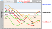
From the combo of QBO/strength of Nino 3.4 standpoint, I have 2015-6 as the closest, 1982-3 as 2nd, 1957-8 as 3rd, and 1997-8 is 4th. But when I look at how far E based 2026-7 is/is expected to be in winter, I see that 2015-6 isn’t close, 1997-8 is close, and 1982-3 is close. Also, 1877-8 was very strong in 3.4 and was strongly E based per griteater’s graph and thus should be considered, but there’s no QBO that far back. 1957-8 was Nino 3.4 based and thus isn’t close for its base.

So, in summary, 1982-3 is the best analog of these imho. 1997-8 is probably 2nd.

Griteater’s graph of El Niño base:
IMG_2948.png

*Corrected for error: 1877-8, not 1888-9
 
Last edited:
From the combo of QBO/strength of Nino 3.4 standpoint, I have 2015-6 as the closest, 1982-3 as 2nd, 1957-8 as 3rd, and 1997-8 is 4th. But when I look at how far E based 2026-7 is/is expected to be in winter, I see that 2015-6 isn’t close, 1997-8 is close, and 1982-3 is close. Also, 1877-8 was very strong in 3.4 and was strongly E based per griteater’s graph and thus should be considered, but there’s no QBO that far back. 1957-8 was Nino 3.4 based and thus isn’t close for its base.

So, in summary, 1982-3 is the best analog of these imho. 1997-8 is probably 2nd.

Griteater’s graph of El Niño base:
View attachment 199068

*Corrected for error: 1877-8, not 1888-9
I got burned big time in the summer when I was thinking about fall and immediately said 97 was a slam dunk. So far we have seen some semblance of 97 but not enough for me to champion it like I was. The overall pattern construct and evolution so far looks enough like 15 so that I put it ahead of 97 but if we were applying percentages to it it's like 82 30%, 15 25%, 97 20% so not a huge difference. November to me is going to be when we start to really separate these analog years and the picture for a good part of winter becomes more clear. How the AK to Baja corridor in concert with the PJ react will be telling and probably more so than other years.
 
People talking about a behind schedule freeze here already(last year for all the torching it did happen normally)

And for all the rain that occurred in OKC and points west a couple weeks ago we are still in a drought and people in Arkansas are wondering if it will ever rain again because all that rain didn't make it over there

It's gonna be a long annoying winter I'm afraid. I have a sense of dread when I go on social media at this point
 
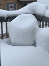
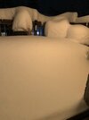
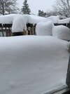
I keep seeing the ‘23/24’ winter analog showing up! That was a sucky winter up here! Basically 2’ of snow from two double digit snows in a week, in January, and nothing after that! But did make for good chair pics! IMG_0973.jpegIMG_4368.jpegIMG_0744.jpegIMG_0736.jpeg
 
I keep seeing the ‘23/24’ winter analog showing up! That was a sucky winter up here! Basically 2’ of snow from two double digit snows in a week, in January, and nothing after that! But did make for good chair pics! View attachment 199076View attachment 199075View attachment 199077View attachment 199078

It was trash here and of course we had the infamous snow hole. I also don't think people realize how lucky we were last year to get 8-10 inches in the middle of the most historic torch on record here... People keep saying it can't be any worse. Oh it can be worse trust me. There's been plenty of years we basically only had a dusting. I don't even want to read some of these comments if it happens again because yeah last winter was a nightmare outside of one week which was pretty much a total miracle it even happened. So many people think we're owed something because of how bad the summer was. Oh have I got news for them...

I mean I hope everyone is wrong but yikes
 
The winter of 2015-2016 was awful. This is the only event I remember and it was all-sleet while DC-NYC got a thousand inches of snow for the third time in like six years. 💀

january_22-23_2016_nc_snowmap.gif


January_2016_United_States_blizzard_RSI_map.png

Unfortunately, there are a lot of events like that in big Nino winters with sharp snowfall gradients across the Piedmont because of the amplified storm track.
 
Latest CFSv2 10 day mean 850 mb fcast anomalies for Feb of 2027: note that >75% of Conus BN, including ~1/3 of Conus 2-4 C BN, along with the extreme warmth in E Canada that is consistent with strong blocking there allowing the diverting of dominant Arctic cold into much of Conus:
View attachment 199064

——————
In stark contrast, mid-Oct forecast for Feb ‘24: 85% AN in Conus/no block in E Canada in that much weaker/much less E based Nino vs 26-7:
View attachment 199065

—————
In sharp contrast to mid-Oct forecast for Feb ‘16: only <15% BN, none sub -2C, and less extreme Canadian warmth centered >1,000 miles W of the Feb ‘27 forecast in that much less E based Nino vs 26-7:
View attachment 199066

Although I do think the CFS is optimistic, the sheer strength and eastward shift of this El Niño even compared to 1997-98, does lend some credence to its forecast of stronger/eastward shifted cool anomalies in late winter. This forecast also inevitably implies a very amplified storm track which can be to the benefit of the Appalachians, foothills, and perhaps parts of the OH/TN valley.
 
R people really shocked, with this kind of el
Nino that’s taking place lol
Does El Nino or in this case off the charts el nino have any effect on the PV? How so, through domino effect on other things/factors? Curious. Past couple el nino's as I recall, the PV stayed wrapped up like a iron fist majority of the time
 
Does El Nino or in this case off the charts el nino have any effect on the PV? How so, through domino effect on other things/factors? Curious. Past couple el nino's as I recall, the PV stayed wrapped up like a iron fist majority of the time
My understanding is yes. Enhanced tropical convection from the nino alters the pacific wave train, there is more momentum and heat transported upward into the strat, the pv gradually becomes more susceptible to warming/stretching/splitting. It's more of a mid to later winter deal though in a nino and what we are seeing now is unusual. Big things to watch this winter to see if we can do it again will be persistent ridging at 500mb in the urals/aleutians/AK or even the NAO region they are usually precursors. One thing to remember also is the current QBO state favors a stronger PV so we may end up with some tug of war through the season
 
Does El Nino or in this case off the charts el nino have any effect on the PV? How so, through domino effect on other things/factors? Curious. Past couple el nino's as I recall, the PV stayed wrapped up like a iron fist majority of the time

My understanding is yes. Enhanced tropical convection from the nino alters the pacific wave train, there is more momentum and heat transported upward into the strat, the pv gradually becomes more susceptible to warming/stretching/splitting. It's more of a mid to later winter deal though in a nino and what we are seeing now is unusual. Big things to watch this winter to see if we can do it again will be persistent ridging at 500mb in the urals/aleutians/AK or even the NAO region they are usually precursors. One thing to remember also is the current QBO state favors a stronger PV so we may end up with some tug of war through the season

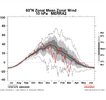
I was curious and thus just looked at all Ninos back to 1957-8 that peaked at +1.4+ RONI to see how the SPV was (data goes back to 1958) keeping in mind 26-7 will very likely be solidly +QBO at 30 mb:

2023-4 had weak SPV DJF, including an SSW mid-Jan, but was -QBO:
IMG_3090.jpeg

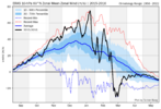
2015-6 had strong SPV DJF and was +QBO:
IMG_3184.png

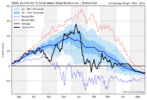
2009-10 had slightly strong SPV 1st half of winter, but weak SPV 2nd half, including 2 SSWs in Feb but it clearly had -QBO:
IMG_3158.png

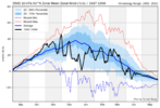
1997-8 had weak SPV DJF, including a near SSW in early Jan, but was neutral QBO
IMG_3088.png

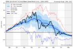
1991-2 had strong SPV Dec-early Jan and weak SPV mid Jan-Feb (avg DJF SPV neutral), but was -QBO:
IMG_3089.png

1986-7 had slightly strong SPV Dec and weak SPV JF, including a very long SSW late Jan-Feb, but was -QBO:
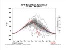
IMG_3094.jpeg

1982-3 had strong SPV DJ and neutral SPV F and was +QBO:
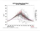
IMG_3091.jpeg

1972-3 had an SSW Feb 2nd but was -QBO DJ and neutral QBO F:
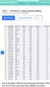
IMG_3092.jpeg

1965-6 had an SSW on Dec 8th and another on Feb 24th but was -QBO:
see SSW table I posted for 1972-3

1957-8 had an SSW Jan 30th, a very cold Feb, and was +QBO:
see SSW table I posted for 1972-3
—————————

To summarize:
- the weak overall DJF SPVs of 2023-4, 2009-10, and 1986-7 as well as 1972-3 and 1965-6 that each had 1-2 SSWs were during -QBO.

-the weak DJF SPV of 1997-8 had a neutral QBO

-the neutral DJF SPV of 1991-2 had a -QBO

-the strong overall DJF SPVs of 2015-6 and 1982-3 were during +QBO

-The only exception among these 10 that had a weak overall SSW DJF and/or one or more SSWs and also had a +QBO was 1957-8
———————

Observations:
1. QBO stats for strong El Niño clearly favor a stronger than normal overall DJF SPV for 26-7 due to a +QBO

2. But 1957-8 was +QBO and had an SSW Jan 30th along with a very cold Feb. So, there was that exception. Plus, the CFS has been very persistent on predicting a strong W based -NAO for Feb along with a mainly cold CONUS as a result of that.

3. Seasonal models that I’ve seen **fwiw** favoring a weak SPV later this winter although a strong SPV in Dec.
—————————

Conclusion:
Based on all of the above, I expect a stronger than normal SPV as well as mild E US in Dec. After that the jury’s out especially for late Jan through Feb due to CFSv2 progs for Feb showing a -NAO/mainly cold CONUS as well as the +QBO 1957-8 having both an SSW Jan 30th and a very cold/strong -NAO Feb.

 
Last edited:
Back
Top