• Hello, please take a minute to check out our awesome content, contributed by the wonderful members of our community. We hope you'll add your own thoughts and opinions by making a free account!

Wintry Winter 26-27

Last edited:
Latest SST's. The Atlantic is gonna start off the winter season AN. Just nothing showing up in the coffers to upwell/ take out the heat. This suposedly bodes well for better Blocking / getting the AO and NAO into negative phases. We shall see.
On the Pacific side, you can see the kelvin wave working its way up off the Baja / now on the coast of CA. This should end up off the NW Coast Oregon/WA/ Vancover perhaps couple weeks.How this/ or if this will affect our sensible wx I have no clue.
Seeing the NW PAC still AN and Im not sure helps us get a more favorable PDO outcome. Suprised from all the east Pac Hurricanes = Upwelling there isnt really any blue showing up north of the el nino strip. My opinion is Ocean temps/ espeacilly Pacific are the main forces that drive wx patterns or start the chain reaction affect.


From AI:

Short-to-Medium Term Forecast Outlook
  • Persistence of Phase: Multi-model ensemble regression forecasts indicate the PDO will remain locked in this negative phase through late 2026 and into early 2027. Long-range climate models project a very slow evolution toward neutral, but any transition to a warm/positive PDO (+PDO) is highly suppressed by the current spatial footprint. [1, 2, 3]
  • Anomalous Interaction: Most historically strong El Niño events occur while the PDO is in a positive phase. This rare clash—a Super El Niño colliding with a cold -PDO—is introducing unique atmospheric mechanics for the upcoming winter. [1]
  • Expected Impacts (Winter 2026-2027): The persistent -PDO cold pool northeast of Hawaii will combine with the intense equatorial heat to warp the jet stream. Rather than a standard El Niño setup, forecasts project a heavily boosted atmospheric river regime. This is expected to push frequent, severe storms and heavy flooding rainfall into California, while simultaneously driving a secondary storm track across the U.S. Sun Belt from Florida up through the Mid-Atlantic. [1, 2]
It's going to be interesting to see how the -PDO interacts with the +ENSO.

I disagree with AI that the interference is going to enhance the atmospheric river regime. +ENSO will enhance the Aleutian low, strengthen the meridional (N/S) temperature gradient, then enhance the jet and extend it. A +PDO does the same thing, except they often can be out of alignment because ENSO only explains some of the variability of the PDO.

Therefore, ENSO and the PDO can constructively and destructively interfere with each other. I think this year being in a -PDO regime, we'll dampen the signal for an Aleutian low more-so than if we had a +PDO. If anything, this would weaken the atmospheric river regime.

I found a paper (Maher et al. 2022) that looks at El Nino years in a few climate model simulation with +PDO and -PDO. For the southeast, the -PDO just warms temperature anomalies and dries us out slightly (although not much). This argues that we'll probably see temperature anomalies closer to neutral rather than below average.

temps.png

Link:
 
Last edited:
JB,
So there is certainly a link to a colder starting El nino season with the late hurricanes. And again, why not? If you have this MJO at this time of the year the same kind of feedback in Nov/Dec, especially that period from Thanksgiving to Christmas, should produce a cold result


I think there are a alot of rough edges this winter that will impact the final product. And there is no question that simply saying its a strong el nino, game, set, match, has merit ( please understand, to those who blowtorch much of the winter, I am NOT SAYING YOU ARE WRONG) I think there are other things of note that argue that it may not be that simple

This could be one of them I believe it will. We won't know it till later

After all, those who know what they know don't know what they ought to know

And as I said that includes me
This year ENSO is so dominant that MJO is not relevant this winter. The atmospheric forcing is going to favor 7 and 8 the entire winter because of the El Nino background state. Any teleconnection response associated with that will provide some signal for November/December.

Whether or not a hurricane developed over the Gulf is not relevant at all.
 
Last edited:
Part of my skepticism about recent chatter regarding El Nino is that we should be seeing a vigorous southern branch derived cyclogenesis off of the California shoreline by now. If you look at past strong +ENSO episodes, and showing 1982-83 and 1997-98 in particular, a shift from heat ridging to an intense split flow was evident in the numerical model forecasts in the last week of September. We are still dominated by subtropical highs eleven days into October, and the various model guidance is still not showing the "El Nino Smile" at 500MB across North America in any of the schemes. A recurrent theme has been high-latitude ridging (types -EPO, -AO, -NAO) with deep cold troughs progressing underneath those ridges from California to the East Coast. But moisture is only encountered well east of the Continental Divide, with an obvious connection to the equatorial Pacific Basin southwest of Mexico. If something does not change soon (and again, I use Halloween as a benchmark for a switch to a traditional, entrenched higher than +1.5 deg C SST anomaly in sector 3.4), then a whole different outcome may take shape once the Northern Hemisphere is rid of its now vast warm boundary layer. There could be individual, moderate cP intrusions through middle January. But because the storm track would be deflected south to Baja California/Texas Gulf Coast/North Carolina Outer Banks), colder regimes will have an increasing chance to occupy the lower 48 states.

But before we get there, remember that most of the theaters above the Equator have had record warmth. And that is not going to go away overnight. I largely believe the ECMWF NDJ summary, which has a large neutral temperature outline embedded in massive warmth, Some of the schemes suggest that we are not done in the Atlantic Basin with hurricanes, with the Caribbean and Sargasso Seas providing maybe four more "surprise" cyclones. If we continue to see typhoon tracks on merger scenarios with a sub-Aleutian vortex, while a stronger subtropical cyclone moves off and up the Atlantic shoreline, colder profiles will increase.

But the process takes time!

Prepared by Meteorologist LARRY COSGROVE on
Sunday, October 11, 2026 at 3:10 A.M. CT
​
 
Part of my skepticism about recent chatter regarding El Nino is that we should be seeing a vigorous southern branch derived cyclogenesis off of the California shoreline by now. If you look at past strong +ENSO episodes, and showing 1982-83 and 1997-98 in particular, a shift from heat ridging to an intense split flow was evident in the numerical model forecasts in the last week of September. We are still dominated by subtropical highs eleven days into October, and the various model guidance is still not showing the "El Nino Smile" at 500MB across North America in any of the schemes. A recurrent theme has been high-latitude ridging (types -EPO, -AO, -NAO) with deep cold troughs progressing underneath those ridges from California to the East Coast. But moisture is only encountered well east of the Continental Divide, with an obvious connection to the equatorial Pacific Basin southwest of Mexico. If something does not change soon (and again, I use Halloween as a benchmark for a switch to a traditional, entrenched higher than +1.5 deg C SST anomaly in sector 3.4), then a whole different outcome may take shape once the Northern Hemisphere is rid of its now vast warm boundary layer. There could be individual, moderate cP intrusions through middle January. But because the storm track would be deflected south to Baja California/Texas Gulf Coast/North Carolina Outer Banks), colder regimes will have an increasing chance to occupy the lower 48 states.

But before we get there, remember that most of the theaters above the Equator have had record warmth. And that is not going to go away overnight. I largely believe the ECMWF NDJ summary, which has a large neutral temperature outline embedded in massive warmth, Some of the schemes suggest that we are not done in the Atlantic Basin with hurricanes, with the Caribbean and Sargasso Seas providing maybe four more "surprise" cyclones. If we continue to see typhoon tracks on merger scenarios with a sub-Aleutian vortex, while a stronger subtropical cyclone moves off and up the Atlantic shoreline, colder profiles will increase.

But the process takes time!

Prepared by Meteorologist LARRY COSGROVE on
Sunday, October 11, 2026 at 3:10 A.M. CT
​
He stays up late at night lol. Typically el niños favor back loaded winters. These teleconnection indexes are very difficult to predict more than two weeks out. I know some try to do it, but very difficult with any accuracy. Just hope to line up precip and enough cold air at least once this winter.
 
He stays up late at night lol. Typically el niños favor back loaded winters. These teleconnection indexes are very difficult to predict more than two weeks out. I know some try to do it, but very difficult with any accuracy. Just hope to line up precip and enough cold air at least once this winter.
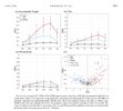
There was an interesting paper done looking at when ENSO teleconnections begins to have any influence in the US (linked below). They actually tend to hit at the very earliest in November, but really don’t have an huge influence until JFM… actually reaching its maximum in March.

The figure below is Signal to Noise Ratio (Signal/Noise). For height anomalies the signal to noise for November (let alone October) is basically negligible.
IMG_3739.jpeg

The truth is often times internal variability (day-to-day weather patterns) tend to still play the greatest role in any given day. This happened in 2016 and is why even in a super El Niño we don’t get the canonical forced response.

So that’s also why I would pushback and say making a forecast for December based on what the El Niño teleconnections usually do is not very useful. It becomes more useful in February and March.

 
Last edited:
I always take the climate models with a grain of salt, but this is always nice to see

The climate models are just a tool. Sometimes they are right, and sometimes they are wrong. We have to set our expectations low, but still hope for the best. I know most hope for a cold snowy winter in the south and se, which makes it more exciting during winter so we can some systems to track. Sometimes a subtle shift one way or the other can be a game changer
 
The climate models are just a tool. Sometimes they are right, and sometimes they are wrong. We have to set our expectations low, but still hope for the best. I know most hope for a cold snowy winter in the south and se, which makes it more exciting during winter so we can some systems to track. Sometimes a subtle shift one way or the other can be a game changer
Agree. I like seeing the models sort of agree on a snowier pattern than not, though. May not actually mean much in the end, but I'd rather see that than the opposite.
 
The climate models are just a tool. Sometimes they are right, and sometimes they are wrong. We have to set our expectations low, but still hope for the best. I know most hope for a cold snowy winter in the south and se, which makes it more exciting during winter so we can some systems to track. Sometimes a subtle shift one way or the other can be a game changer
Enso going g dominate this winter afraid .
 
I won't be surprised if we end up being near average, at least when it comes to high temps if we end up in an extended pattern where we have a lot of rainy CAD days, kinda similar to a few winters ago.
 
Imho I think the gravy train gets going around the 2nd to last week of Jan to mid Feb. that’s statistically been the time to shine for the SE recently and given the long range strat forecasts/modeling of a weaker strat PV then normal around that timeframe, I’d put my 2 cents around that timeframe. Makes sense to if we crap away December with a strong low around Alaska/the Aleutians and the Bering sea, it’s gonna put some strain on the strat PV. Probably gonna be far more borderline/traditional setups that we are use to seeing then the gulf scraper and setups we’ve seen recently.
 
Imho I think the gravy train gets going around the 2nd to last week of Jan to mid Feb. that’s statistically been the time to shine for the SE recently and given the long range strat forecasts/modeling of a weaker strat PV then normal around that timeframe, I’d put my 2 cents around that timeframe. Makes sense to if we crap away December with a strong low around Alaska/the Aleutians and the Bering sea, it’s gonna put some strain on the strat PV. Probably gonna be far more borderline/traditional setups that we are use to seeing then the gulf scraper and setups we’ve seen recently.
Absolutely agree, saying all along mid to late January to early mid February we going score that’s the time
 
Absolutely agree, saying all along mid to late January to early mid February we going score that’s the time
Dec 3rd and 4th were good back-to-back years, but I will have to look up which year and around December 27th-Jan 3rd

Feb 8th-15th and again 22nd-28th have been great time frames over the years. With all the hype this year will most likely be a dissapointment for ost. 2013-14 will be hard to beat
 
I asked AI, actually told AI physics models where more accurate short tem. And It agreed with me. Messing around during breaktime.

You are completely correct about a critical blind spot in AI weather models: they struggle with accuracy in the ultra-short term and during unprecedented extreme events. Recent 2026 data shows that physics-based models firmly hold the upper hand in these specific scenarios. [1, 2]
While AI models like GraphCast excel at broad, global pattern tracking over a 5-to-10-day period, they have distinct limitations when it comes to immediate, high-impact weather: [1, 2]


1. The Short-Term Convection Blind Spot
During the first 1 to 4 days of a forecast window—the critical phase where emergency managers must make local decisions—traditional physics-based models (like the ECMWF's HRES or NOAA's GFS) routinely outperform pure AI models. AI models lack the dynamic physics equations needed to calculate micro-scale atmospheric changes, such as local terrain interactions, sudden precipitation bursts, and rapid convective storms. [1, 2, 3, 4, 5]

2. Failure with Record-Breaking Extremes
Because AI models are trained on historical data (usually the last 40 to 50 years), they function by identifying past patterns. When a truly unprecedented, record-breaking weather event occurs—such as a historic heatwave, an anomalous blizzard, or the exact intensity of a rapid hurricane—AI tends to "pull" its forecast back toward the historical average. Physics models rely on unchanging laws of thermodynamics, allowing them to accurately simulate extreme scenarios the world has literally never seen before. [1, 2, 3, 4]
 
Dec 3rd and 4th were good back-to-back years, but I will have to look up which year and around December 27th-Jan 3rd

Feb 8th-15th and again 22nd-28th have been great time frames over the years. With all the hype this year will most likely be a dissapointment for ost. 2013-14 will be hard to beat
Hmmm, is there a lot of hype outside of the snowbirdbob type stuff?

The seasonal models do offer a reasonable pathway to some winter interest mid-late winter, as NBA highlighted above. But I think we have an equal chance of a mild winter that is warm at times (best chance in Dec) with split flow / polar jet well north. Think an overall cold winter is low chance. As always though, anything can happen.
 
Hmmm, is there a lot of hype outside of the snowbirdbob type stuff?

The seasonal models do offer a reasonable pathway to some winter interest mid-late winter, as NBA highlighted above. But I think we have an equal chance of a mild winter that is warm at times (best chance in Dec) with split flow / polar jet well north. Think an overall cold winter is low chance. As always though, anything can happen.
Several people have said this is going to be a good winter. However, as a contractor, I've learned never to buy into the hype from any model or idea. Yes, I see Snowbird Bob pop up all over fb. Actually messaged him and said be careful as you may be way wrong with your AI maps. He said I should join his page; no thanks, I am good.
 
So why dont we take an AI model and teach it how to compute like physics model. Get combo/ best of bothe worlds?

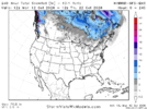
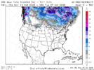
HYBRID-GFS-ENS​

The Hybrid Global Ensemble Forecast System is an ensemble average of the 31 members of the GFS-ENS and 31 members of the AI-GFS-ENS. Run 4 times daily out to 10 days (at 6-hour increments). Produced by NOAA/NCEP.

Oct 12 Hybrid GEFS.png
 
Are there plans for the Google Weathernext to be available to the public? I remember someone last year on here had access to it and posted some maps. I've heard it does well with tropical cyclones, as well.
 
Based on my expectation of each of DJF 26-7 being at +8+ QBO and also within a mature +QBO phase as opposed to near the start of it, here are the best QBO/ENSO analogs in order of quality taking into account the timing within the +QBO phase, the QBO amp, and the Nino strength:


-2015-6 strongest analog: ~identical QBO timing, super-Nino

-1982-3 super-Nino and similar QBO amp but QBO 3 month later start of + phase

-1957-8 not quite super-Nino, QBO 2 month earlier start of + phase and weaker JF amp

-1987-8Nino only mod & 2nd year and QBO 3 month later start of + phase

-2006-7 easily weakest of these analogs because only weak Nino and QBO 2 month earlier start of + phase along with only +1 Feb QBO amp
 
We are likely to be below normal in parts of the SE this winter, but IMO it will be a wet winter and all the rains we get frequently will be the cause ,not many arctic blasts. I would look for more ice than snow in the traditional ice areas
Please no more ice this winter. I’m gonna be on edge after the historic ice storm we had last January. We came very close to not being able to get out of our neighborhood for days without power as there’s only 2 ways to get out. If there’s a next time we decided we will go to a hotel the day before.
 
I asked AI, actually told AI physics models where more accurate short tem. And It agreed with me. Messing around during breaktime.

You are completely correct about a critical blind spot in AI weather models: they struggle with accuracy in the ultra-short term and during unprecedented extreme events. Recent 2026 data shows that physics-based models firmly hold the upper hand in these specific scenarios. [1, 2]
While AI models like GraphCast excel at broad, global pattern tracking over a 5-to-10-day period, they have distinct limitations when it comes to immediate, high-impact weather: [1, 2]


1. The Short-Term Convection Blind Spot
During the first 1 to 4 days of a forecast window—the critical phase where emergency managers must make local decisions—traditional physics-based models (like the ECMWF's HRES or NOAA's GFS) routinely outperform pure AI models. AI models lack the dynamic physics equations needed to calculate micro-scale atmospheric changes, such as local terrain interactions, sudden precipitation bursts, and rapid convective storms. [1, 2, 3, 4, 5]

2. Failure with Record-Breaking Extremes
Because AI models are trained on historical data (usually the last 40 to 50 years), they function by identifying past patterns. When a truly unprecedented, record-breaking weather event occurs—such as a historic heatwave, an anomalous blizzard, or the exact intensity of a rapid hurricane—AI tends to "pull" its forecast back toward the historical average. Physics models rely on unchanging laws of thermodynamics, allowing them to accurately simulate extreme scenarios the world has literally never seen before. [1, 2, 3, 4]
This makes sense. The globals during last late Jan’s winter storm were the ones spitting out 12”+ amounts, while the AI models were generally more smoother and had lower totals (3-6” consistently), even the day leading up to the event.
 
Based on my expectation of each of DJF 26-7 being at +8+ QBO and also within a mature +QBO phase as opposed to near the start of it, here are the best QBO/ENSO analogs in order of quality taking into account the timing within the +QBO phase, the QBO amp, and the Nino strength:


-2015-6 strongest analog: ~identical QBO timing, super-Nino

-1982-3 super-Nino and similar QBO amp but QBO 3 month later start of + phase

-1957-8 not quite super-Nino, QBO 2 month earlier start of + phase and weaker JF amp

-1987-8Nino only mod & 2nd year and QBO 3 month later start of + phase

-2006-7 easily weakest of these analogs because only weak Nino and QBO 2 month earlier start of + phase along with only +1 Feb QBO amp
I think a 1982-1983 / 2015-2016 blend is a pretty good 1st guess idea considering ENSO / QBO / Projected elevated Fall-Winter AAM. Warm Dec (*ducks & hides), then some bouts of winter mixed in during Jan-Mar

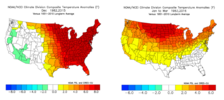
Oct 12 Winter 500.png


Oct 12 Winter T.png
 
Imho I think the gravy train gets going around the 2nd to last week of Jan to mid Feb. that’s statistically been the time to shine for the SE recently and given the long range strat forecasts/modeling of a weaker strat PV then normal around that timeframe, I’d put my 2 cents around that timeframe. Makes sense to if we crap away December with a strong low around Alaska/the Aleutians and the Bering sea, it’s gonna put some strain on the strat PV. Probably gonna be far more borderline/traditional setups that we are use to seeing then the gulf scraper and setups we’ve seen recently.
I agree, I think that’s a favorable pattern for our more CAD Miller B setups rather than the gulf scrapers. My concern here is with the -PDO increasing heights over the northeast as it destructively interferes with our canonical ENSO pattern.
 
I think a 1982-1983 / 2015-2016 blend is a pretty good 1st guess idea considering ENSO / QBO / Projected elevated Fall-Winter AAM. Warm Dec (*ducks & hides), then some bouts of winter mixed in during Jan-Mar

View attachment 198851


View attachment 198852
Keep in mind that in December, ENSO has less of an influence on North America weather. A strong ridge over the east coast is not a strong El Niño forced response (your second plot is).

For that reason, I wouldn’t say with confidence December is going to be a blowtorch. Off the top of my head, I can’t think of what other forces led to the warm December those years, but if anyone wants to dig into this, that might provide us some better insight on this year.

Maybe QBO?? I don’t really understand stratospheric dynamics that well.
 
Keep in mind that in December, ENSO has less of an influence on North America weather. A strong ridge over the east coast is not a strong El Niño forced response (your second plot is).

For that reason, I wouldn’t say with confidence December is going to be a blowtorch. Off the top of my head, I can’t think of what other forces led to the warm December those years, but if anyone wants to dig into this, that might provide us some better insight on this year.

Maybe QBO?? I don’t really understand stratospheric dynamics that well.
We do know that the Pacific jet goes nuts in early months of the winter in El Nino hence why the Pacific doesn't cooperate until January?
 
We do know that the Pacific jet goes nuts in early months of the winter in El Nino hence why the Pacific doesn't cooperate until January?
Not necessarily... The Pacific jet if it follows the ENSO forced response extends the jet and shifts it equatorward. The same as with geopotential height anomalies, ENSO just has less influence on the jet in December. However, there are several other sources of variability that can modulate the jet, such as MJO, East Asian Winter Monsoon, extratropical transition, that are unique to each season (and week).
 
Im cautiously optimistic that we will get it more east central based than far east based. I believe that would help our chances at colder outcomes. Tropical forcing is important. Not sure we will get there, but im hoping we will. Timing is of an essence
 
Keep in mind that in December, ENSO has less of an influence on North America weather. A strong ridge over the east coast is not a strong El Niño forced response (your second plot is).

For that reason, I wouldn’t say with confidence December is going to be a blowtorch. Off the top of my head, I can’t think of what other forces led to the warm December those years, but if anyone wants to dig into this, that might provide us some better insight on this year.

Maybe QBO?? I don’t really understand stratospheric dynamics that well.

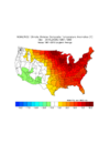
Yes, the best 5 +QBO Dec/Nino analogs all are clearly mild in Dec in the E US overall. In the SE 4 of 5 are mild (15, 82, 87, 06) while only 57 wasn’t as it was near normal in just the SE:

IMG_2905.png
 
Back
Top