• Hello, please take a minute to check out our awesome content, contributed by the wonderful members of our community. We hope you'll add your own thoughts and opinions by making a free account!

Wintry Winter 26-27

Well at least it did snow here more than once (I'm looking at you last year!) but none of them were that great either. Several advisory level snows

Oh and we had a tornado on Christmas Eve morning in 1982! That's fantastic

Somehow it's still better than 15-16 or 97-98 though
Our best chance maybe only will be mid January to early mid February . This Nino is really amping up to be historic strong
 
Still waiting for us to go below normal for more than 12 hours...

It's gonna be at least 10 more days. If we're lucky

Average high will be in the 60s by Halloween btw which right now Accuweather is still above normal then!

I think this is still a major problem I'm having with the winter hype


Further bad news is that WB CFS maps are cold biased in much of the E US. I studied some maps recently and found them to be 4F too cold in much of the E US vs the CFS site’s own output. There are major algo issues with WB CFS maps. If you go to the actual CFS site, you’ll of course see the real output.
 
Last edited:
Further bad news is that WB CFS maps are cold biased in much of the E US. I studied some maps recently and found them to be 4F too cold in much of the E US vs the CFS site’s own output. There are major algo issues with WB CFS maps. If you go to the actual CFS site, you’ll of course see the real output.
These models will soon correct there selves when it picks up on the super Nino as we move closer to winter .
 
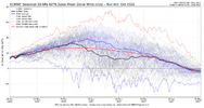
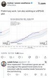
Euro Seasonal from Oct 5 showing Strat PV weaker than normal for Jan-Feb compared to 1958-2025 climo (solid blue line) and weaker than normal compared to past runs of the model from 1995-2025 (solid red line). That's a good look from the model if true

View attachment 198527
You think we just see a ragged stretched out PV or one where it comes down whole kit and kooboodle,changes zipcodes from NP to Canada or northern Asia. Its in a stretched out version right now on its 1st of many appearances this winter. kinda just fumbeling around the NP/ like fujiwara/ dumbelling.
 
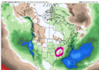
Strong El Niño climo favors drier than normal in that area as it’s too far away from the progged very strong ST jet that’s causing in the SE.
Thanks, it just threw me off because it is surrounded by the light green slightly above normal precip on all sides, increasing as you move further E.
 
Still waiting for us to go below normal for more than 12 hours...

It's gonna be at least 10 more days. If we're lucky

Average high will be in the 60s by Halloween btw which right now Accuweather is still above normal then!

I think this is still a major problem I'm having with the winter hype
Yep. Avg high here on Halloween is 58-59. Coldest so far this season is 45. Saturday looking like 84
 
These models will soon correct there selves when it picks up on the super Nino as we move closer to winter .

My point wasn’t at all to say that the CFS is too cold (or too warm). Obviously nobody knows how the CFS will do. Rather, my point is that the WB CFS maps don’t accurately represent the actual CFS output due to algo issues. For accurate CFS output, go to the CFS site here:


From the link above, here’s the latest REAL 10 day avg of JFM: keep in mind that this is vs 1991-2020 climo (I’ll address that later):
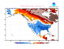
IMG_2842.png


Now here’s the faulty algo ridden WB 10 day for the same period: keep in mind that this is vs 1981-2010 climo (I’ll address that later):
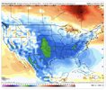
IMG_2840.jpeg

Observations:

1. The real CFS output doesn’t have that ever-present WB CFS cold spot over S Lake Michigan.

2. The real CFS output doesn’t have that ever-present WB CFS thin warm area along the E coast Mid-Atlantic to SE states.

3. The WB CFS output is significantly colder than the real CFS output for most of the E US away from the E coast and for the C US. Note how much further N the blues go on WB!

Examples:
-Chicago: WB CFS has them at -2C using 1981-2010 vs the real CFS’ 0C using 1991-2020. That means WB CFS output is ~4.5F too warm vs the real CFS output. Keep in mind that 1991-2020 is ~1F warmer than 1981-2010 and thus is incorporated in my analysis.

-St. Louis: WB CFS: -3C (1981-2010) vs real CFS’ ~-1C (1991-2020). So, WB is again ~4.5F too warm.

-Tulsa: WB CFS: -4C (1981-2010) vs real CFS’ of an estimate via interpolation of -2.2C (1991-2020). So, WB is ~4F too warm.

-ATL: WB CFS: ~-3.5C (1981-2010) vs real CFS’ est via interp. of -2.3C (91-20). So, WB is ~3F too warm.

-RDU: WB CFS: ~-1.2C (81-10) vs real CFS’ -2.3C (91-20). So, WB is ~3F too warm.


Now, as I said, WB has a thin warm area along/near much of the E coast. That actually causes some of that area to be correct on WB.

-SAV and JAX: WB CFS: -1.5C (81-10) vs real CFS’ -2C (91-20). So, WB is actually correct.

 
Latest tweet from ole Judah. Says the slow start to snowcover up top means a mild winter on the way.

View attachment 198551
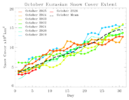
Low numbers now, but the forecasted snow advance looks promising based on Urals ridging and snow in E Asia. Differing opinions on how to use this stuff, but I like to keep it simple - high snow advance across Eurasia and northern latitudes (good), weak snow advance (bad)

IMG_5516.jpeg
 
What in the name of heck is this? Sometimes you got to laugh at Accuweather
8971f889ec8a9686393287209705f6e5.jpg


Sent from my iPhone using Tapatalk
 
You think we just see a ragged stretched out PV or one where it comes down whole kit and kooboodle,changes zipcodes from NP to Canada or northern Asia. Its in a stretched out version right now on its 1st of many appearances this winter. kinda just fumbeling around the NP/ like fujiwara/ dumbelling.
Here are all Ninos with at least 1 tri-monthly anomaly of +2.0 or higher. SSW in late Jan of 1973 is only SSW of the 4 years. A combined AO/NAO index shows 9 of the 16 months solidly positive, only 3 of 16 months solidly negative. Charlotte temperatures shown against the year's 30 yr avg. Dec favored warm, Jan cool. Jan-Feb looks solid for cool temps outside of 97-98. I'd say a low chance that both Dec and Jan are cold / below normal. Looking at the lower Strat charts (100mb), 97-98 had a weakened SPV in early and mid-winter, 15-16 had a weakened SPV in mid-winter, and 82-83 had a weakened SPV in mid-late winter. +QBO this year is more similar to 15-16 and 82-83, matching up with the ideas for the SPV in the Euro Seasonal forecast chart.

Oct 7 Sup Nino.png
 
Can anyone explain/theorize this dry area where TN/AR/MO/KY meet?

View attachment 198536
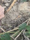
It’s bad. I live in middle Tennessee and have a farm in western ky. So I’m ground zero at both places. This was wheat planted two weeks ago. Just sitting on dust. We did get a rain last Friday that helped, but dry again all week, and hopefully we get a drought buster from the hurricane
And when we get dry late in the summer the deer are susceptible to a disease transferred from a biting midge called EHD. A telltale sign is they die by water because they run such a high fever they are looking to cool off. Unfortunately found one last weekend. For everyone you find who knows how many you don’t. Bad way to go. As unpleasant as drought is for us, it’s deadly for wildlife.

IMG_3471.jpeg
IMG_3569.jpeg
 
It’s bad. I live in middle Tennessee and have a farm in western ky. So I’m ground zero at both places. This was wheat planted two weeks ago. Just sitting on dust. We did get a rain last Friday that helped, but dry again all week, and hopefully we get a drought buster from the hurricane
And when we get dry late in the summer the deer are susceptible to a disease transferred from a biting midge called EHD. A telltale sign is they die by water because they run such a high fever they are looking to cool off. Unfortunately found one last weekend. For everyone you find who knows how many you don’t. Bad way to go. As unpleasant as drought is for us, it’s deadly for wildlife.

Sounds like us in eastern SC/NC back in the spring. Lots of farmers had to plant tobacco twice because it didn't rain for over 30 days in these parts. It all died in the fields. Corn was ankle high until after Memorial Day.
 
JB,
So there is certainly a link to a colder starting El nino season with the late hurricanes. And again, why not? If you have this MJO at this time of the year the same kind of feedback in Nov/Dec, especially that period from Thanksgiving to Christmas, should produce a cold result


I think there are a alot of rough edges this winter that will impact the final product. And there is no question that simply saying its a strong el nino, game, set, match, has merit ( please understand, to those who blowtorch much of the winter, I am NOT SAYING YOU ARE WRONG) I think there are other things of note that argue that it may not be that simple

This could be one of them I believe it will. We won't know it till later

After all, those who know what they know don't know what they ought to know

And as I said that includes me
 
JB,
So there is certainly a link to a colder starting El nino season with the late hurricanes. And again, why not? If you have this MJO at this time of the year the same kind of feedback in Nov/Dec, especially that period from Thanksgiving to Christmas, should produce a cold result


I think there are a alot of rough edges this winter that will impact the final product. And there is no question that simply saying its a strong el nino, game, set, match, has merit ( please understand, to those who blowtorch much of the winter, I am NOT SAYING YOU ARE WRONG) I think there are other things of note that argue that it may not be that simple

This could be one of them I believe it will. We won't know it till later

After all, those who know what they know don't know what they ought to know

And as I said that includes me
Even ole JB comes up with a solution. During a Nino which will pass strong . Trying get those gists subscription s up. He knows he may need them …
 
Even ole JB comes up with a solution. During a Nino which will pass strong . Trying get those gists subscription s up. He knows he may need them …
As I have said being a snow/ice contractor for 35 years, never believe it when people say this is going be a great winter, maybe epic, or we have never seen anything like it. I have not heard JB say that yet for this year but many others have. When the major hype starts normally its the opposite or no where what people thought, at least for us here in NC. As always we will be ready but will believe all the predicted hype when I see it.
 
Latest SST's. The Atlantic is gonna start off the winter season AN. Just nothing showing up in the coffers to upwell/ take out the heat. This suposedly bodes well for better Blocking / getting the AO and NAO into negative phases. We shall see.
On the Pacific side, you can see the kelvin wave working its way up off the Baja / now on the coast of CA. This should end up off the NW Coast Oregon/WA/ Vancover perhaps couple weeks.How this/ or if this will affect our sensible wx I have no clue.
Seeing the NW PAC still AN and Im not sure helps us get a more favorable PDO outcome. Suprised from all the east Pac Hurricanes = Upwelling there isnt really any blue showing up north of the el nino strip. My opinion is Ocean temps/ espeacilly Pacific are the main forces that drive wx patterns or start the chain reaction affect.


From AI:

Short-to-Medium Term Forecast Outlook
  • Persistence of Phase: Multi-model ensemble regression forecasts indicate the PDO will remain locked in this negative phase through late 2026 and into early 2027. Long-range climate models project a very slow evolution toward neutral, but any transition to a warm/positive PDO (+PDO) is highly suppressed by the current spatial footprint. [1, 2, 3]
  • Anomalous Interaction: Most historically strong El Niño events occur while the PDO is in a positive phase. This rare clash—a Super El Niño colliding with a cold -PDO—is introducing unique atmospheric mechanics for the upcoming winter. [1]
  • Expected Impacts (Winter 2026-2027): The persistent -PDO cold pool northeast of Hawaii will combine with the intense equatorial heat to warp the jet stream. Rather than a standard El Niño setup, forecasts project a heavily boosted atmospheric river regime. This is expected to push frequent, severe storms and heavy flooding rainfall into California, while simultaneously driving a secondary storm track across the U.S. Sun Belt from Florida up through the Mid-Atlantic. [1, 2]
 
Last edited:
As I have said being a snow/ice contractor for 35 years, never believe it when people say this is going be a great winter, maybe epic, or we have never seen anything like it. I have not heard JB say that yet for this year but many others have. When the major hype starts normally its the opposite or no where what people thought, at least for us here in NC. As always we will be ready but will believe all the predicted hype when I see it.
Well said , the hype on this winter has been been almost comical …still say our best chance will be when Nino begins to relax late January into mid February
 
Snowbobby and this guy, say it’s gonna be a blockbuster winter! I have many doubts about that!IMG_6718.jpeg
 
As I have said being a snow/ice contractor for 35 years, never believe it when people say this is going be a great winter, maybe epic, or we have never seen anything like it. I have not heard JB say that yet for this year but many others have. When the major hype starts normally its the opposite or no where what people thought, at least for us here in NC. As always we will be ready but will believe all the predicted hype when I see it.

Literally heard on the radio this morning what a wild winter it's gonna be

I turned it off

Besides everything that is hyped up here is never what everyone says. Even the snowstorm in January paled in comparison to the models and posts I saw all week

I'm not trying to be negative but I'm so sick of the hype
 
Last edited:
Literally heard on the radio this morning what a wild winter it's gonna be

I turned it off

Besides everything that is hyped up here is never what everyone says. Even the snowstorm in January paled in comparison to the models and posts I saw all week

I'm not trying to be negative but I'm so sick of the hype
100 perfect t agree with you . Think most of the media really knows what we are heading towards this winter . Trying get clicks n more clicks . That’s what’s all about
 
We are likely to be below normal in parts of the SE this winter, but IMO it will be a wet winter and all the rains we get frequently will be the cause ,not many arctic blasts. I would look for more ice than snow in the traditional ice areas
 
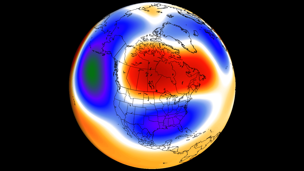
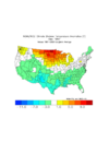
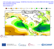
Copernicus model average for Jan-Feb-Mar. Model avg from Euro, UK, France, Canada, Germany, USA, Japan

Models are hell bent on following a strong El Nino, split-flow pattern. Are they correct? Hard to say, but with Super Nino and high AAM currently entrenched, I would lean that way.

I think a key this winter with this pattern is keeping the reds out of Ohio and Pennsylvania and keeping the blues out of Alaska and Vancouver - better chance of that mid-late winter than early winter

Oct 10 JFM 500.png
 
Back
Top