Downeastnc
Member
How much snow in the Greenville, NC area so far? Seems like it’s been dumping there for hours and hours
13-15" 2-4 ft drifts...
How much snow in the Greenville, NC area so far? Seems like it’s been dumping there for hours and hours
Someone needs to let the storm know that snow is suppose to end here around 2am lol....radar says we will lucky if it stops by dawn.
It was brutal all day fighting that dry slot but we are getting a backend thump for surePouring snow
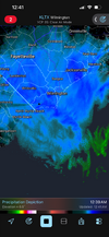
Look at the Atlantic moisture making its way west. It’s gotten so far west it seems to be close to interacting with the Charlotte metro area. Take a look at these two screenshots. First is the CoCo from Greenville radar and the second is from Raleigh. I’m no student of meteorology but it seems to me as they get closer together it would generate a blossoming of precipitation in the eastern parts of the Charlotte metro area.
View attachment 193106View attachment 193107

It was brutal all day fighting that dry slot but we are getting a backend thump for sure
Starting to believe the hrrr is on to something. Heaviest s ow of the night here and flakes are getting big. With decent ratios we could still get some crazy totals.This band looks wild from Oak Island up to Lake Waccamaw. Almost stationary and expanding its width.


How much snow in the Greenville, NC area so far? Seems like it’s been dumping there for hours and hours
Starting to believe the hrrr is on to something. Heaviest s ow of the night here and flakes are getting big. With decent ratios we could still get some crazy totals.
I’m almost certainly at 5 pushing 6 right nowHrrr still going ham on us overnight View attachment 193101
Starting to believe the hrrr is on to something. Heaviest s ow of the night here and flakes are getting big. With decent ratios we could still get some crazy totals.


It could go out with somewhat of a bang if these returns from the Concord/Matthews band would work a couple of miles to the west.I've been up this long and got nowhere to go tomorrow with all this snow on the ground. I'd like to stay up until the snowfall fades away in CLT.
It’s gonna snow longer than I can stay up
 yep. I have several long driveways to clear tomorrow for people and if I don't keep mine at least marginally clear tonight it's going to be a giant pain tomorrow. These are all partially shaded with pines and will turn into a glacier tomorrow night if they aren't cleared in the morning so the sun can dry them off.
4 in Wilmington even after the dry slot we sat through
4 in Wilmington even after the dry slot we sat through

I don’t think HCS will be back until Wednesday at this point,Ed Piotrowski saying another 2-5" across the area tonight. Lots of us in NESC/SENC are making a run at 10" it seems. I can't believe how hard it's snowing.
I don’t think HCS will be back until Wednesday at this point,
2 or 3 from what I saw earlier.How’d Columbia do?