HailCore
Member
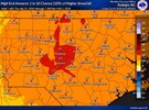
Updated FFC snowfall totals for north and central GA: 

i expected 0 snow from this and i end up in a 2-3" zone ill take itUpdated FFC snowfall totals for north and central GA: View attachment 191285

 This is before the EURO so I wouldn't be surprised to start seeing them continue to increase
Is that taken at face or add some for ratios?Yeah the parallel NBM looks much more realistic with this storm over NC for the moment and is closer to what I’d probably forecast.
General 3-6” or so area wide, with 2 snow maxes. One snow max i am pretty confident in from around Charlotte and just west and south into the upstate of SC and northern midlands. The other one over the coastal plain which has a higher risk, high reward involved and could shift as far west or north as Raleigh or so depending on how this evolves the next day or so
View attachment 191283
Hard to pin down for sure. RAH and WTVD both going with twice that amount here right now.Yeah the parallel NBM looks much more realistic with this storm over NC for the moment and is closer to what I’d probably forecast.
General 3-6” or so area wide, with 2 snow maxes. One snow max i am pretty confident in from around Charlotte and just west and south into the upstate of SC and northern midlands. The other one over the coastal plain which has a higher risk, high reward involved and could shift as far west or north as Raleigh or so depending on how this evolves the next day or so
View attachment 191283
I think we're also gonna break Highway 12, yet againwouldn't be shocked to see some blizzard watches for dare county/va beach in the afternoon package
That has been discontinuedwouldn't be shocked to see some blizzard watches for dare county/va beach in the afternoon package
I'm not even getting attached to this look but dang.. that band is right over my backyard in Athens. Kind of lowkey impressed how this has trended today. Still time for it to jog a little east and north though.Dream setup. Peepaw type snowstorm if we can hold onView attachment 191274
state's going to have some hard conversations about that highway in the next decade or soI think we're also gonna break Highway 12, yet again

Looks identical to the weathernext totals the last 2 days

lol how yall going to measure your totals with that dry snow blowing around? Be 2-3’ drifts in places and bare ground in othersGSP now has charlottes forecast as blowing snow sat, insane!
Wow! Huge increase up there.


.png")
Feels like we should be using 2 separate trend gifs for AIFS - one for 00/12 and one for 06/18 as that wobble makes it impossible to actually compare.
Moving closer to the AIFS solution thereWell, the 12z eps isnt matching up with the op very well. Drier across the board. Lots of nuances with this one.
View attachment 191293
To the roof with an X-large pizza of your choice!
Not terrible, at least (widespread 5-10" for most of NC / SC). The ensembles are ran at a lower resolution, right? Wonder if they could be missing some of the mesoscale features as a result? Or perhaps this is wishcasting.Well, the 12z eps isnt matching up with the op very well. Drier across the board. Lots of nuances with this one.
View attachment 191293
It is SO SO strange how the 18z/6z runs have been so different from the 12z/0z runs. Don't typically see the jumpiness like that.. and it is across the board-- all models that initialize with ECMWF are having this. Even AIFS-ENS and WeatherNext.Feels like we should be using 2 separate trend gifs for AIFS - one for 00/12 and one for 06/18 as that wobble makes it impossible to actually compare.
You know maybe it’s a coincidence but looking that map, it’s got me roughly at 7.33”. The latest Hourly graphs that GSP has at my location is for a storm total of 7.1”6z WeatherNext2 was a doozy
View attachment 191251
For this location, yes.Wow! I know everyone here is super pumped for you guys in the midlands of SC, you have all been so snake bitten. I believe a 5-8” event there in Columbia, SC would be the biggest storm since February 2010?!
Well, it’s a blessing and a curse. If you’re in a subsidence zone you will be very disappointedNot terrible, at least (widespread 5-10" for most of NC / SC). The ensembles are ran at a lower resolution, right? Wonder if they could be missing some of the mesoscale features as a result? Or perhaps this is wishcasting.

Well, the 12z eps isnt matching up with the op very well. Drier across the board. Lots of nuances with this one.
View attachment 191293
Outside of the Blizzard warning that was issued short notice in March 1993, I don’t know that I have ever seen blowing snow in CLT’s forecastGSP now has charlottes forecast as blowing snow sat, insane!