That's the upcoming HRRR replacement right? Hmmm...Old RUFUS is coming in clutch!

-
Hello, please take a minute to check out our awesome content, contributed by the wonderful members of our community. We hope you'll add your own thoughts and opinions by making a free account!
You are using an out of date browser. It may not display this or other websites correctly.
You should upgrade or use an alternative browser.
You should upgrade or use an alternative browser.
Wintry Machine Learning Mauler 1/30-2/1
- Thread starter SD
- Start date
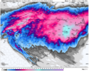
That placement, screams throwing qpf galore up this way, but its at 500mb. If surface lp could stack underneath it at that location. It would be a sightThat small closed contour in the middle..View attachment 191185
NWS knows ball 
GeorgiaGirl
Member
That's the upcoming HRRR replacement right? Hmmm...
I think it's replacing the NAM, and from what I've seen, it's not really useful either in its long range, hah.
We finally found an RGEM run that I'm not a huge fan of, ha. I'd really like one of the good bands to set up on me.
Wasn't this blanking us yesterday? Seems useful, but glad to have it on our side now, at least.Old RUFUS is coming in clutch!
ForsythSnow
Moderator
With everything else coming West it seems to have the right idea of the precip shield being in GA for quite awhile. We will need to see how the FGEN sets upI think it's replacing the NAM, and from what I've seen, it's not really useful either in its long range, hah.
We finally found an RGEM run that I'm not a huge fan of, ha. I'd really like one of the good bands to set up on me.
Brandon10
Member
IK a lot of people dog the RRFS, me included, but the radar depiction from hour 60 and on looks much more realistic for a coastal developing that closs minus all the dry gaps. Yes, we are going to have a dry slot, but that should be west, not in the deform band
In GSP latest disco
With the pressure gradient tightening on the west side of
developing, strong coastal low, gusty winds will develop across
the region on Saturday, with gusts of 25-30 mph likely...resulting
in some areas of blowing snow, and possibly brief, localized
blizzard-like conditions. The precip will taper off Saturday
evening, leaving behind the coldest air mass of the year...nay
one of the coldest air masses we`ve seen in a while.
I'm hoping for a smooth transfer between the upper level low and the coastal low. That would alleviate some of the concerns about the dry slot and give us all some good QPF numbers and snow totals.

really hoping that i can pick up 1 or 2in from thisWith everything else coming West it seems to have the right idea of the precip shield being in GA for quite awhile. We will need to see how the FGEN sets up
- Joined
- Jan 23, 2021
- Messages
- 4,603
- Reaction score
- 15,199
- Location
- Lebanon Township, Durham County NC

billyweather
Member
This is a 10:1 correct?
Thanks for the correction. I do know the RGEM scores well at closer rangesI think it's replacing the NAM, and from what I've seen, it's not really useful either in its long range, hah.
We finally found an RGEM run that I'm not a huge fan of, ha. I'd really like one of the good bands to set up on me.
Blue_Ridge_Escarpment
Member
The next update will most likely shift west and bump up. NBM is a cycle behind.
saielA10462
Member

Thank you roofus, surely you won’t fold like a camping tent?
EmilyWx
Member
While there remains a lot of uncertainty about the upcoming forecast, one thing is for sure: road and surface temperatures are going to be VERY cold during the event. Accumulation should begin quickly for those that see snow. Especially with high snow ratios snow will be very efficient in accumulating and thus the slightest increase/decrease in QPF values can make a huge difference in the forecast. In addition with prolonged cold air following this system, snow will likely have a hard time melting at all for some areas. Dangerous wind chills and hazardous travel remains very likely for many areas.
Edward Nygma
Member
It too shifted toward the Gulf Stream track scenario.Still going . . . Can't believe this thing was showing a dusting for most of the SE yesterday. lol.
View attachment 191208

rufus is what happens when the low bombs in the area you'd expect it to bomb given the synoptics lol
Tarheel17
Member
Wild how big of a boom/bust potential there is for the Triangle and points NE within 48 hrs.
One camp = dry slot
Other camp = best storm in years
One camp = dry slot
Other camp = best storm in years
blueheronNC
Member
RRFS shows that same dry slot, but then the coastal gets going enough that it rages snow all the way back through the Triangle. This event may be one where during the day Saturday gives everyone heart attacks being dryslotted but then it magically fills in after dark. Or it doesn’t if it’s the NAM solution. Cardiac times.I'm hoping for a smooth transfer between the upper level low and the coastal low. That would alleviate some of the concerns about the dry slot and give us all some good QPF numbers and snow totals.
Brads latest vlog says he sees a lot of red flags with dry air and he is pessimistic on the higher totals some are showing. 2-5” but can bust with just an inch, boom is 8”
- Joined
- Jan 23, 2021
- Messages
- 4,603
- Reaction score
- 15,199
- Location
- Lebanon Township, Durham County NC
It is a Kuchera mapThis is a 10:1 correct?
Webberweather53
Meteorologist
At this very moment, the only area I would feel safe about my forecast is the upstate of SC back to Charlotte and maybe the mountains, (hence my earlier post a little bit ago). Outside of that? Yeah I honestly don’t know 
WxBlue
Meteorologist
Seems like stronger ULL = more coastal track = better widespread totals. Comparing the NAM with the RRFS.
Cary_Snow95
Member
GFS is going to be worse. More positive tilt so far
What's left of the dry slot on the RRFS. Would still have to lean towards the better-known models, but who knows with this setup.

Parts of eastern/southern Wake County get 18". I would gladly take my 11" of snow. **notice how I made sure to say "of snow" haha.
Parts of eastern/southern Wake County get 18". I would gladly take my 11" of snow. **notice how I made sure to say "of snow" haha.
iGRXY
Member
GFS is going to be worse. More positive tilt so far

It's better not worse thru 39
It looks like the dry slot is going to end up west of Raleigh. The original low is going to be weaker than the low that forms off the coast. That’s my thought..
Webberweather53
Meteorologist
The TPV is slowing up just a bit on the gfs the last 3-4 runs. RDU folks need that desperately
packfan98
Moderator
AIGFS is good for SC. Crappy for much of NC.

AIGFS is good for SC. Crappy for much of NC.
View attachment 191218
Its been on this for a couple of days...I thought it was an outlier...but its leading. Will remember this one for a long time...good chance Raleigh gets completely blanked. Would be so funny.
We don’t like this?
rburrel2
Member
It's a dream 5h low track for the upstate... Further south and west with it than the hi-res models.AIGFS is good for SC. Crappy for much of NC.
View attachment 191218
Still lots of time but .46 of an inch with ratios better than 10:1 would equal more than I have seen personally since 2014 when I was at Lejeune!AIGFS is good for SC. Crappy for much of NC.
View attachment 191218
packfan98
Moderator
GFS is looking good for western NC so far.

BrickTamland
Member
GFS looks like it's filling in nicely to me.