Blue_Ridge_Escarpment
Member
Looks like it still likes the ULL in WNC
Looks like it still likes the ULL in WNC
sure, but less than it did in prior runs and has been a steady trend drier. to be clear i'm not burying this one, but let's get a positive trend on an accurate modelLooks like it still likes the ULL in WNC

That's a legit movement from a model that's usually very locked in by now
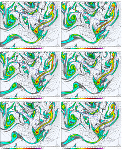
This. You can't look at this H5 trend and tell me this isn't close to a bomb.Phased Miller A bombs like what may be coming this weekend have so many moving pieces to them that they all have to be in the right spot and in the right orientation to make it work properly.
Models, even the AI ones, are probably too underdispersed in how they’re handling everything
I remember Dec 2010 went from amped to then looking more suppressed at some point in the medium range only to make a hellacious comeback inside day 3. Long ways to go with this one

Yeah the AIFS is probably the most encouraging reliable piece of guidance at the moment. EPS/AIFS-ENS/WxN seems to be the way to go, but even that grouping has notable disagreement at this junctureThis. You can't look at this H5 trend and tell me this isn't close to a bomb.
View attachment 189906
According to AI the models maybe locked in falsely and missing something important due to too much noise. I wonder if we will get recon flights?In the thread I posted above, Tomer mentions that with TPVs, models will be under dispersed and struggle to resolve small changes.
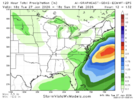
Hopefully would be a little higher ratio than 10:1, anyway it does give us wiggle room if it starts to tick back W. Seems it was locked in last week but iirc it did tick NW last 48 hrs. As long as it doesn't whiff completely before it starts to do that. Whiff is definitely a possibilityI’d take 2” and be very happy…hopefully it starts windshield wiping today
View attachment 189902
Hopefully would be a little higher ratio than 10:1, anyway it does give us wiggle room if it starts to tick back W. Seems it was locked in last week but iirc it did tick NW last 48 hrs. As long as it doesn't whiff completely before it starts to do that. Whiff is definitely a possibility
Yeah we need a bombing coastal in just the right spot like the CMC was showing.Yeah...I am no longer worried about any sort of west trend with this one...
A victory for us would be a 1-3" event board wide...I would take that in a heartbeat and call it a winter. Atleast for Raleigh, we don't do big snowfalls anymore, they never work.
Encouraged to see there’s still a path forward at least around here even if this thing scoots ots.00z Ai Graphcast was a rburrel/mitch mauler.
Looks like a whiff for Raleigh
View attachment 189917View attachment 189918
00z Ai Graphcast was a rburrel/mitch mauler.
Looks like a whiff for Raleigh
View attachment 189917View attachment 189918


Yea even the euro gives us something.Encouraged to see there’s still a path forward ant least around here even if this thing scoots ots.
i believe so. Bouncycorn said last year the Graphcast has decent verification scores. The fourcast, not so good.Is the model above you showed this one below? I never knew what this even was...
View attachment 189919
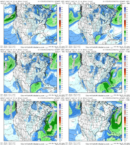
And I don't know what this one is either...but it's a bomb
View attachment 189920
WPC
Sent from my iPhone using Tapatalk
Yeah I would not want to be a forecaster for this one.... the public is already itching to make you guys look bad after this last stormeuro camp is a real bummer. it is nice to have the bomb camp occupied by a diverse set of models but that doesn't really give me decision making confidence
I think Cary hits on the main trend here. Geographically, we’ve trended better for NC/SC, but we’ve lost storm intensity in some cases. But mainly at this point, we need to avoid the awful scenarios (Euro Op / Icon)One thing that has appeared since the 00z runs is the orientation of the footprint has changed from more SSW-NNE to more SW-NE. Less into the northeast and further backing the footprint over the Carolina’s and into Georgia slightly
i think the NBM is a useful "centering" tool, especially when there's broad consensus, but the flipside is that it will keep accumulations residually high well after there's firm evidence that we're getting rug-pulled, which what the euro is trying to do now.The NBM seems much more in line with what I expect out of these coastal storms. Granted those west of the coastal plains are going to be more iffy.
As we saw last January these lows love riding the thermal gradient caused by the Gulf Stream. Yea in some cases they can scoot east towards Bermuda but that’s way less common.
