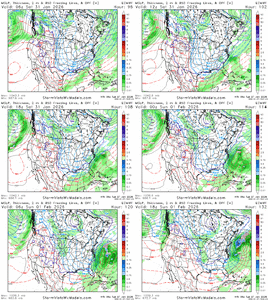
Can someone tell the hamster on the euro wheel to put some pep in his step dear lord
-
Hello, please take a minute to check out our awesome content, contributed by the wonderful members of our community. We hope you'll add your own thoughts and opinions by making a free account!
You are using an out of date browser. It may not display this or other websites correctly.
You should upgrade or use an alternative browser.
You should upgrade or use an alternative browser.
Misc General Banter Thread
- Thread starter Rain Cold
- Start date
According to Kylo, it still is heading further East.Can someone tell the hamster on the euro wheel to put some pep in his step dear lord
everyone should just go home and look at the models again on thursdayAccording to Kylo, it still is heading further East.
rburrel2
Member
I’m not even a little concerned about the euro.
Euro ai, gfs ai, weathernext all on top of each other and two of the 3 have been trending better.
The euro won’t score a victory here.
Euro ai, gfs ai, weathernext all on top of each other and two of the 3 have been trending better.
The euro won’t score a victory here.
The all mighty weathernext has been trending east for like 8 runs now. It had a lot of Alabama in a 1-2 inch range just a couple days ago. Godspeed to those of yall to the east. I hope it doesn’t go OTS but this is just fitting for what we all deal with every time. Such a painful hobbby
znel52
Member
6z Euro was a morale crusher. I want a coastal crusher not a morale crusher.
Bigedd09
Member
Icon better not be the new king lol
Sent from my iPhone using Tapatalk
Sent from my iPhone using Tapatalk
znel52
Member
Next Google is at 8am correct? We need to stop the bleeding. I don't have high hopes though.
High in the mid 20s here Saturday, 
Coldest week in years and I got to see some dandruff flakes yesterday. Great hobby here
Turkey season can’t come soon enough. Gatlinburg isn’t even getting good snow so far this year.
Coldest week in years and I got to see some dandruff flakes yesterday. Great hobby here
Turkey season can’t come soon enough. Gatlinburg isn’t even getting good snow so far this year.
Brent
Member
High in the mid 20s here Saturday,
Coldest week in years and I got to see some dandruff flakes yesterday. Great hobby here
Turkey season can’t come soon enough. Gatlinburg isn’t even getting good snow so far this year.
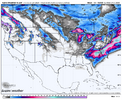
I saw this yesterday. It's crazy. I'm looking at the snowy spots I went on vacation last few years... There's no snow! I mean look at Salt Lake City and Boise!!!
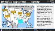
Bigedd09
Member
Stick a fork in it smh . Congrats Germans
Sent from my iPhone using Tapatalk
Sent from my iPhone using Tapatalk
znel52
Member
Google with another decrease. It's hard to go against Google and Euro. Just hope it doesn't trend to a nothing burger. Give me a few flakes.
Snowflowxxl
Member
People were getting excited over the CMC. It had me getting to 67 last weekend with severe storms 
packfan98
Moderator
It will be interesting to see where we are at after the 12z runs tomorrow. I wouldn’t think there would be too much wiggle room after that.
Bigedd09
Member
It’s quite evident that we are most likely losing our coastal. We need to hope and pray for some upper level low magic. Often times models do underestimate upper level lows
Sent from my iPhone using Tapatalk
Sent from my iPhone using Tapatalk
Gulp
So apparently CPC is now using RONI for ENSO starting on February 1st. https://www.weather.gov/media/notification/pdf_2026/pns26-05_Relative_ONI.pdf
Bigedd09
Member
Another brutal Tuesday for model runs. Last Tuesday started losing it amped and north…this week we are losing it progressively east. But…it’s a quick death so that nice.
View attachment 189905
Hard to win around here smh
Sent from my iPhone using Tapatalk
LovingGulfLows
Member
- Joined
- Jan 5, 2017
- Messages
- 1,499
- Reaction score
- 4,100
People were getting excited over the CMC. It had me getting to 67 last weekend with severe storms
Yeah we have to remember the CMC and UK were really far north/amped with the last system...UK in particular was egregiously amped before trending back south. I don't know...models are just so hard to trust right now.
Anyways, looking more and more like Atlanta might be out completely but ill give it until probably 12z tomorrow.
znel52
Member
Wasting this level of cold would be a gut punch. Let's hope this is just windshield wiping like some are saying.
I’m calling the authorities
People are gonna be coming at Kylo with pitchforks. I’m out of hopium, sometimes you gotta look in the mirror and look at the past. Stupid!
Cbmatt2408
Member
It's time. Go ahead and transition to tornado season. We know that won't miss us.High in the mid 20s here Saturday,
Coldest week in years and I got to see some dandruff flakes yesterday. Great hobby here
Turkey season can’t come soon enough. Gatlinburg isn’t even getting good snow so far this year.
a_gilmore88
Member
We are so due for a bombed out Miller A working for us that I almost feel like this is destined to come back. Maybe not, but goodness gracious why can’t we have anything nice.
Weenie mode engaged:We are so due for a bombed out Miller A working for us that I almost feel like this is destined to come back. Maybe not, but goodness gracious why can’t we have anything nice.
The big ones always trend away at this point and then come back nw
broken025
Member
This is all Brick’s fault
GeorgiaGirl
Member
Phased Miller A bombs like what may be coming this weekend have so many moving pieces to them that they all have to be in the right spot and in the right orientation to make it work properly.
Models, even the AI ones, are probably too underdispersed in how they’re handling everything
I remember Dec 2010 went from amped to then looking more suppressed at some point in the medium range only to make a hellacious comeback inside day 3. Long ways to go with this one
Yeah, it's going to be tough for me to do so with me not getting my normal sleep/maybe getting sick? but it might be best to just sit tight here for now.
I remember that bust pretty well still. Now granted my location was somewhere else from here on a Christmas trip we cut short (unrelated to the snow) and this probably can't come back to getting them this time (NW GA).
a_gilmore88
Member
Weenie mode engaged:
The big ones always trend away at this point and then come back nw
You kid, but it’s not all that untrue. Almost all storms are “lost” in mid-range modeling before making a valiant comeback to one degree or another. And as has been discussed, this one has a ton of moving parts that are difficult to resolve. It may well be a snowstorm for the fish, but I am not writing it off yet.
Yep, just scares me google has steadily trended east the last 5-6 cycles.You kid, but it’s not all that untrue. Almost all storms are “lost” in mid-range modeling before making a valiant comeback to one degree or another. And as has been discussed, this one has a ton of moving parts that are difficult to resolve. It may well be a snowstorm for the fish, but I am not writing it off yet.
Noles1812
Member
I look forward to hot days. Winters have been awful cold the last few years down here.
Man you can't be serious? All the heartbreak you've experienced over the last few years in the upstate and you still never give up. I admire you for that. But believe me, the Euro/ EPS can be on an island and be correct. It doesnt do well with CAD that's true. But it did nail the overall storm track last week at this range and those 60s and 70s surging north that nobody believed. This isn't in the same ballpark as that setup so it very well can be right here. If other guidance shifts to it today we're cooked.I’m not even a little concerned about the euro.
Euro ai, gfs ai, weathernext all on top of each other and two of the 3 have been trending better.
The euro won’t score a victory here.
Doesn't matter how good the pattern is or how cold it is. The sad truth is for the last 4 years we have a whole inch of sleet in the books. I'm well beyond frustrated at this point. It is ridiculous
Honestly I can't think of a storm that hasn't had a blip/worse trend at some point in a 7-day window before go time. Christmas storm was OTS for days before it ticked back west. I don't think it showed snow west of 95 until 48 hours out. Not saying this will trend better/is the same situation, but it was a Miller A also
It will only snow in Raleigh, if not cast the death of all winter storms from here on out!
disassociated_vort
Member


