Snowflowxxl
Member
Thunder ice definitely on the menu for some

Both...the heaviest of the ice will be Northeast of the city. We will see ice then turn to rain if the CAD erodes quick, which is never the case. I think the GFS/ICON are overdoing the totals though.
You'd better hope the RGEM is handling the wedge correctly. It's another prolific QPF producer. It's been said to handle CAD well. We will see. Underestimating the staying power of such a strong CAD is a dangerous game.Both...the heaviest of the ice will be Northeast of the city. We will see ice then turn to rain if the CAD erodes quick, which is never the case. I think the GFS/ICON are overdoing the totals though.

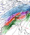
Surprised it’s not a little more south-- all the way in on ice
View attachment 188029
Not challenging your expertise here with respect to CAD and I believe it too. However would you also say this event is presenting a goliath amp warm nose as well. Big battle going on?In the past the models are always a step ahead of themselves eroding the CAD too fast. This is about as strong of a CAD you will ever see and I just can't imagine it eroding quickly. With that said, with heavy freezing rain and latent heat release, this may aid somewhat where the heaviest of liquid precip occurs.
Wonder if FFC will maybe go Ice Storm Warning for Fulton County (Atlanta). Think it’s issued when there’s a greater than 80% chance .25” or more. Most recent graphic I saw had Atlanta at 73%.
North Fulton likely has higher odds. Anyone know when the last ice storm warning was for Atlanta?
For the Feb 2014 storm, I believe a Winter Storm Warning was issued. You got a little bit of everything with that storm. I still lived in the city at the time and remember the wedge rolling in with sleet & zr...After a dry slot, a cold core low moved in & dropped between 2 & 4 inches of snow.Maybe Feb 2014.
Because well it's the GFSThe GFS has carried the way this whole storm. Why stop believing now?
Yes, you are correct but at the same time this is a MASSIVE CAD. Only time will tell but I never bet against the CAD....just saying.Not challenging your expertise here with respect to CAD and I believe it too. However would you also say this event is presenting a goliath amp warm nose as well. Big battle going on?
Nope/ hard to believe with it that cold. The warm nose is so fat. Probbaly getting clear / refroze rain drops at that hour/ pinging off the ground. almost gets back to -10 at last second.Is that not a sleet sounding on the 2nd graph at 54hrs??
Had some in Randolph county via word of mouth for a short periodSleeting in Cary

That's SC for you. actually farther east in my area.At this point the storm should start by February 5thView attachment 188012
Did I argue against it?@jackendrickwx what is your argument against more sleet and more zr at least for the upstate?
RGEM spares Atlanta. NE burbs, smoked.
You'd better hope the RGEM is handling the wedge correctly. It's another prolific QPF producer. It's been said to handle CAD well. We will see. Underestimating the staying power of such a strong CAD is a dangerous game. View attachment 188030
That looks like a Ice Storm Warning will be needed for the counties with more than .50 inch of ice accrual. This is not encouraging news.NWS has updated and increased ice accumulation
Sent from my iPhone using Tapatalk
It will weaken it and melt it some but depending on accretion amounts, it likely doesn’t wash it all away.Does anyone have any thoughts on what happens when we start as ZR and transition to rain at the end of a storm? Will the rain wash away the ice on trees and roads will be fine until we drop below freezing again Sunday night? Or does it not work like that? Specifically referring to the ATL area. Can’t remember any ZR to rain storms in recent years
Keep in mind yesterday's map ended at 7 am Sunday and today's map pushed it back 24 hours. This was yesterday's map for 3 days.NWS has updated and increased ice accumulation
Sent from my iPhone using Tapatalk

Yeah so it’s still in the range because they are both til 7am Monday. But they did up their expected amounts from 1:40am. That’s probably what he’s talking aboutKeep in mind yesterday's map ended at 7 am Sunday and today's map pushed it back 24 hours. This was yesterday's map for 3 days.
View attachment 188050
The problem is. It’s possible the damage will have already been done. If the tree/power line has already fallen, it can melt, but it’s still on the ground. Let’s just hope the lighter precip models win.Does anyone have any thoughts on what happens when we start as ZR and transition to rain at the end of a storm? Will the rain wash away the ice on trees and roads will be fine until we drop below freezing again Sunday night? Or does it not work like that? Specifically referring to the ATL area. Can’t remember any ZR to rain storms in recent years
You read my simple mind perfectly. The uptick in amounts was what I was referring to.Yeah so it’s still in the range because they are both til 7am Monday. But they did up their expected amounts from 1:40am. That’s probably what he’s talking about
Any melting before the strong NW winds kick in Monday morning will be quite helpful.The problem is. It’s possible the damage will have already been done. If the tree/power line has already fallen, it can melt, but it’s still on the ground. Let’s just hope the lighter precip models win.
Keep in mind yesterday's map ended at 7 am Sunday and today's map pushed it back 24 hours. This was yesterday's map for 3 days.
View attachment 188050


Canadian with less ICE and less qdf
View attachment 188060View attachment 188062View attachment 188064
This was issued at 1am this morning.Yeah, I was more talking about the change from the one they put out this morning this one…
Sent from my iPhone using Tapatalk
Total qpf for Raleigh increased with this run. It went from 1.0 to 1.4
Sent from my iPhone using Tapatalk
It’s supposed to be pretty windy during the zr event too, no? But yes, grateful for any and all the help to mitigate. Need power. 8 degrees and no power will be miserable.Any melting before the strong NW winds kick in Monday morning will be quite helpful.
This was issued at 1am this morning.


That looks like warning criteria for the entire state except east of 95. Impressive.