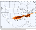
i’m only 3.14”. You can come stay at my house it might be marginally safer?3.3 inches of freezing rain jackpot for me with temps in the low to mid 20s. yay?
View attachment 187315
-
Hello, please take a minute to check out our awesome content, contributed by the wonderful members of our community. We hope you'll add your own thoughts and opinions by making a free account!
You are using an out of date browser. It may not display this or other websites correctly.
You should upgrade or use an alternative browser.
You should upgrade or use an alternative browser.
Wintry January 23rd-27th 2026
- Thread starter SD
- Start date
GFS/Icon roughly the same general idea of a big I-20 north frz rain window
FV-HRW out to 60 :/ was actually looking pretty dang good(Along with the WRF Meso
RGEM/NAM: Same general Idea with AL/GA.Carolinas of cutting and some CAD frz into the CAD regions Carolinas and GA
Any Sampling on GFS made relative little different seemed to pretty much stay on track there but someone put a balloon up on in Canada and figure out where that N. Stream is and where is it actually going!!!
ForsythSnow
Moderator
I sure do love being in the 2" bullseye of horror. I really hope some tiny change at verification leads to it being mostly sleet instead
Catfish
Member
Pretty sure that Winter Storm Watch will need to be extended southward to include all of metro ATL.
ChattaVOL
Member
I get 1.18 of ice then 2 more inches of cold rain lolFinal freezing rain total…just a casual almost 3 inches for ATL lol
View attachment 187316
- Joined
- Jan 23, 2021
- Messages
- 4,604
- Reaction score
- 15,203
- Location
- Lebanon Township, Durham County NC
The biggest ice storm red flag for me would’ve been the short range modeling showing an early transition. I think we’ve stopped the bleeding IMBY with freezing rain tonight and maybe even gained some ground in having the vast majority of QPF being sleet.
beanskip
Member
I know everybody is operating under the assumption that this QPF number are overdone, esp. when its in the teens/low 20s.
But, what if they aren actually close. I've been in an ice storm when .5 inches of liquid basically led to 100 percent power outages. 2 inches is just insane.
But, what if they aren actually close. I've been in an ice storm when .5 inches of liquid basically led to 100 percent power outages. 2 inches is just insane.
CMC looks like a slightly stronger cold press out ahead so far
If it makes you feel better it’s just the GFS/ICON and how often do they win?I sure do love being in the 2" bullseye of horror. I really hope some tiny change at verification leads to it being mostly sleet instead
Agree. Ive not given up quick front thump, but not getting hopes up. Need to see sleet map off gfs, if one exist.Yeh we’re gonna get a concrete job. Question is if we can sneak a 3-5 front end thump of snow first before the pour starts. Honestly that will be tons of fun.
Sent from my iPhone using Tapatalk
All about qpf . Do we get 1.5 - 2.0? If so, we could easily end up with a half a foot of sleet.
Are these little disturbances in MT and ND
Doing anything to round two of the storm? The interaction!??
Doing anything to round two of the storm? The interaction!??
Last edited:

- Joined
- Jan 23, 2021
- Messages
- 4,604
- Reaction score
- 15,203
- Location
- Lebanon Township, Durham County NC
I would be the most scared of a catastrophic ice event between say US 64 and I-20. Frankly, we’ve never, in so far as I can ever remember, had freezing rain around twenty. That’s like some of those Quebec ice events.I know everybody is operating under the assumption that this QPF number are overdone, esp. when its in the teens/low 20s.
But, what if they aren actually close. I've been in an ice storm when .5 inches of liquid basically led to 100 percent power outages. 2 inches is just insane.
Webberweather53
Meteorologist
The GFS is becoming just borderline useless, and not just for tropical cyclones either. I swear this model has honestly gotten worse over the last several months. Most recent run completely caved to the Euro camp (shocker I know)


2014 Augusta crusher? Masters destroyer??I would be the most scared of a catastrophic ice event between say US 64 and I-20. Frankly, we’ve never, in so far as I can ever remember, had freezing rain around twenty. That’s like some of those Quebec ice events.
You got a sleet map off gfs by chance?The biggest ice storm red flag for me would’ve been the short range modeling showing an early transition. I think we’ve stopped the bleeding IMBY with freezing rain tonight and maybe even gained some ground in having the vast majority of QPF being sleet.
Rain just started falling here at the house.
Anyway take a step back. If this were a summer storm system which blend of models would you be using for precip totals? Bc that’s really all that matters now
Anyway take a step back. If this were a summer storm system which blend of models would you be using for precip totals? Bc that’s really all that matters now
Its showing way more ice than the Euro though for ATLThe GFS is becoming just borderline useless, and not just for tropical cyclones either. I swear this model has honestly gotten worse over the last several months. Most recent run completely caved to the Euro camp (shocker I know)
You got a sleet map off gfs by chance?

Attachments
- Joined
- Jan 23, 2021
- Messages
- 4,604
- Reaction score
- 15,203
- Location
- Lebanon Township, Durham County NC

iGRXY
Member
Finished with almost 5” of sleet and almost an inch of FRAM ZR on that run. The upstate crew on this board better go ahead and accept we are getting somewhere in the neighborhood of 3-5” of sleet and likely 0.75-1.25” of ZR on top of it. The far western upstate was well over an inch of ice on the FRAM.
iGRXY
Member
speed:

This is terrifying
This is terrifying
WolfpackHomer91
Member
That’s honestly badass lol
 like 4-6” Sleet with 1/2”-1” ICE top with temps at like 22 very nice
 Sent from my iPhone using Tapatalk
You may never see modeled temps like this again at this range for the Carolinas

I remember when the GFS would print these out at hr312 and we’d all have a good laugh. Nobody is laughing now
HailCore
Member

ZR totals from the Canadian appear to have increased for parts of NE GA, probably because this run actually hung on to the CAD for longer which is is more believable than the Euro completely erasing it after a short time IMO. Obviously these totals are overdone because QPF and Canadian, but I don't see this threat going away anytime soon for those regions.


Makeitsnow
Member
Same here. It's nauseating knowing what's coming. Unfortunately though each run has dissolved super cold 925mb temps sunday meaning everyone changes to freezing rain late sat night..early sun. Unless we see a drastic change we are screwed.I know everybody is operating under the assumption that this QPF number are overdone, esp. when its in the teens/low 20s.
But, what if they aren actually close. I've been in an ice storm when .5 inches of liquid basically led to 100 percent power outages. 2 inches is just insane.
David chandley on fox 5, who is a well respected atlanta met just said it could be a "generational ice storm". He doesn't say things like that lightly imo. The only thing that could save us at this point is a)a sudden shift of the axix of heavy precip north or b) we see a colder solutions and we get sleet.
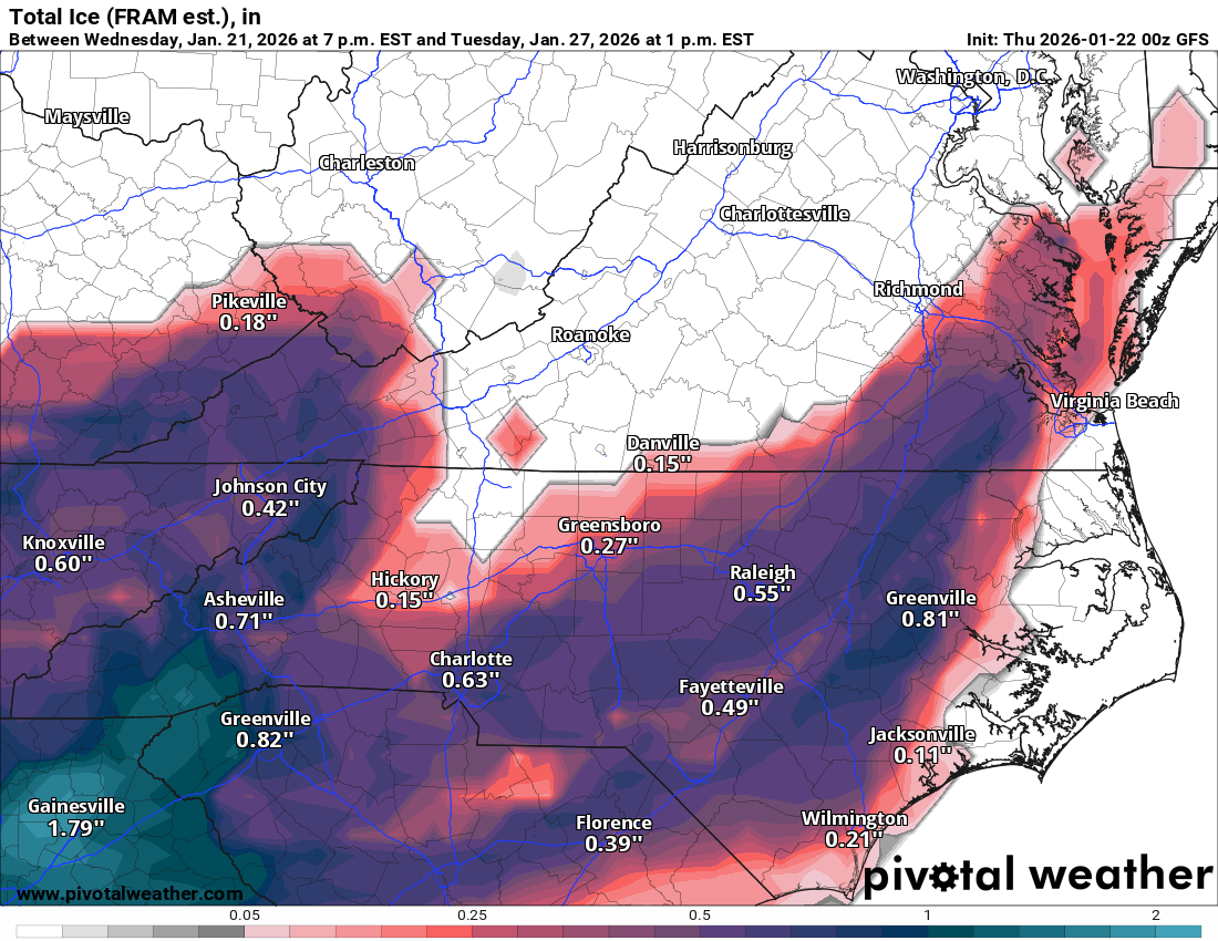
That is an absolute cave by the CMC to the GFS/Icon.View attachment 187328
ZR totals from the Canadian appear to have increased for parts of NE GA, probably because this run actually hung on to the CAD for longer which is is more believable than the Euro completely erasing it after a short time IMO. Obviously these totals are overdone because QPF and Canadian, but I don't see this threat going away anytime soon for those regions.
So 4 inches of sleet, followed up by .9 of FreeIng Rain. The highest the surface temp gets to as last drop falls is 26 degrees.
Knowing temps will be as advertised here. Lock
Its all about qpf total now. All have screamed 1.5+, some at or over 2.0 at times. The euro op has been outlier with its lowest output still at like 1.2 here.
Jimmy said it best,beat me to it. Its all about a qpf forecast now. Ive seen enough to know a major ice storm is coming. Triad south. Sleet will save us almost the whole 1st half of storm. But its second half we get scorched with frzng rain. You get below hwy 64, espeacilly down hwy 49 toward charlotte, uwharries, back toward pinehurst, down to Lake Hartwell GA, Gainsville, is gonna be rough.
- Joined
- Jan 23, 2021
- Messages
- 4,604
- Reaction score
- 15,203
- Location
- Lebanon Township, Durham County NC
I wonder if we’ll end up trending in the next 48 hours to a more significant front end thump of snow then a ton of sleet then some freezing rain only to be topped with more snow.
Just saying I’ve seen a ton of storms go like that.
Just saying I’ve seen a ton of storms go like that.
Atlanta is due for another 1973 event.
Looks like all the models are coming to a consensus except for the euro. The NWS even said this euro looks like an outlier so…

AIGFS is not nearly as cold in Georgia and is of a shorter duration with a much more amped look based solely on total precip.
For Georgia peeps who just want some pretty trees with minimal disruption, this one's for you.


For Georgia peeps who just want some pretty trees with minimal disruption, this one's for you.
Webberweather53
Meteorologist
1z NBM FRAM.
Quarter to half inch ice totals are a decent bet for many

Quarter to half inch ice totals are a decent bet for many
You may never see modeled temps like this again at this range for the Carolinas
View attachment 187329
I see no way that it will get as cold in ATL as is on this model. There’s got to be a problem with a GFS cold bias. How do they have much of ATL metro plunging to <0 with no snow or sleetcover? This looks way overdone. And did you see that run with all time record cold levels being surpassed?
WolfpackHomer91
Member
I wonder if we’ll end up trending in the next 48 hours to a more significant front end thump of snow then a ton of sleet then some freezing rain only to be topped with more snow.
Just saying I’ve seen a ton of storms go like that.
100%…. Maybe not to this extent but I swear this Day 2-3 timeframe with Feb 2014 was the same garbage about “ohhh Ice is the issue” then “Oh sleet bomb” then the last 24hrs it magically became deeper Cold. However I would only gotten like 9” from that, but I got in that insane ULL Deform that Thursday AM and legit got my last 3” from that
Sent from my iPhone using Tapatalk
was more of a “look at this crazy thing” post. I think there’s some merit to NC getting near 0 with rad cooling in the colder arctic airmass that settles in on Monday night with snowpack. Perhaps GFS sees ZR on the ground for ATL and takes it lunarI see no way that it will get as cold in ATL as is on this model. There’s got to be a problem with a GFS cold bias. How do they have much of ATL metro plunging to <0 with no snow or sleetcover? This looks way overdone. And did you see that run with all time record cold levels being surpassed?