tennessee storm
Member
When u dealing with this setup arctic air pushing Down with an active southern stream. Some will get screwed with ice as the air is more shallow
When u dealing with this setup arctic air pushing Down with an active southern stream. Some will get screwed with ice as the air is more shallow


30 and dropping in Acworth this morning. Crisp and dry *sigh*14 degrees here this morning and all indications are we could beat that at some point soon
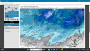
Latest 06Z run of the GEFS is showing a number of hits going into this upcoming weekend.
View attachment 184964View attachment 184965View attachment 184966View attachment 184967View attachment 184968View attachment 184969View attachment 184970
Yeah, this may be a good one to watch back our way!Yeah I may be dreaming or need sleep but the ensembles have improved every run here
Definitely have not seen that this winter here
Yeah, this may be a good one to watch back our way!
this is really early for them.png")
According to which models at which times? 18z, 0z. Etc…Good morning guys. Just catching up. Two possible threats starting next weekend? First one more mid-south?
Good morning guys. Just catching up. Two possible threats starting next weekend? First one more mid-south?
WelcomeHey everyone! New here, but I’ve been kind of lurking for a while just reading everyone’s posts but I figured I’d get a little more involved.
Super excited for the pattern coming up, especially in my north GA/metro ATL neck of the woods.
Sent from my iPhone using Tapatalk
Colder trend on the EPS leading into next weekend06z euro looks like it’s setting up for a major winter storm at hr144… cold air is still pressing south here… what an incredible look.
View attachment 184916View attachment 184917View attachment 184918


.gif")
Welcome to the forum! The next two weeks appear to be loaded with potential winter weather threats for practically everyone here. This upcoming period will be a fun one to watch. Let's all reel in a winter storm no matter our location by Groundhog Day.Hey everyone! New here, but I’ve been kind of lurking for a while just reading everyone’s posts but I figured I’d get a little more involved.
Super excited for the pattern coming up, especially in my north GA/metro ATL neck of the woods.
Sent from my iPhone using Tapatalk
We’re about 7-10 days away. It’s much too early to say anything specific about any areas beyond “there’s a good signal that maybe there might be a winter storm that might maybe affect the southeast”. Beyond that, you’ll have to wait and see.How does North Carolina look for this possible storm? Impressive look!


The first potential is definitely trending to a CAD event. Just toggle the last 3 runs on 2m temps.The gfs ai misses on the first storm… but is otherwise one of the most insane looking runs you’ll see. And hits on storm 2. And looks like it has a storm 3 taking shape for the gulf coast. 100 year type sustained cold with a massive high pressure dominating the entire run. Crazy stuff


Welcome to the familyHey everyone! New here, but I’ve been kind of lurking for a while just reading everyone’s posts but I figured I’d get a little more involved.
Super excited for the pattern coming up, especially in my north GA/metro ATL neck of the woods.
Sent from my iPhone using Tapatalk