• Hello, please take a minute to check out our awesome content, contributed by the wonderful members of our community. We hope you'll add your own thoughts and opinions by making a free account!

Jan. 17-18, 2026 SE Winter Weather Threat

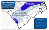
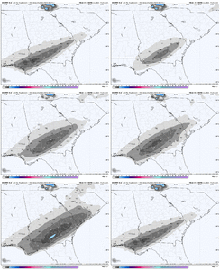
Allan’s First Map is out


18a4556dc5c89ea1880c1f8643048f3b.png


Sent from my iPhone using Tapatalk

Makes sense to me. I don’t expect to see much of anything accumulation wise in Carolinas, unless we pushed some heavier precip back towards the triad area and the western Piedmont/foothills. It’s just not cold enough east of there

Meanwhile, better access to cold air in GA is why they have at least a snowball’s chance in hell to see something. Down in GA, you’re closer to the surface high and the mountains aren’t blocking the initial cold push, unlike NC/SC. Also, the heavier precip moves thru in the morning down there, whereas it’s midday over NC. Just not doing anything right in the Carolinas
 
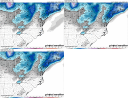
12z GEFS was a pretty nice jump NW. Grasping for straws here but it was noticeable. Someone with the weather bell graphics can post. Surprised it had not been posted yet.
As much as I want to hope, there is no way I can fully trust in that model after absolutely obliterating a 2-3 inch snowfall mean. However we will all end up right back in the same spot and I am surely going to be posting more GEFS data in a few days when we track the next system. Just need EPS and Euro support next time.
 
Makes sense to me. I don’t expect to see much of anything accumulation wise in Carolinas, unless we pushed some heavier precip back towards the triad area and the western Piedmont/foothills. It’s just not cold enough east of there

Meanwhile, better access to cold air in GA is why they have at least a snowball’s chance in hell to see something. Down in GA, you’re closer to the surface high and the mountains aren’t blocking the initial cold push, unlike NC/SC. Also, the heavier precip moves thru in the morning down there, whereas it’s midday over NC. Just not doing anything right in the Carolinas
Do you still think an under-modeling of the NW shield of precip is on the table, or probably not?
 
Do you still think an under-modeling of the NW shield of precip is on the table, or probably not?

There is always a risk of that in this kind of setup in the short-range. The synoptic changes in the northern stream (stronger and faster trailer trough) have kicked things east a bit and muted or even reversed the NW trend the last day or so

IMG_7277.png
 
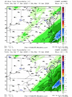
UKMET is a little further east, and other than some trivial snow in South Georgia, a nothingburger. Portends badly for Dr. No's entrance.

Thanks. The 12Z UKMET has a 2” max in far SW GA, which is quite a ways W of other model maxes in S GA. @accu35 you chasing if this were to verify? What about @deltadog03 , @GeorgiaGirl and others?

IMG_7183.png
 
alright well, first call. i prefer not to make a second call but the weenie in me hopes tonight and tomorrow's models force it, ha.

thinking precip starts earlier than modeled and further NW than modeled, but limited in the foothills by downsloping. could create a small overlap of sufficient cold to produce a mix and potentially allow for spotty dustings. small dusting area near Aiken SC as well, closer to the south GA accumulations region. think there will be plenty of rain and barely mixing in many places. even in the darker blue zone, i would expect lots of wet ground reports.

out east, i wouldn't fully rule out flakes flying, but temps make me think no at the moment

1768584151339.png
 
I’m sorry but I don’t think global and ensembles modes are the way to go at this point in the game


Sent from my iPhone using Tapatalk
 
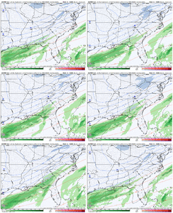
The coastal keeps flirting with coming closer to shore as it moves NE. Canadian’s been the only one really honking the horn for this though with consistency. NAM has always had it *just* missing Long Island, and RRFS even backed away back SE on alignment on its last run.

Hoping any trend with that alignment can help downstream as well and get NE NC and Richmond a little more help (except Moyock, it can snow anywhere but there)
 
I’m sorry but I don’t think global and ensembles modes are the way to go at this point in the game


Sent from my iPhone using Tapatalk
ensembles are wonderful here. they are made specifically for the situation at hand. the tilting and positioning of the trof and the energy flying around it needs to be slightly adjusted to get an overall idea of what is the most likely outcome in a very finicky setup

yes, even the sref is useful here at 500
 
the real question is how far it can push, we have to consider what the absolute most it can shift is
Adjustments will need to be made with the intial overrunning precip, not the coastal development. Unless you’re in the eastern parts of the forum
 
I-85 Corridor only needs one more NW jog. Should be easy to do, right??
If we were praying for no more nw jogs 60hrs out we would be nervous wrecks. I think we see continued shifts. I think Mitch up to the Hartsville Florence area is in a good spot.
 
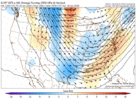
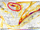
Essentially, we have less than 48 hours to make a small change in the depth/orientation of the vorticity racing across the South when it is in this position. As unlikely as any meaningful changes are likely to occur this close in, if we can just tuck that tail in a little, we would see a surprising uptick for many.
ecmwf_full-500hv-conus-2026011612-42.png
 
Essentially, we have less than 48 hours to make a small change in the depth/orientation of the vorticity racing across the South when it is in this position. As unlikely as any meaningful changes are likely to occur this close in, if we can just tuck that tail in a little, we would see a surprising uptick for many.
View attachment 184241
how far north do you think that could push the shield
 
Back
Top