Well not all of us.No it's all good. Just thought my comment was pretty straight forward and didn't know how it could be misinterpreted. We all need some snow
-
Hello, please take a minute to check out our awesome content, contributed by the wonderful members of our community. We hope you'll add your own thoughts and opinions by making a free account!
You are using an out of date browser. It may not display this or other websites correctly.
You should upgrade or use an alternative browser.
You should upgrade or use an alternative browser.
Wintry Midsouth Winter Storm January 12th-13th
- Thread starter Storm5
- Start date
Storm5
Member
Lol we just had a week straight where the impact areas for this system didn't get above 40 for over week. Ground temps wont be an issueYeah, like ground temps won't be an issue on a borderline event. GFS looks a little N
Sent from my SM-J320VPP using Tapatalk
Storm5
Member
Cmc is a hit
Sent from my SM-J320VPP using Tapatalk
Sent from my SM-J320VPP using Tapatalk
Blue_Ridge_Escarpment
Member
CMC has Memphis at 70 degrees Thursday afternoon.
Storm5
Member
Is there a point?CMC has Memphis at 70 degrees Thursday afternoon.
Sent from my SM-J320VPP using Tapatalk
Blue_Ridge_Escarpment
Member
Should help minimize road issues.Is there a point?
Sent from my SM-J320VPP using Tapatalk
NWMSGuy
Member
Temps before the Major 94 Ice Storm around these parts was around 70.
Storm5
Member
We had 60s for over a week straight before the snow in early December. All we we heard was ground temps will limit accumulation. That played out well....Temps before the Major 94 Ice Storm around these parts was around 70.
Ground temp argument is so overplayed
Sent from my SM-J320VPP using Tapatalk
MichaelJ
Member
Well here in theTriad, the snow took a long time to stick in early December and never did stick much on the roads. That was more likely due to rates though than ground temps I suspectWe had 60s for over a week straight before the snow in early December. All we we heard was ground temps will limit accumulation. That played out well....
Ground temp argument is so overplayed
Sent from my SM-J320VPP using Tapatalk
I think ground temps are a bigger issue in late Feb and March when you also have the sun angle working against you.
NWMSGuy
Member
CMC has snow for West TN and North MS at hour 54
Xtreme Weather
Member
As I mentioned last night looking at the 500mb level was to far E with the track of the LP and should be farther W and that is what we have seen on today's runs.
For those not in the wintry precip now vs what has been modeled last 24-48 hours what is needed s/w to close off (be stronger) and at the least go neutral to negative creating its own cold core and that puts the people further south in play...
All that said looks like W TN, N MS and maybe xtreme NW AL looking good... Nashville area I would be kinda concerned in regards to wintry precip and most of N AL. Yes could see some SN but I would not expect much unless like mentioned storm really deepens.
Edit I will try draw up an outlined area tonight when at home...i think most like to look at a map vs rambling on LoL
... Carry on
Sent from my iPhone using Tapatalk
Last edited:
JLL1973
Member
i knew it wasnt good being in the bullseye 3 days out. this system is headed I40 north
Usmeagle2005
Member
Snow just to my north, already had snow just to our south, usually sums up winter here. Alway just to the the north or just to the south, that 15 inch bulls eye for both systems was just a cruel joke. Loli knew it wasnt good being in the bullseye 3 days out. this system is headed I40 north
jaymackd3
Member
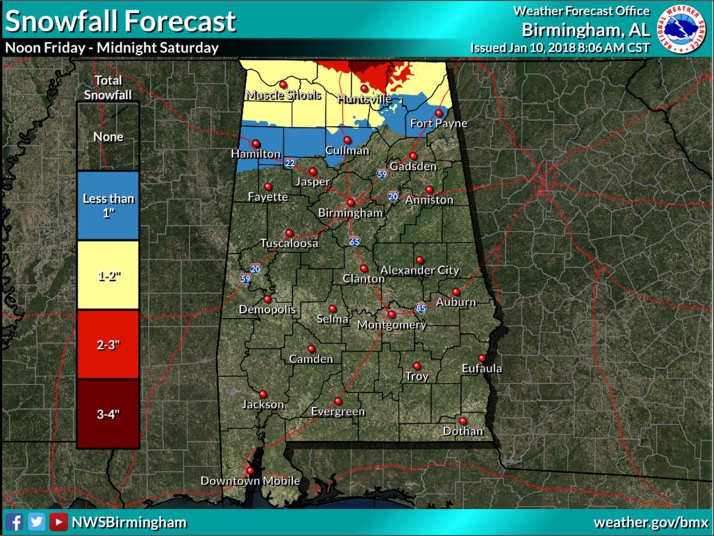
Why is the Birmingham NWS putting out a snow forecst for the Huntsville area ?
Storm5
Member
Gefs looks great for West Tennessee

Sent from my SM-J320VPP using Tapatalk

Sent from my SM-J320VPP using Tapatalk
jaymackd3
Member
beats me...it was posted on Spann's twitterWhy is the Birmingham NWS putting out a snow forecst for the Huntsville area ?
They apparently going with the euro.
Stormlover
Member
I'm sitting pretty in that..very close to the 3 to 4
Lol good grief ill be devestated if HUN gets snow and KCHA dont. Smh
Why are people acting like this is trending bad ??? This was never an ideal setup for Alabama , Georgia or east Tennessee. This has always been a good setup for northern Mississippi and West Tennessee. I think some people have unrealistic expectations of your SE of those areas. Things will change over the next 48 hours but this has always been a system that favors the NW parts of the region
Sent from my SM-J320VPP using Tapatalk
Absolutely. Everyone should have took that to the bank when I mentioned this threat a week ago. If I sniff it out, chances of snow in central AL plummet. I've got to be a pessimist to get snow here.
Storm5
Member
Euro is nasty for West Tennessee
Sent from my SM-J320VPP using Tapatalk
Sent from my SM-J320VPP using Tapatalk
Storm5
Member
Euro with freezing rain into Huntsville
Sent from my SM-J320VPP using Tapatalk
Sent from my SM-J320VPP using Tapatalk
Storm5
Member
Euro is much quicker. In and out 6 hours tops frozen for extreme Northern Alabama
Sent from my SM-J320VPP using Tapatalk
Sent from my SM-J320VPP using Tapatalk
Well guess it is game over!! LolEuro is much quicker. In and out 6 hours tops frozen for extreme Northern Alabama
Sent from my SM-J320VPP using Tapatalk
It was nice while it lasted. Lol.
JLL1973
Member
Storm what about north ms?Euro is much quicker. In and out 6 hours tops frozen for extreme Northern Alabama
Sent from my SM-J320VPP using Tapatalk
It is funny how fast this trended badly.
GeorgiaGirl
Member
Sounds like the GFS is about to coup a big time win, which is unreal, but then again, the Euro can be too phase happy.
The Euro still looks fine for North TN I feel but it's not that great anywhere else.
The Euro still looks fine for North TN I feel but it's not that great anywhere else.
jaymackd3
Member

Storm5
Member
This isnt really phase relatedSounds like the GFS is about to coup a big time win, which is unreal, but then again, the Euro can be too phase happy.
The Euro still looks fine for North TN I feel but it's not that great anywhere else.
Sent from my SM-J320VPP using Tapatalk
Storm5
Member
Some freezing rain verbatim this runStorm what about north ms?
Sent from my SM-J320VPP using Tapatalk
Stormlover
Member
Just seems odd that with cold air rushing in that it would be freezing rain in north ala like it shows. Not buying it, it will be a quick changeover to snow.Some freezing rain verbatim this run
Sent from my SM-J320VPP using Tapatalk
Storm5
Member
Surface temps crash but the warm nose at 850 could easily keep it as freezing rain or sleetJust seems odd that with cold air rushing in that it would be freezing rain in north ala like it shows. Not buying it, it will be a quick changeover to snow.
Sent from my SM-J320VPP using Tapatalk
If models are picking up on a warm nose now odds are it will become more prevalent as the event gets closerJust seems odd that with cold air rushing in that it would be freezing rain in north ala like it shows. Not buying it, it will be a quick changeover to snow.
NWMSGuy
Member
Looks like Memphis still expecting accumulating snow in their Hazardous Weather update issued at 11:52 AM
There is a potential for accumulating snow across portions of the
Midsouth early Friday morning through late Friday night. Rain
will transition to sleet and freezing before changing to snow.
Uncertainty remains with respect to location and magnitude of
winter precipitation.
There is a potential for accumulating snow across portions of the
Midsouth early Friday morning through late Friday night. Rain
will transition to sleet and freezing before changing to snow.
Uncertainty remains with respect to location and magnitude of
winter precipitation.
DadOfJax
Member
Dumpster fire for AL.....I think we may be done for! Dagnabbit!
Storm5
Member
Lol what??? This was never an Alabama threat. This has always been areas to our NW and extreme Northern AlabamaDumpster fire for AL.....I think we may be done for! Dagnabbit!
DadOfJax
Member
Lol what??? This was never an Alabama threat. This has always been areas to our NW and extreme Northern Alabama
Lol what???
Just because it isn't my backyard doesn't mean I don't pull for AL to get snow. It looked like some of us were going to cash in....now it doesn't. What am I missing?
Storm5
Member
I guess the fact that northern Alabama is very much still in playLol what???
Just because it isn't my backyard doesn't mean I don't pull for AL to get snow. It looked like some of us were going to cash in....now it doesn't. What am I missing?
Sent from my SM-J320VPP using Tapatalk