NBAcentel
Member
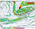
Doubt it honestly. With this type of setup it favors an overrunner type of system which usually doesn't favor our areas but for some reason we continue to see signs. Last overrunner to work here to my knowledge was 12/8/17.Gfs is probably over cooking the 2nd storm a tad but thermal profiles are there for an all snow event for the upstate. Consensus right now is more like .1-.2 of liquid though. I’m more concerned with precip than temps.(famous last words)
Dig to Mobile, transfer early, stay offshore of GA, and pivot the band over north GA.Dig straight south to Mobile and turn right
Sent from my iPhone using Tapatalk

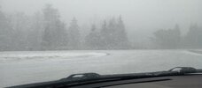
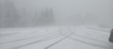
700mb cold core/vort max helping whip up some squalls this morning and graupel over the Foothills. Banner Elk was pretty much at whiteout a few minutes agoAlmost border line Blizzard Conditions now. Near zero visibility. Wind is ripping. Grandfather Mtn on the Parkway.


What is the difference between Kuchera and snow depth? I assume Kuchera a ratio based around liquid QPF (right?) but what data does snow depth use or is it literally just the depth of the snow? Does it consider the ratio variability on any given setup?Kuchera is much more accurate than snow depth

Looks fine to me!Second system is not as good as 6z on the new 12z GEFS. Lots to get sorted out before then.

Hard to get a good precip map for the second system, but from what I saw, it’s pretty dry.Not a bad
Looks fine to me! View attachment 182481

Looks more beef up further west.Hard to get a good precip map for the second system, but from what I saw, it’s pretty dry.
View attachment 182482


Both system dried upWelp 2.0 View attachment 182487
One factor I wonder is how well is AIFS able to handle such mesoscale features like this one has.
Just mean it's been consistent on a storm for some of us. Of course the amount/timing and exact location changes some, but it hasn't backed off.


AI runs off of zero physics is my understanding. So I have a hard time putting much faith in them. Course GFS, Gefs does run off physics and I have as equal less faith in them.One factor I wonder is how well is AIFS able to handle such mesoscale features like this one has.


NMB, I think what you're talking about. National Model Blend. Yeah, I'm not sure about AI yet either, don't really understand them. They may be great, but JB has shown many times how horrible they bust. He says there are no better than the physics models "yet," but sometimes he uses them if they show what he has been alluding to. He likes the model that shows what he thinks, he says. lolAI runs off of zero physics is my understanding. So I have a hard time putting much faith in them. Course GFS, Gefs does run off physics and I have as equal less faith in them.
Love to be corrected. But AI, reminds me of NBB or whatever the model is that crunches all physics models together


Apparently we can’t get a cutoff down past the Ohio valley anymore. Even with the really strong western ridge. Just doesn’t happen anymore. Generational run we are on for regular cornflakes branded weatherSucks we’re not going to take advantage of this. Was trending good but heading back the other way now
View attachment 182491
.png")