Good to see the NaM get onboard, certainly increases confidence we are not just staring at a unicorn less than 2 days out, with still some upside potential to trend toward a more meaningful event.
-
Hello, please take a minute to check out our awesome content, contributed by the wonderful members of our community. We hope you'll add your own thoughts and opinions by making a free account!
You are using an out of date browser. It may not display this or other websites correctly.
You should upgrade or use an alternative browser.
You should upgrade or use an alternative browser.
12/8/2025 Event - Repeat of Last Week?
- Thread starter packfan98
- Start date
if something like this 18z NAM verified, Wake would surely see something a bit more than what is showing here -- but be rest assured, the Raleigh and Charlotte snow holes can also be very real, history has shown us.I don’t buy the snow holes across state. If that’s the footprint, the holes will fill in
BrickTamland
Member
Hope to see the Euro to jump on board with the NAM and GFS. Just hard.for me not to be skeptical until then.
Twister
Member
How does it skip right over the Upstate and starts building in NC Piedmont??How the hell does the snow go around Wake County like that?
Tsappfrog20
Member
I would definitely take this
Sent from my iPhone using Tapatalk
Hopefully, we'll see a few more trends in the right direction. It would be nice for one of these to go our way for once.
LukeBarrette
im north of 90% of people on here so yeah
Meteorology Student
Member
2024 Supporter
2017-2023 Supporter
like clockworkI can already feel the NAM bomb coming in tomorrows runs
packfan98
Moderator
18z RGEM is juicing up too. Definite trend to more energy. Even getting some coastal enhancement going.


NBAcentel
Member
RGEM slowly getting there 
LukeBarrette
im north of 90% of people on here so yeah
Meteorology Student
Member
2024 Supporter
2017-2023 Supporter
ICON is not great to say the least. I would put a lot of stock in RGEM, my personal favorite with forecasting snowstorms and always seems to do a good job.
Bigedd09
Member
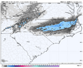
RGEM slowly getting there View attachment 178230
That’s very encouraging to see
Sent from my iPhone using Tapatalk
Trust me if that verified that's about the worst kick in the nuts u could possibly haveHow the hell does the snow go around Wake County like that?
Sent from my SM-S156V using Tapatalk
BrickTamland
Member
Another encouraging sign. NAM, GFS and RGEM looks pretty good for NC. Seems more of the models are going in the right direction for NC to see snow than the other way around. Euro is the big holdout.RGEM slowly getting there View attachment 178230
NBAcentel
Member
GFS continues to slowly getting better. The more moisture you can throw back the colder the surface gets 


packfan98
Moderator
Love the trends today!

BrickTamland
Member
GFS not backing down at all. Looking better than before, actually.
NBAcentel
Member
Man if we continue to do this, we would be talking about a more statewide deal, and a bigger deal at that. Get this pig to dig between bham and ATL 
rburrel2
Member
I feel like the best chance for a nuke job is Blacksburg to Roanoke since it seems like there may be some stationary banding features there with the vort passage . Plus they shouldn’t have much BL issues
NBAcentel
Member
Very encouraging to see the 20z HRRR continuing the slowing/digging in the C US vs its 18z run, if we do this until go time we might get a surprising event 
MichaelJ
Member
Don’t see a lot of difference in the outcome from yesterday’s event to this one. Probably another Va storm with perhaps some token flakes in northernmost North Carolina
Bigedd09
Member
Don’t see a lot of difference in the outcome from yesterday’s event to this one. Probably another Va storm with perhaps some token flakes in northernmost North Carolina
Disagreed. This is totally different. The upper levels will be much cooler
Sent from my iPhone using Tapatalk
Huge difference, this one actually has a cold air column in the upper levels combined with similar vorticityDon’t see a lot of difference in the outcome from yesterday’s event to this one. Probably another Va storm with perhaps some token flakes in northernmost North Carolina
Rule of thumb: if QPF is the limiting factor bets are it will overperform. If thermals are an issue, you’ll underperform.Don’t see a lot of difference in the outcome from yesterday’s event to this one. Probably another Va storm with perhaps some token flakes in northernmost North Carolina
Yesterday the snow was heavily warm air advection driven, and screwed up thermals with the warm nose… especially with poor climo and weak cold air damning, we were doomed from the start
This system does have cold chasing moisture, but the cold air gets pulled with more precipitation due to evaporative and dynamical cooling
I am a bit more confident that we’ll see some frozen precipitation with this one

packfan98
Moderator
18z Euro is improved as well.
NBAcentel
Member
Feels like we are heading towards something here….
wettest it's been so far18z Euro is improved as well.
NBAcentel
Member
AIFS looks better, also can see the increase in QPF causing lower surface temps 


BrickTamland
Member
UK and Euro both looking better and inching towards the GFS and NAM. I think the local mets might be changing their forecast tomorrow with 24 hours to go.
PRE HEAT THE OVEN.
GET THAT BEER. BUY THAT BREAD.PRE HEAT THE OVEN.
BrickTamland
Member
PRE HEAT THE OVEN.

this would be an impressive comeback if someone east of the mtns (kinda thinkin @RBR71 neck of the woods) manages more than like a 0.5" type deal. thought last week that this event looked interesting for some mountain snow, but if you can keep just nudging this vort back southwest, you're gonna help everything out. from pva/ult-induced precip to spawning a better sfc low off the coast to manufacturing cooler BL temps
NBAcentel
Member
Another uptick on the 18z AIFS ens 
NBAcentel
Member
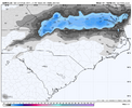
EPS 

BrickTamland
Member
WRAL met Chris Michaels posted this on Facebook an hour ago. But to me it looks like the models are showing more precip and dynamic cooling now, thus more of a chance for a decent snow event here.
Let me explain my thought process behind Monday. I'll start with nuts and bolts and then dig a little deeper, because I think you deserve that transparency.
And I think it's appropriate that a meteorologist talks some meteorology - which I'm seeing less and less of in recent years.
WHAT:
1. Some rain Monday morning with some sleet pellets/snowflakes mixing in later in the morning into the early afternoon hours north of I-40.
2. Any light accumulation would be just that. VERY light toward the Virginia state line and on the grass.
3. Any moisture Monday night/Tuesday morning will freeze as temperatures drop into the upper teens and 20s.
EXPLANATION:
1. First and foremost, it's not like we've got this honkin' system riding up from the Gulf with tons of moisture. The storm is going to have to manufacture its own moisture, which almost never bodes well for snow-lovers in our area.
2. Secondly, morning temperatures start above freezing and then temperatures drop during the day. As that happens, drier air intrudes from the north. So, your cold air and moisture aren't totally in sync.
So, for a few hours, you'll have snowflakes falling from the clouds and likely melting as they get closer to the "warmer" ground.
As the entire air column cools, you may get enough snow well after sunrise Monday to give us that little dusting toward the Virginia state line. Aside from that, it might just be a conversation starter for some folks north of I-40/I-85.
Cad Wedge NC
Member
It has more to do with speaking in absolutes as if the folks, who wish for snow and follow each model run leading up to an event, are inferior simpletons. There will always be busts both ways..... good and bad. Just my 2 cents.I honestly don't get the emotionality around this. If somebody like -- is constantly poo pooing snow but it happens and he ends up wrong, that's one thing. But if he is right most of the time, that isn't being a Debbie Downer. It's good forecasting.
Not a single person on this board, if they were forecasting professionally, would look at this upcoming event and be excited about anything more than mood flakes outside of the mountains and south of the VA border. The weather doesn't care how bad we want snow or how much we don't like people who don't forecast snow with every event.