-
Hello, please take a minute to check out our awesome content, contributed by the wonderful members of our community. We hope you'll add your own thoughts and opinions by making a free account!
You are using an out of date browser. It may not display this or other websites correctly.
You should upgrade or use an alternative browser.
You should upgrade or use an alternative browser.
Pattern Octoburn
- Thread starter SD
- Start date
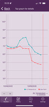
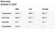
This is so beyond ridiculous. The temperature does not go from 84 to 88 in minutes and back and forth like that. This ---- is what is throwing off the 30 year averages
That's where the much maligned "data smoothing" comes in.
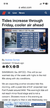
A 10.4 ft high tide is being forecasted for Ft. Pulaski for late Friday morning:
According to the following table, that would be tied for the 7th highest tide on record there going back ~90 years, tied with the 8/11/1940 hurricane. It would be only barely lower than the highest tide on record there not associated with a TC, which is the 10.45’ of 11/7/2021!
This is the longest coastal flooding discussion I can ever recall being released by KCHS:
TIDES/COASTAL FLOODING
THE FOLLOWING DISCUSSION IS FOR COASTAL CHARLESTON AND COLLETON
COUNTIES, ALONG WITH TIDAL BERKELEY COUNTY AS THEIR IMPACTS ARE
TIED TO THE CHARLESTON HARBOR TIDE GAGE, FOR THE REMAINDER OF
OUR SOUTHEAST COAST PLEASE SEE THE NEXT DISCUSSION. MAJOR
COASTAL FLOODING IS POSSIBLE THURSDAY MORNING AS KING TIDES
CONTINUE, WITH ASTRO TIDES OF 7.06 FT MLLW, WHICH BY ITSELF IS
ALREADY ABOVE MINOR FLOOD STAGE, TIDAL DEPARTURES OF 1 FOOT ARE
EXPECTED WHICH WILL BRING THE TIDE FORECAST OVER 8 FEET MLLW,
WITH THE CURRENT FORECAST AT 8.1 FT MLLW. AT THESE LEVELS,
WIDESPREAD AND HIGHLY IMPACTFUL COASTAL FLOODING OCCURS IN
DOWNTOWN CHARLESTON WITH NUMEROUS ROADS FLOODED AND IMPASSABLE
AND WATER ENTERING SOME STRUCTURES. IMPACTS ALSO INCLUDE EROSION
AT AREA BEACHES, WITH LIMITED TO NO ACCESS TO DOCKS, PIERS, AND
SOME ISLANDS. MAJOR FLOOD STAGE AT THE CHARLESTON HARBOR
RESULTS IN MINOR COASTAL FLOODING IN TIDAL BERKELEY COUNTY.
WHILE MODERATE COASTAL FLOODING IS AGAIN EXPECTED LATE THURSDAY
EVENING AS DEPARTURES RISE THROUGHOUT THE DAY AS STRONG
NORTHEASTERLY WINDS DEVELOP, WE ARE MOST CONCERNED FOR LATE
FRIDAY MORNING'S HIGH TIDE AS STRONG NORTHEAST WINDS CONTINUE
AND ASTRO TIDE FALLING TO JUST BELOW 7 FT MLLW, WHICH MAY AGAIN
RESULT IN MAJOR COASTAL FLOODING. THIS IS WHEN THE HIGHEST TIDE
IS EXPECTED AS DEPARTURES RISE TO NEAR 1.5 FT, WHICH SHOULD
BRING THE TIDE GAGE UP TO NEAR 8.5 FT MLLW. WHILE CONFIDENCE IS
HIGH IN MAJOR FLOOD STAGE BEING REACHED, MINOR FLUCTUATIONS IN
WIND DIRECTION AND WIND SPEED AROUND HIGH TIDE WILL ULTIMATELY
DETERMINE JUST HOW HIGH ABOVE 8 FEET WE GO, WITH NORTHEAST WINDS
RESULTING IN HIGHER READINGS ABOVE 8.5 FT MLLW AND MORE
NORTHERLY WINDS KEEPING US CLOSER TO 8.0 FT MLLW. IF WE WERE TO
REACH 8.5 FT MLLW, MODERATE COASTAL FLOODING IS EXPECTED IN
TIDAL BERKELEY COUNTY. FOR LATE FRIDAY EVENING THE ASTRO TIDE
DROPS TO 5.6 FT MLLW RESULTING MINOR/MODERATE COASTAL FLOODING
EXPECTED, WITH ANOTHER CHANCE FOR MAJOR COASTAL FLOODING LATE
SATURDAY MORNING INTO THE EARLY AFTERNOON HOURS AS ASTRO TIDE
PEAKS NEAR 6.72 FT MLLW, THOUGH WE'LL NEED TO SEE HOW THE TIDAL
DEPARTURES END UP TRENDING AS THE COASTAL LOW DEVELOPS TO OUR
SOUTH. DUE TO THE RISK OF MAJOR COASTAL FLOODING, A COASTAL
FLOOD WATCH HAS BEEN ISSUED FOR COASTAL CHARLESTON AND COLLETON
COUNTIES, VALID FROM 8 AM THURSDAY THROUGH 3 PM FRIDAY.
AT FORT PULASKI, WHICH IMPACTS AREAS FROM BEAUFORT COUNTY IN
SOUTH CAROLINA DOWN TO MCINTOSH COUNTY IN GEORGIA, LATE THURSDAY
MORNING'S ASTRONOMICAL TIDE OF 9.1 FT MLLW COMBINED WITH TIDAL
DEPARTURES OF JUST UNDER A FOOT WILL BRING THE AREA RIGHT TO
MODERATE FLOOD STAGE, WITH THE CURRENT FORECAST CRESTING AT 10
FT MLLW (MODERATE FLOOD STAGE). AT THESE LEVELS, HIGHWAY-80
CONNECTING TO TYBEE ISLAND STARTS TO SEE WATER ON IT AND
NUMEROUS ROADS BECOME IMPASSABLE SUCH AS SHIPYARD ROAD,
ISOLATING RESIDENTS ON BURNSIDE ISLAND.FLOODING WILL ALSO
IMPACT AREAS ON TYBEE ISLAND, WILMINGTON ISLAND, THE COFFEE
BLUFF COMMUNITY, OSSABAW ISLAND, SAPELO ISLAND, PORTIONS OF
HIGHWAY 17 SOUTH OF DARIEN. IN BRYAN COUNTY, WATER COULD BREACH
DOCKS NEAR FT MCALLISTER AND FLOODING IMPACTING PORTIONS OF MILL
HILL ROAD. IN LIBERTY COUNTY, FLOODING IMPACTS THE HALFMOON
LANDING AREA AND CATTLE HAMMOCK ROAD NEAR BERMUDA BLUFF
SUBDIVISION.
WE WILL LIKELY SEE MINOR COASTAL FLOODING LATE THURSDAY EVENING
AS ASTRO TIDE PEAKS AT 7.74 FT MLLW, WITH TIDAL DEPARTURES
RISING THROUGHOUT THE DAY CLOSE TO 2 FT. SIMILAR TO CHARLESTON,
THE TIDE OF GREATEST CONCERN OCCURS LATE FRIDAY MORNING, AS THE
ASTRO TIDE IS AT 8.91 FT MLLW AND WITH THE CONTINUED STRONG
GRADIENT WINDS ELEVATED TIDAL DEPARTURES IS EXPECTED. CURRENT
FORECAST PEAKS AT 10.4 FT MLLW, BUT AS DISCUSSED ABOVE, THE
EXACT WIND DIRECTION AND SPEED IS GOING TO PLAY A BIG ROLE IN
HOW HIGH ABOVE 10 FT MLLW THE TIDE GAGE WILL GO. IF THE WIND
DIRECTION WERE TO SHIFT CLOSER TO NORTHERLY, TIDAL READINGS
CLOSER TO 10 FT MLLW WOULD BE EXPECTED, WHEREAS NORTHEASTERLY
WINDS ARE CURRENTLY EXPECTED RESULTING IN THE FORECAST OF 10.4
FT MLLW. AS THE TIDAL READINGS APPROACH 10.5 FT MLLW, COASTAL
FLOODING IMPACTS EXPAND ALONG THE ENTIRE SOUTHEAST GEORGIA
COAST. WILL LIKELY SEE A BREAK FROM COASTAL FLOODING LATE FRIDAY
EVENING AS THE ASTRO TIDES FALLS TO 7.41 FT MLLW, THOUGH THERE
IS A RISK FOR ANOTHER ROUND OF MODERATE COASTAL FLOODING.
HOWEVER, AS MENTIONED ABOVE, WILL NEED TO SEE HOW THE TIDAL
DEPARTURES TREND AS THE COASTAL LOW DEVELOPS TO OUR SOUTH.
According to the following table, that would be tied for the 7th highest tide on record there going back ~90 years, tied with the 8/11/1940 hurricane. It would be only barely lower than the highest tide on record there not associated with a TC, which is the 10.45’ of 11/7/2021!

This is the longest coastal flooding discussion I can ever recall being released by KCHS:
TIDES/COASTAL FLOODING
THE FOLLOWING DISCUSSION IS FOR COASTAL CHARLESTON AND COLLETON
COUNTIES, ALONG WITH TIDAL BERKELEY COUNTY AS THEIR IMPACTS ARE
TIED TO THE CHARLESTON HARBOR TIDE GAGE, FOR THE REMAINDER OF
OUR SOUTHEAST COAST PLEASE SEE THE NEXT DISCUSSION. MAJOR
COASTAL FLOODING IS POSSIBLE THURSDAY MORNING AS KING TIDES
CONTINUE, WITH ASTRO TIDES OF 7.06 FT MLLW, WHICH BY ITSELF IS
ALREADY ABOVE MINOR FLOOD STAGE, TIDAL DEPARTURES OF 1 FOOT ARE
EXPECTED WHICH WILL BRING THE TIDE FORECAST OVER 8 FEET MLLW,
WITH THE CURRENT FORECAST AT 8.1 FT MLLW. AT THESE LEVELS,
WIDESPREAD AND HIGHLY IMPACTFUL COASTAL FLOODING OCCURS IN
DOWNTOWN CHARLESTON WITH NUMEROUS ROADS FLOODED AND IMPASSABLE
AND WATER ENTERING SOME STRUCTURES. IMPACTS ALSO INCLUDE EROSION
AT AREA BEACHES, WITH LIMITED TO NO ACCESS TO DOCKS, PIERS, AND
SOME ISLANDS. MAJOR FLOOD STAGE AT THE CHARLESTON HARBOR
RESULTS IN MINOR COASTAL FLOODING IN TIDAL BERKELEY COUNTY.
WHILE MODERATE COASTAL FLOODING IS AGAIN EXPECTED LATE THURSDAY
EVENING AS DEPARTURES RISE THROUGHOUT THE DAY AS STRONG
NORTHEASTERLY WINDS DEVELOP, WE ARE MOST CONCERNED FOR LATE
FRIDAY MORNING'S HIGH TIDE AS STRONG NORTHEAST WINDS CONTINUE
AND ASTRO TIDE FALLING TO JUST BELOW 7 FT MLLW, WHICH MAY AGAIN
RESULT IN MAJOR COASTAL FLOODING. THIS IS WHEN THE HIGHEST TIDE
IS EXPECTED AS DEPARTURES RISE TO NEAR 1.5 FT, WHICH SHOULD
BRING THE TIDE GAGE UP TO NEAR 8.5 FT MLLW. WHILE CONFIDENCE IS
HIGH IN MAJOR FLOOD STAGE BEING REACHED, MINOR FLUCTUATIONS IN
WIND DIRECTION AND WIND SPEED AROUND HIGH TIDE WILL ULTIMATELY
DETERMINE JUST HOW HIGH ABOVE 8 FEET WE GO, WITH NORTHEAST WINDS
RESULTING IN HIGHER READINGS ABOVE 8.5 FT MLLW AND MORE
NORTHERLY WINDS KEEPING US CLOSER TO 8.0 FT MLLW. IF WE WERE TO
REACH 8.5 FT MLLW, MODERATE COASTAL FLOODING IS EXPECTED IN
TIDAL BERKELEY COUNTY. FOR LATE FRIDAY EVENING THE ASTRO TIDE
DROPS TO 5.6 FT MLLW RESULTING MINOR/MODERATE COASTAL FLOODING
EXPECTED, WITH ANOTHER CHANCE FOR MAJOR COASTAL FLOODING LATE
SATURDAY MORNING INTO THE EARLY AFTERNOON HOURS AS ASTRO TIDE
PEAKS NEAR 6.72 FT MLLW, THOUGH WE'LL NEED TO SEE HOW THE TIDAL
DEPARTURES END UP TRENDING AS THE COASTAL LOW DEVELOPS TO OUR
SOUTH. DUE TO THE RISK OF MAJOR COASTAL FLOODING, A COASTAL
FLOOD WATCH HAS BEEN ISSUED FOR COASTAL CHARLESTON AND COLLETON
COUNTIES, VALID FROM 8 AM THURSDAY THROUGH 3 PM FRIDAY.
AT FORT PULASKI, WHICH IMPACTS AREAS FROM BEAUFORT COUNTY IN
SOUTH CAROLINA DOWN TO MCINTOSH COUNTY IN GEORGIA, LATE THURSDAY
MORNING'S ASTRONOMICAL TIDE OF 9.1 FT MLLW COMBINED WITH TIDAL
DEPARTURES OF JUST UNDER A FOOT WILL BRING THE AREA RIGHT TO
MODERATE FLOOD STAGE, WITH THE CURRENT FORECAST CRESTING AT 10
FT MLLW (MODERATE FLOOD STAGE). AT THESE LEVELS, HIGHWAY-80
CONNECTING TO TYBEE ISLAND STARTS TO SEE WATER ON IT AND
NUMEROUS ROADS BECOME IMPASSABLE SUCH AS SHIPYARD ROAD,
ISOLATING RESIDENTS ON BURNSIDE ISLAND.FLOODING WILL ALSO
IMPACT AREAS ON TYBEE ISLAND, WILMINGTON ISLAND, THE COFFEE
BLUFF COMMUNITY, OSSABAW ISLAND, SAPELO ISLAND, PORTIONS OF
HIGHWAY 17 SOUTH OF DARIEN. IN BRYAN COUNTY, WATER COULD BREACH
DOCKS NEAR FT MCALLISTER AND FLOODING IMPACTING PORTIONS OF MILL
HILL ROAD. IN LIBERTY COUNTY, FLOODING IMPACTS THE HALFMOON
LANDING AREA AND CATTLE HAMMOCK ROAD NEAR BERMUDA BLUFF
SUBDIVISION.
WE WILL LIKELY SEE MINOR COASTAL FLOODING LATE THURSDAY EVENING
AS ASTRO TIDE PEAKS AT 7.74 FT MLLW, WITH TIDAL DEPARTURES
RISING THROUGHOUT THE DAY CLOSE TO 2 FT. SIMILAR TO CHARLESTON,
THE TIDE OF GREATEST CONCERN OCCURS LATE FRIDAY MORNING, AS THE
ASTRO TIDE IS AT 8.91 FT MLLW AND WITH THE CONTINUED STRONG
GRADIENT WINDS ELEVATED TIDAL DEPARTURES IS EXPECTED. CURRENT
FORECAST PEAKS AT 10.4 FT MLLW, BUT AS DISCUSSED ABOVE, THE
EXACT WIND DIRECTION AND SPEED IS GOING TO PLAY A BIG ROLE IN
HOW HIGH ABOVE 10 FT MLLW THE TIDE GAGE WILL GO. IF THE WIND
DIRECTION WERE TO SHIFT CLOSER TO NORTHERLY, TIDAL READINGS
CLOSER TO 10 FT MLLW WOULD BE EXPECTED, WHEREAS NORTHEASTERLY
WINDS ARE CURRENTLY EXPECTED RESULTING IN THE FORECAST OF 10.4
FT MLLW. AS THE TIDAL READINGS APPROACH 10.5 FT MLLW, COASTAL
FLOODING IMPACTS EXPAND ALONG THE ENTIRE SOUTHEAST GEORGIA
COAST. WILL LIKELY SEE A BREAK FROM COASTAL FLOODING LATE FRIDAY
EVENING AS THE ASTRO TIDES FALLS TO 7.41 FT MLLW, THOUGH THERE
IS A RISK FOR ANOTHER ROUND OF MODERATE COASTAL FLOODING.
HOWEVER, AS MENTIONED ABOVE, WILL NEED TO SEE HOW THE TIDAL
DEPARTURES TREND AS THE COASTAL LOW DEVELOPS TO OUR SOUTH.
Last edited:
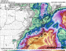
Two models you DEFINITELY want on your side!Nam and icon trying to draw me back in to this weekend system
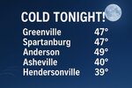
Seeing 50 for a low on Sunday morning. Hello first 40s of the fall.
Little disappointed this morning with increased temps, up to 66 here, KATL is reporting 70.
OZ EPS Latest on any October Heat for NC:
RDU, The warmest was 73 degrees on hour/panel 138. All the way out through 360 Hours. Go down Charlotte and SW back toward Atlanta/ Mississippi Valley. That's where heat will be centered. Not even sure I even saw an 80 for Charlotte, definitely few upper 70's.
RDU, The warmest was 73 degrees on hour/panel 138. All the way out through 360 Hours. Go down Charlotte and SW back toward Atlanta/ Mississippi Valley. That's where heat will be centered. Not even sure I even saw an 80 for Charlotte, definitely few upper 70's.
Noticing another Noreaster spinning up next weekend possibly Day 9-10 ish. More traditional looking, not as strong as one coming up. Pattern conducive.
59 cloudy breezy
Brent
Member
Maybe it'll cool off in November
0z euro wasn't that bad. gfs obviously too hot bc of its BL scheme. EC-AI is hot and that'll be interesting to see, i haven't really paid attention to it enough to know if it runs warm in the long range
As long as the pattern continues to predominantly force a central US ridge, we'll probably stay out of sustained big heat here, as we'll see NE troughs and wedging from time to time. We'll stay largely dry, though. Maybe we shake things up toward the end of the month.
Haven't seen this big of a split between the op and robot. The 0z euro was perfect imo regarding temps for the next 2 weeks. It looks like the models are going away from higher amplitude phase 8 mjo which may be just enough to avoid western trough and wave break ridge over the east0z euro wasn't that bad. gfs obviously too hot bc of its BL scheme. EC-AI is hot and that'll be interesting to see, i haven't really paid attention to it enough to know if it runs warm in the long range
That is the one thing I loathe about the central ridges is the perpetual dryness. At least the ridge isn't centered over Louisiana, those are the worst.As long as the pattern continues to predominantly force a central US ridge, we'll probably stay out of sustained big heat here, as we'll see NE troughs and wedging from time to time. We'll stay largely dry, though. Maybe we shake things up toward the end of the month.
The cold/wedge front came through here since sunrise bringing in the start of a surge of higher NE winds and a drop of dewpoints from ~70 to ~60. The area’s high tides for this morning will peak at ~10AM-11AM which are likely being pushed higher than yesterday due to the higher NE winds. This is likely now resulting in minor coastal flooding starting in low areas like Highway 80 on the way to Tybee, which could last til ~noon.
Charleston is now experiencing the start of moderate to possibly borderline major coastal flooding, which could last til ~noon. There have already been reports of flooding there:
0912 AM COASTAL FLOOD 1 N CHARLESTON 32.80N 79.94W
10/09/2025 CHARLESTON SC EMERGENCY MNGR
EMERGENCY MANAGER REPORTS ROAD CLOSURE DUE TO COASTAL
FLOODING AT THE INTERSECTION OF AMERICA ST AND COOPER
ST.
0921 AM COASTAL FLOOD 1 ESE CHARLESTON 32.78N 79.93W
10/09/2025 CHARLESTON SC EMERGENCY MNGR
EMERGENCY MANAGER REPORTS ROAD CLOSURE DUE TO COASTAL
FLOODING ON S MARKET ST BETWEEN CHURCH ST AND STATE ST.
—————————————
Late tomorrow morning’s high tides are still projected to be the worst of this event.
Whatever happens with the rain this weekend, today, tomorrow, and Saturday (in western sections) will feature absolutely SPECTACULAR fall weather.
When it’s roughly step for step with the GFS temps in the LR I am inclined to think it’s a bit excitable for warmth, but AI stuff has been pretty good synopticallyHaven't seen this big of a split between the op and robot. The 0z euro was perfect imo regarding temps for the next 2 weeks. It looks like the models are going away from higher amplitude phase 8 mjo which may be just enough to avoid western trough and wave break ridge over the east
That's what you call "The Dew Drop Inn"What we wait for every summer heat wave. October Cold Fronts. View attachment 175426
Edit: A little good news is that Ft. Pulaski cane in slightly lower than predicted with it at 9.84’ vs 10.0-10.1’ prediction although tomorrow morning’s is still predicted to be the highest:
PRELIMINARY LOCAL STORM REPORTS
NATIONAL WEATHER SERVICE CHARLESTON SC
THU OCT 09 2025
.TIME... ...EVENT... ...CITY LOCATION... ...LAT.LON
.DATE... ....MAG.... ..COUNTY LOCATION..ST.. ...SOURCE.
..REMARKS..
0930 AM COASTAL FLOOD 2 ENE SULLIVANS ISLAND 32.77N 79.81W
10/09/2025 CHARLESTON SC BROADCAST MEDIA
REPORT FROM SOCIAL MEDIA. VIDEO SHOWING SIGNIFICANT
BEACH EROSION FROM COASTAL FLOODING AS ADDITIONAL WAVES
WASH ASHORE AT THOMSON PARK IN THE BREACH INLET.
0957 AM COASTAL FLOOD 1 S TYBEE ISLAND 31.99N 80.85W
10/09/2025 CHATHAM GA LOCAL OFFICIAL
CITY OF TYBEE ISLAND REPORTS THEY HAD TO CLOSE THE 19TH
STREET BEACH CROSSOVER DUE TO EROSION AND SCARPING FROM
COASTAL FLOODING, MAKING IT UNSAFE FOR PUBLIC ACCESS.
1012 AM COASTAL FLOOD 1 E CHARLESTON 32.78N 79.93W
10/09/2025 CHARLESTON SC OTHER FEDERAL
A MAXIMUM TIDE LEVEL OF 7.91 FT MLLW (2.14 FT MHHW) WAS
OBSERVED AT THE CHARLESTON HARBOR TIDE GAGE. MODERATE
COASTAL FLOODING IMPACTS ARE TYPICALLY OBSERVED ALONG
COASTAL CHARLESTON AND COLLETON COUNTIES WHEN TIDE
LEVELS REACH 7.5 FT MLLW (1.73 FT MHHW) IN THE
CHARLESTON HARBOR.
1036 AM COASTAL FLOOD 4 NW TYBEE ISLAND 32.03N 80.93W
10/09/2025 CHATHAM GA OTHER FEDERAL
A MAXIMUM TIDE LEVEL OF 9.84 FT MLLW (2.33 FT MHHW) WAS
OBSERVED AT THE FORT PULASKI TIDE GAGE. MINOR COASTAL
FLOODING IMPACTS ARE TYPICALLY OBSERVED ALONG SOUTHERN
COASTAL SOUTH CAROLINA AND MUCH OF THE SOUTHEASTERN
COASTAL GEORGIA COMMUNITIES WHEN TIDE LEVELS REACH 9.5
FT MLLW (2.0 FT MHHW) AT FORT PULASKI.
——————————-
Edit:
PRELIMINARY LOCAL STORM REPORT
NATIONAL WEATHER SERVICE JACKSONVILLE FL
854 AM EDT FRI OCT 10 2025
.TIME... ...EVENT... ...CITY LOCATION... ...LAT.LON
.DATE... ....MAG.... ..COUNTY LOCATION..ST.. ...SOURCE.
..REMARKS..
1100 AM COASTAL FLOOD 3 SSW SAINT SIMONS 31.13N 81.40W
10/09/2025 AMZ450 GA MESONET
THE TIDE GAUGE AT ATLANTIC COAST AT ST.
SIMONS ISLAND AT VILLAGE PIER MEASURED 2.51
FT MHHW AT HIGH TIDE AT 11 AM. MODERATE
FLOOD STAGE BEGINS AT 2.5 FT MHHW.
Last edited:
NoSnowATL
Member
AprilMaybe it'll cool off in November
12Z Euro pretty much more of the same through the end of the run. Active pattern if yoyre in the right places. We'll continue to benefit from wedging. Yay
Brent
Member
GeorgiaGirl
Member
Today was pretty great temp wise...it's too bad it won't be holding although it does look as if we avoid anything that's worse than average to slightly above average temp wise in the eastern parts of the SE, me thinks.
Iceagewhereartthou
Member
Liking the current weather very much. NOT liking the 80s that keep showing up every few days on the outlook; it's time for those to disappear and let the cooler pattern take over for good!
Nice! My point&click forecast low is 48 with 8-10mph wind. Hoping wind verifies too low so I can get closer to mid 40's.Here we goView attachment 175436
Man there's been some super nice NW Pac Ridging been popping up on the CFS past few runs as we roll into November. This time period is still beyond the ensembles. We will get a Longwave pattern shuffle around the time we flip the monthly calendar. Usually digs in and settles by Turkey day. Fingers crossed.
48
I got down to 47.5degF here in Summerfield, NC, just north of GSO
GeorgiaGirl
Member
Still in the low 60s outside.
I honestly think this is my first time this year where I think this is a little too much.
I honestly think this is my first time this year where I think this is a little too much.
BHS1975
Member
Meh dews not that low so makes it feel warmer.Still in the low 60s outside.
I honestly think this is my first time this year where I think this is a little too much.
This is the worst coastal flooding event not associated with a TC (aka king tide) I’ve ever personally witnessed. I may post pics later.
It reached 10.35’ at Ft. Pulaski at 11:36AM very near the 10.4’ that had been forecasted the last couple of few days:
PRELIMINARY LOCAL STORM REPORT
NATIONAL WEATHER SERVICE CHARLESTON SC
1248 PM EDT FRI OCT 10 2025
.TIME... ...EVENT... ...CITY LOCATION... ...LAT.LON
.DATE... ....MAG.... ..COUNTY LOCATION..ST.. ...SOURCE.
..REMARKS..
1124 AM COASTAL FLOOD 1 E CHARLESTON 32.78N 79.93W
10/10/2025 CHARLESTON SC OTHER FEDERAL
A MAXIMUM TIDE LEVEL OF 8.46 FT MLLW (2.70 FT MHHW) WAS
OBSERVED AT THE CHARLESTON HARBOR TIDE GAGE. MAJOR
COASTAL FLOODING TYPICALLY BEGINS ALONG THE COASTS OF
CHARLESTON AND COLLETON COUNTIES WHEN TIDE LEVELS REACH
8.0 FT MLLW (2.24 FT MHHW) IN THE CHARLESTON HARBOR.
1136 AM COASTAL FLOOD 4 NW TYBEE ISLAND 32.03N 80.93W
10/10/2025 CHATHAM GA OTHER FEDERAL
A MAXIMUM TIDE LEVEL OF 10.35 FT MLLW (2.85 FT MHHW)
WAS OBSERVED AT THE FORT PULASKI TIDE GAGE LOCATED NEAR
THE SAVANNAH RIVER ENTRANCE. MODERATE COASTAL FLOODING
TYPICALLY BEGINS ALONG MUCH OF THE GEORGIA AND FAR
SOUTHERN SOUTH CAROLINA COASTS WHEN TIDE LEVELS REACH
10.0 FT MLLW (2.5 FT MHHW) AT FORT PULASKI.
1) US Highway 80 to Tybee, which was raised 8” ~2019, still had to close a little over an hour ago (even after the Ft. Pulaski tide peaked):
PRELIMINARY LOCAL STORM REPORT
NATIONAL WEATHER SERVICE CHARLESTON SC
1238 PM EDT FRI OCT 10 2025
.TIME... ...EVENT... ...CITY LOCATION... ...LAT.LON
.DATE... ....MAG.... ..COUNTY LOCATION..ST.. ...SOURCE.
..REMARKS..
1235 PM COASTAL FLOOD 4 ENE WILMINGTON ISLAND 32.02N 80.92W
10/10/2025 CHATHAM GA EMERGENCY MNGR
HIGHWAY 80 HAS BEEN CLOSED FROM THE BULL RIVER BRIDGE
TO THE LAZARETTO CREEK BRIDGE.
————————
2) I may later post pic(s) related to this next flooded but passable road ( I don’t live near there but was visiting that area):
PRELIMINARY LOCAL STORM REPORT
NATIONAL WEATHER SERVICE CHARLESTON SC
1228 PM EDT FRI OCT 10 2025
.TIME... ...EVENT... ...CITY LOCATION... ...LAT.LON
.DATE... ....MAG.... ..COUNTY LOCATION..ST.. ...SOURCE.
..REMARKS..
1225 PM COASTAL FLOOD 2 SSE VERNONBURG 31.94N 81.10W
10/10/2025 CHATHAM GA EMERGENCY MNGR
SHIPYARD ROAD TO BURNSIDE ISLAND IS FLOODED, BUT
PASSABLE.
PRELIMINARY LOCAL STORM REPORT
NATIONAL WEATHER SERVICE CHARLESTON SC
1238 PM EDT FRI OCT 10 2025
.TIME... ...EVENT... ...CITY LOCATION... ...LAT.LON
.DATE... ....MAG.... ..COUNTY LOCATION..ST.. ...SOURCE.
..REMARKS..
1235 PM COASTAL FLOOD 4 ENE WILMINGTON ISLAND 32.02N 80.92W
10/10/2025 CHATHAM GA EMERGENCY MNGR
HIGHWAY 80 HAS BEEN CLOSED FROM THE BULL RIVER BRIDGE
TO THE LAZARETTO CREEK BRIDGE.
————————
2) I may later post pic(s) related to this next flooded but passable road ( I don’t live near there but was visiting that area):
PRELIMINARY LOCAL STORM REPORT
NATIONAL WEATHER SERVICE CHARLESTON SC
1228 PM EDT FRI OCT 10 2025
.TIME... ...EVENT... ...CITY LOCATION... ...LAT.LON
.DATE... ....MAG.... ..COUNTY LOCATION..ST.. ...SOURCE.
..REMARKS..
1225 PM COASTAL FLOOD 2 SSE VERNONBURG 31.94N 81.10W
10/10/2025 CHATHAM GA EMERGENCY MNGR
SHIPYARD ROAD TO BURNSIDE ISLAND IS FLOODED, BUT
PASSABLE.
PRELIMINARY LOCAL STORM REPORT
NATIONAL WEATHER SERVICE JACKSONVILLE FL
152 PM EDT FRI OCT 10 2025
.TIME... ...EVENT... ...CITY LOCATION... ...LAT.LON
.DATE... ....MAG.... ..COUNTY LOCATION..ST.. ...SOURCE.
..REMARKS..
1215 PM COASTAL FLOOD 3 SSW SAINT SIMONS 31.13N 81.40W
10/10/2025 AMZ450 GA PUBLIC
ATLANTIC COAST AT ST. SIMONS ISLAND AT
VILLAGE PIER TIDE GAUGE MEASURED 2.78 FT
MHHW DURING HIGH TIDE AT 1215 PM. MODERATE
FLOOD STAGE BEGINS AT 2.5 FT.
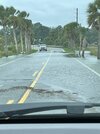
Here are 2 pics from today’s midday king tide (no rain) from earlier today that I saw. It’s since receded. The king tide was caused by a combo of
-highest astronomical tides so far in 2025, which are mainly a result of full moon/perigee
- persistent moderate (not strong) NE winds) much of this week
1. On Burnside Is. I had stopped when I saw this to take the pic. It was passable though I went real slow! When I had arrived on the island an hour earlier, the ditches were full of water but it hadn’t flooded yet.
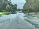
2. Causeway leaving the island from king tide (while I had stopped): again passable though I drove very slowly! There wasn’t any water on this road an hour earlier when I was arriving there though it was pretty closeby on the sides of the road.
-highest astronomical tides so far in 2025, which are mainly a result of full moon/perigee
- persistent moderate (not strong) NE winds) much of this week
1. On Burnside Is. I had stopped when I saw this to take the pic. It was passable though I went real slow! When I had arrived on the island an hour earlier, the ditches were full of water but it hadn’t flooded yet.

2. Causeway leaving the island from king tide (while I had stopped): again passable though I drove very slowly! There wasn’t any water on this road an hour earlier when I was arriving there though it was pretty closeby on the sides of the road.

Last edited:
NoSnowATL
Member
Turn around don’t drownHere are 2 pics from today’s midday king tide (no rain) from earlier today that I saw. It’s since receded. The king tide was caused by a combo of
-highest astronomical tides so far in 2025, which are mainly a result of full moon/perigee
- persistent moderate (not strong) NE winds) much of this week
1. On Burnside Is. I had stopped when I saw this to take the pic. It was passable though I went real slow!
View attachment 175448
2. Causeway leaving the island from king tide (while I had stopped): again passable though I drove very slowly!
View attachment 175449
what a bleh 12z EPS. warmtober!
edit: almost forgot! its 66 and partly cloudy with a nice NE breeze today
edit: almost forgot! its 66 and partly cloudy with a nice NE breeze today

