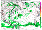
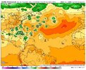
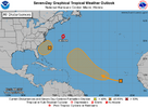
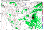
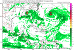
I totally understand and know the likelihood of one scenario off of one model run being far from the final result. I also understand anything at this point is moot as nothing has formed and the “pattern is not set in stone. No wishing or wanting here!i find long range fantasy hurricanes both:
1. even less likely and
2. more irritating
than fantasy snowstorms
florence was progged as a cat4/cat5 in wrightsville 3 days before landfall. i still have the screenshots on my phone. they were intense. florence was obviously still a menace but plenty of models suggested wrightsville beach would emerge from the storm a bald slab of sand and nothing else
euro ens are a fine north star to pay attention to and keep tabs on real threats if you don't want to get bogged down with doom-projecting hurricane products
-
Hello, please take a minute to check out our awesome content, contributed by the wonderful members of our community. We hope you'll add your own thoughts and opinions by making a free account!
You are using an out of date browser. It may not display this or other websites correctly.
You should upgrade or use an alternative browser.
You should upgrade or use an alternative browser.
Tropical 2025 Tropical Thread
- Thread starter SD
- Start date
Brent
Member
I totally understand and know the likelihood of one scenario off of one model run being far from the final result. I also understand anything at this point is moot as nothing has formed and the “pattern is not set in stone. No wishing or wanting here!
Right normally I wouldn't even post the 300 hour GFS but the complaints have gotten so bad in here when it's August 4th and there's actually things on the models shrugs
It'd be like giving up on winter on December 15th basically. We've passed what maybe 10 percent of the season? Maybe?
It was the same last year, then it became more active!Right normally I wouldn't even post the 300 hour GFS but the complaints have gotten so bad in here when it's August 4th and there's actually things on the models shrugs
It'd be like giving up on winter on December 15th basically. We've passed what maybe 10 percent of the season? Maybe?
Brent
Member
It was the same last year, then it became more active!
And pretty much every year.... I mean I don't know why people act like this. The seasons have been backloaded lately
BrickTamland
Member
Matthew East isn't having any of the foolishness.
My blood pressure is already rising to an (more) unhealthy level seeing the wild, careless, and nearly-impossible-to-be-accurate posts of 10-day runs of a specific model showing a hurricane making a US landfall. Stop it. Discuss the pattern growing more favorable for development, highlight some areas to watch.... stop showing Cat 4's hitting specific areas on a 10-day model run.
My blood pressure is already rising to an (more) unhealthy level seeing the wild, careless, and nearly-impossible-to-be-accurate posts of 10-day runs of a specific model showing a hurricane making a US landfall. Stop it. Discuss the pattern growing more favorable for development, highlight some areas to watch.... stop showing Cat 4's hitting specific areas on a 10-day model run.
Shaggy
Member
I like to consider it the 3 Cs
Consistency
Consensus
Confidence
Can't have confidence until we have the 1st two
Consistency
Consensus
Confidence
Can't have confidence until we have the 1st two
Shaggy
Member
yeah not meaning to sound negative nor patronizing but, and you could hear it in matthew east's post above, there's something uniquely grating about long range fantasy hurricanes that i don't feel with snowstorms and that's why you see mets stomp out any enthusiasm asapI totally understand and know the likelihood of one scenario off of one model run being far from the final result. I also understand anything at this point is moot as nothing has formed and the “pattern is not set in stone. No wishing or wanting here!
The concern I have that there may actually be something threatening somewhere in the Conus (Gulf or Atlantic coasts) (hopefully not!) as we approach midmonth is that the model consensus is suggesting there may be an extended period of the MJO being in or near phase 2 around then.
Why is a long period in phase 2 a concern? US MH hits during phase 2 (**either inside or outside the circle**) during July-Sep since 1975: Ida (2021), Harvey (2017), Irma (2017), Ivan (2004), Bret (1999), Emily (1993), Hugo (1989), Frederic (1979), Eloise (1975)….that’s 9 of 23 (39%) Jul-Sep Conus MH hits during 1975-2024 just during phase 2, alone! The 39% is more than double the ~17% of days in phase 2, meaning a significant/non-random signal for increased danger.
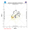
Latest MJO forecasts:
GEFS suggests long period in phase 2 inside circle
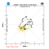
EPS similar
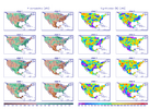
Avg precip for phases July-Sep *including inside circle*: phase 2 wettest in SE
Why is a long period in phase 2 a concern? US MH hits during phase 2 (**either inside or outside the circle**) during July-Sep since 1975: Ida (2021), Harvey (2017), Irma (2017), Ivan (2004), Bret (1999), Emily (1993), Hugo (1989), Frederic (1979), Eloise (1975)….that’s 9 of 23 (39%) Jul-Sep Conus MH hits during 1975-2024 just during phase 2, alone! The 39% is more than double the ~17% of days in phase 2, meaning a significant/non-random signal for increased danger.
Latest MJO forecasts:
GEFS suggests long period in phase 2 inside circle

EPS similar

Avg precip for phases July-Sep *including inside circle*: phase 2 wettest in SE

NWMSGuy
Member
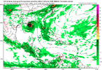
Noise at this juncture but the 12Z GFS has a Hurricane headed for the LA coast at hour 330. Close to 20 years since Katrina would be a nightmare scenario if it happened.
lexxnchloe
Member
Its doesnt even get going till much later now and its flying. This is a sign the GFS is backing off development. Also, if things are really getting favorable there would be something else coming behind it and there is nothing. Worth watching for the GOM thoughNoise at this juncture but the 12Z GFS has a Hurricane headed for the LA coast at hour 330. Close to 20 years since Katrina would be a nightmare scenario if it happened.
lexxnchloe
Member
According the the Euro/AI there is another one coming behind it. GFS ensembles are hinting at that as well.Its doesnt even get going till much later now and its flying. This is a sign the GFS is backing off development. Also, if things are really getting favorable there would be something else coming behind it and there is nothing. Worth watching for the GOM though
View attachment 173887
lexxnchloe
Member
AI just has this 1 960 low posted above with nothing behind itAccording the the Euro/AI there is another one coming behind it. GFS ensembles are hinting at that as well.
Right but that storm showing on the AI is the 2nd storm behind the one showing up on the GFS. The storm showing up on the GFS is the one that has been showing a recurve on Euro/AI models. We’ll see how it plays out.AI just has this 1 960 low posted above with nothing behind it
lexxnchloe
Member
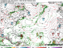
Euro remains consistent. Once again the big 3 all have a hurricane with no recurvers.Right but that storm showing on the AI is the 2nd storm behind the one showing up on the GFS. The storm showing up on the GFS is the one that has been showing a recurve on Euro/AI models. We’ll see how it plays out.
lexxnchloe
Member
Brent
Member
Yup the hurricanes are coming sooner or later. Everyone just relax 
NoSnowATL
Member
Cat 5 train coming. Gotcha.Yup the hurricanes are coming sooner or later. Everyone just relax
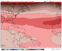
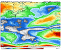
The pattern late in the period is a little concerning. Broad ridging across the Atlantic with shear decreasing. There will be an escape route or two that pops up, as the ENS will smooth things out way out in time, but the EPS does show a recurve in the MDR and then brings another wave across that takes the low road. I have a feeling that we may be talking about a significant threat that shows itself in the 12-18 day time frame or so. There's a lot of warm water out there, and shear looks to become more favorable.


lexxnchloe
Member
Brent
Member
lexxnchloe
Member
GFS recurves a very weak system 1 now east of bermuda. Lets see if it does anything with num 2So dead out there.. View attachment 173906
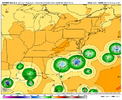
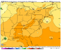
The 0Z EPS is far less active with the E MDR AEW than it was on Friday, when it had developed 50% of the members and with a good portion of these threatening the Conus with a hurricane within 8/14-16. Now it has very few members developing and has delayed the main threat to the Conus til the followup AEW.
Fri Aug 1st 12Z EPS for 0Z on 8/15:
Latest run (8/4 0Z) for 0Z on 8/15: much quieter
Fri Aug 1st 12Z EPS for 0Z on 8/15:

Latest run (8/4 0Z) for 0Z on 8/15: much quieter

lexxnchloe
Member
I doubt anything of importance will develop now. It was clear yesterday the models were seeing thingd that werent thereThe 0Z EPS is far less active with the E MDR AEW than it was on Friday, when it had developed 50% of the members and with a good portion of these threatening the Conus with a hurricane within 8/14-16. Now it has very few members developing and has delayed the main threat to the Conus til the followup AEW.
Fri Aug 1st 12Z EPS for 0Z on 8/15:
View attachment 173908
Latest run (8/4 0Z) for 0Z on 8/15: much quieter
View attachment 173909
lexxnchloe
Member
The 0Z EPS is far less active with the E MDR AEW than it was on Friday, when it had developed 50% of the members and with a good portion of these threatening the Conus with a hurricane within 8/14-16. Now it has very few members developing and has delayed the main threat to the Conus til the followup AEW.
Fri Aug 1st 12Z EPS for 0Z on 8/15:
View attachment 173908
Latest run (8/4 0Z) for 0Z on 8/15: much quieter
View attachment 173909
Last edited:
Brent
Member
lexxnchloe
Member
Im still not convinced anything will do much since the GFS and Euro are developing totally different waves
lexxnchloe
Member
Brent
Member
The fact the models keep hinting at something big is interesting to say the least. There's a cat 5 member on the EPS in the Gulf 
Like I'm not saying something major will happen but I definitely expect more activity than we've seen. In theory it should be a gradual build up and not all at once but who knows
Like I'm not saying something major will happen but I definitely expect more activity than we've seen. In theory it should be a gradual build up and not all at once but who knows
I would say give it time. Maybe nothing/ maybe something but having such strong feelings run to run is pointless! Not too many times that I can recall the models agreeing totally at this time range. I’m just going off of what you post, but you put 30 day individual models on here with hope but are skeptical with the same ones under 15. Not trying to be disrespectful at all!Im still not convinced anything will do much since the GFS and Euro are developing totally different waves
lexxnchloe
Member
The models arent agreeing. They are developing 2 totally different waves.I would say give it time. Maybe nothing/ maybe something but having such strong feelings run to run is pointless! Not too many times that I can recall the models agreeing totally at this time range. I’m just going off of what you post, but you put 30 day individual models on here with hope but are skeptical with the same ones under 15. Not trying to be disrespectful at all!
Rarely do they! If they did we would have a better idea days out!The models arent agreeing. They are developing 2 totally different waves.
For those wanting a relatively quiet season (that includes me), the new Euro seasonal NATL forecast is not what you want to see. It has substantially increased from the near normal of last month’s forecast, which had ~125 ACE, to today’s ~155. This is estimated by taking its 130% of normal for Sept+ and adding the 1.5 prior to Aug and its latest Weeklies forecast for Aug, which is now at ~40, well AN.
The implied total seasonal # of NS has risen from 15 to ~17-18. The # of H has risen from 6 to ~7.5.
The concentration of tracks at/near the Conus has risen from very slightly BN to AN.
The implied total seasonal # of NS has risen from 15 to ~17-18. The # of H has risen from 6 to ~7.5.
The concentration of tracks at/near the Conus has risen from very slightly BN to AN.
lexxnchloe
Member
Regarding the MDR orange:
1. The 12Z GFS has this hit near Cape Canaveral on 8/16 as a ~cat 1 H, which is a little before what Lexx’s map above is showing.
2. The 12Z Euro like recent runs and has this as no more than a weak sfc low. It then recurves the weak disturbance safely well out in the ocean. So, it is totally disagreeing with the GFS’ FL hit.

