Iceagewhereartthou
Member
Absolutely amazing temps tday!
An incredible 64 here with my elevated station showing 62 thanks to the heavy rain. 1.81 so far today. It's almost unreal to step outside and feel it after the length of the misery we have had to endure.It is 67 degrees at 1pm with 1.29" of rain thus far today. WINNING!


Nice round of light rain in Denver for the last hour.Is this a bit confusing? Anyone’s else in the Piedmont seeing rain but zero from the and Upstate / Charlotte point/ click?
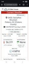
View attachment 173853
Sent from my iPhone using Tapatalk

Ended up playing one inning before they postponed the game until today. Got out just before the rush of people but still didn't get back to Boone until 1am. And man, US421 between Bristol and Mountain City is a crazy road. Especially with the rain and fog. They call it "The Snake" for good reason. So my oldest son went back today and saw the Braves win the game 4 to 2.I almost got tickets for this one. Let me know how it goes! Looks like a big time
The winter after Alberto sucked if I recall. The winter of 94-95.64.9 here for a low so far. And with tropical systems in play maybe it stays unusually cool for a while? Like after td Alberto. Super hot summer before, nice and cool, relatively speaking, on into fall, after.
Correct. That winter was one of the worst we have had in the southeast. Here in upstate SC only the winter of 1991-92 was worse.The winter after Alberto sucked if I recall. The winter of 94-95.
Sounds like a good day. Cant beT those views from frying panWent up to 5000’+ on the parkway today and found some low 50s at Fryingpan Tower. <0.1mi visibility for much of the parkway.
Back home, temps busted low! Thanks CAD. Topped out at 70
Oh it was entirely socked in. Not an ounce of a view, <0.1mi visSounds like a good day. Cant beT those views from frying pan
Don't recall the winter, except we didn't get another blizzard, lol. But I remember the night and day summer.The winter after Alberto sucked if I recall. The winter of 94-95.
Feels like it’s payback for the relentless heat we saw in July. Need 2-3 weeks of thisGSO is sitting at -7.1 BN so far for the young month of August. Not forecasted to even sniff 80 again for a high temp until the weekend. I've seen cool shots/fronts in August before, but not one last 7+ days, like this one. Hopefully we don't have to pay-back for this come September.

Yep. Drought buster otw for the lee side screw zone. It was tough sledding in July. Starting August off on the right trackPretty concerning look from latest HREF today. Here’s 24 hours from 8pm tonight to 8pm tomorrow View attachment 173884

I hope that is overdone; no one needs flashflooding.Pretty concerning look from latest HREF today. Here’s 24 hours from 8pm tonight to 8pm tomorrow View attachment 173884

There's still pretty decent disagreement/uncertainty on a heavier band overnight and into tomorrow AM somewhere likely in the upstate or SWNC. Southerly-ish flow upslope should get some pretty good amounts for the SC escarpment. WPC discussion is greatI hope that is overdone; no one needs flashflooding.