• Hello, please take a minute to check out our awesome content, contributed by the wonderful members of our community. We hope you'll add your own thoughts and opinions by making a free account!

Pattern Outside of the SE thread

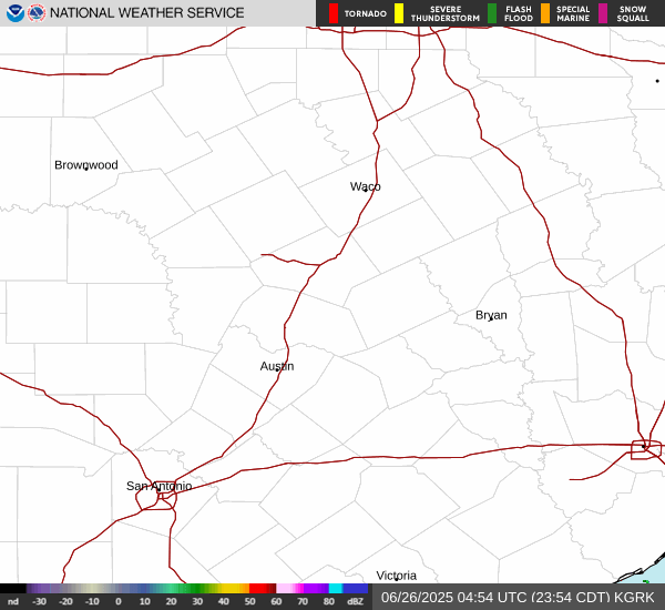
836 PM CDT MON MAY 26 2025

THE NATIONAL WEATHER SERVICE IN AUSTIN SAN ANTONIO HAS ISSUED A

* SEVERE THUNDERSTORM WARNING FOR...
WILLIAMSON COUNTY IN SOUTH CENTRAL TEXAS...
CENTRAL TRAVIS COUNTY IN SOUTH CENTRAL TEXAS...
NORTHEASTERN BASTROP COUNTY IN SOUTH CENTRAL TEXAS...
NORTHWESTERN LEE COUNTY IN SOUTH CENTRAL TEXAS...

* UNTIL 945 PM CDT.

* AT 835 PM CDT, SEVERE THUNDERSTORMS WERE LOCATED ALONG A LINE
EXTENDING FROM 7 MILES NORTH OF FLORENCE TO GEORGETOWN DAM TO NEAR
HUDSON BEND, MOVING EAST AT 40 MPH.

THESE ARE DESTRUCTIVE STORMS FOR JARRELL, GRANGER, AND BARLETT.

HAZARD...80 MPH WIND GUSTS AND PENNY SIZE HAIL.

SOURCE...RADAR INDICATED.

IMPACT...FLYING DEBRIS WILL BE DANGEROUS TO THOSE CAUGHT WITHOUT
SHELTER. MOBILE HOMES WILL BE HEAVILY DAMAGED. EXPECT
CONSIDERABLE DAMAGE TO ROOFS, WINDOWS, AND VEHICLES.
EXTENSIVE TREE DAMAGE AND POWER OUTAGES ARE LIKELY.

* LOCATIONS IMPACTED INCLUDE...
AUSTIN, ROUND ROCK, CEDAR PARK, GEORGETOWN, PFLUGERVILLE, TAYLOR,
ELGIN, GRANGER, LEXINGTON, SERENADA, ANDERSON MILL, WINDEMERE,
LEANDER, HUTTO, LAKEWAY, MANOR, LAGO VISTA, HUDSON BEND, BARTLETT,
AND THE HILLS.

PRECAUTIONARY/PREPAREDNESS ACTIONS...

A TORNADO WATCH REMAINS IN EFFECT UNTIL 1000 PM CDT FOR SOUTH CENTRAL
TEXAS.

THIS IS AN EXTREMELY DANGEROUS SITUATION WITH TORNADO LIKE WIND
SPEEDS EXPECTED.
MOBILE HOMES AND HIGH PROFILE VEHICLES ARE
ESPECIALLY SUSCEPTIBLE TO WINDS OF THIS MAGNITUDE AND MAY BE
OVERTURNED. FOR YOUR PROTECTION MOVE TO AN INTERIOR ROOM ON THE
LOWEST FLOOR OF A BUILDING. THESE STORMS HAVE THE POTENTIAL TO CAUSE
SERIOUS INJURY AND SIGNIFICANT PROPERTY DAMAGE.

LARGE HAIL, DAMAGING WIND, AND CONTINUOUS CLOUD TO GROUND LIGHTNING
ARE OCCURRING WITH THESE STORMS. MOVE INDOORS IMMEDIATELY. LIGHTNING
IS ONE OF NATURE'S LEADING KILLERS. REMEMBER, IF YOU CAN HEAR
THUNDER, YOU ARE CLOSE ENOUGH TO BE STRUCK BY LIGHTNING.

TORRENTIAL RAINFALL IS OCCURRING WITH THESE STORMS, AND MAY LEAD TO
FLASH FLOODING. DO NOT DRIVE YOUR VEHICLE THROUGH FLOODED ROADWAYS.

A TORNADO WATCH REMAINS IN EFFECT UNTIL 1000 PM CDT FOR SOUTH CENTRAL
TEXAS.
 
849 PM CDT MON MAY 26 2025

THE NATIONAL WEATHER SERVICE IN AUSTIN SAN ANTONIO HAS ISSUED A

* TORNADO WARNING FOR...
NORTHEASTERN WILLIAMSON COUNTY IN SOUTH CENTRAL TEXAS...

* UNTIL 900 PM CDT.

* AT 849 PM CDT, A SEVERE THUNDERSTORM CAPABLE OF PRODUCING A TORNADO
WAS LOCATED NEAR BARTLETT, OR 8 MILES NORTHWEST OF GRANGER, MOVING
EAST AT 35 MPH.

HAZARD...TORNADO.

SOURCE...RADAR INDICATED ROTATION.

IMPACT...FLYING DEBRIS WILL BE DANGEROUS TO THOSE CAUGHT WITHOUT
SHELTER. MOBILE HOMES WILL BE DAMAGED OR DESTROYED.
DAMAGE TO ROOFS, WINDOWS, AND VEHICLES WILL OCCUR. TREE
DAMAGE IS LIKELY.

* LOCATIONS IMPACTED INCLUDE...
BARTLETT AND SCHWERTNER.
 
851 PM CDT MON MAY 26 2025

THE NATIONAL WEATHER SERVICE IN FORT WORTH HAS ISSUED A

* TORNADO WARNING FOR...
WEST CENTRAL MILAM COUNTY IN CENTRAL TEXAS...
SOUTHEASTERN BELL COUNTY IN CENTRAL TEXAS...

* UNTIL 930 PM CDT.

* AT 851 PM CDT, A SEVERE THUNDERSTORM CAPABLE OF PRODUCING A TORNADO
WAS LOCATED OVER BARTLETT, OR NEAR GRANGER, MOVING EAST AT 45 MPH.

HAZARD...TORNADO AND QUARTER SIZE HAIL.

SOURCE...RADAR INDICATED ROTATION.

IMPACT...FLYING DEBRIS WILL BE DANGEROUS TO THOSE CAUGHT WITHOUT
SHELTER. MOBILE HOMES WILL BE DAMAGED OR DESTROYED.
DAMAGE TO ROOFS, WINDOWS, AND VEHICLES WILL OCCUR. TREE
DAMAGE IS LIKELY.

* THIS DANGEROUS STORM WILL BE NEAR...
BARTLETT AND HOLLAND AROUND 855 PM CDT.
BUCKHOLTS AROUND 915 PM CDT.
CAMERON AROUND 925 PM CDT.

OTHER LOCATIONS IMPACTED BY THIS TORNADIC THUNDERSTORM INCLUDE SHARP,
VAL VERDE, PETTIBONE, AND DAVILLA.
 
ww0334_warnings_resize.gif
 
Radar map a few posts up.

FLASH FLOOD WARNING
NATIONAL WEATHER SERVICE AUSTIN/SAN ANTONIO TX
1138 AM CDT FRI JUL 4 2025

...FLASH FLOOD EMERGENCY FOR THE GUADALUPE RIVER FROM HUNT THROUGH
KERRVILE AND CENTER POINT...

THE NATIONAL WEATHER SERVICE IN AUSTIN/SAN ANTONIO HAS EXTENDED THE

* FLASH FLOOD WARNING FOR...
EAST CENTRAL KERR COUNTY IN SOUTH CENTRAL TEXAS...

* UNTIL 300 PM CDT.

* AT 1138 AM CDT, AUTOMATED RAIN GAUGES INDICATE A LARGE AND DEADLY
FLOOD WAVE IS MOVING DOWN THE GUADALUPE RIVER
. FLASH FLOODING IS
ALREADY OCCURRING.

THIS IS A FLASH FLOOD EMERGENCY FOR THE GUADALUPE RIVER FROM HUNT
THROUGH KERRVILE AND CENTER POINT. THIS IS A PARTICULARLY
DANGEROUS SITUATION. SEEK HIGHER GROUND NOW!

HAZARD...LIFE THREATENING FLASH FLOODING. THUNDERSTORMS
PRODUCING FLASH FLOODING.

SOURCE...RADAR AND AUTOMATED GAUGES.

IMPACT...THIS IS A PARTICULARLY DANGEROUS SITUATION. RESIDENTS
IN CAMPERS SHOULD SEEK HIGHER GROUND NOW! LIFE
THREATENING FLASH FLOODING ALONG THE GUADALUPE RIVER
IS EXPECTED TO CONTINUE.

* SOME LOCATIONS THAT WILL EXPERIENCE FLASH FLOODING INCLUDE...
KERRVILLE, INGRAM, HUNT, KERRVILLE-SCHREINER PARK, WALTONIA AND
CENTER POINT.

PRECAUTIONARY/PREPAREDNESS ACTIONS...

MOVE TO HIGHER GROUND NOW! THIS IS AN EXTREMELY DANGEROUS AND
LIFE-THREATENING SITUATION.

TURN AROUND, DON'T DROWN WHEN ENCOUNTERING FLOODED ROADS. MOST FLOOD
DEATHS OCCUR IN VEHICLES.

STAY AWAY OR BE SWEPT AWAY. RIVER BANKS AND CULVERTS CAN BECOME
UNSTABLE AND UNSAFE.

FLOODING IS OCCURRING OR IS IMMINENT. IT IS IMPORTANT TO KNOW WHERE
YOU ARE RELATIVE TO STREAMS, RIVERS, OR CREEKS WHICH CAN BECOME
KILLERS IN HEAVY RAINS. CAMPERS AND HIKERS SHOULD AVOID STREAMS OR
CREEKS.

FLASH FLOOD...RADAR AND GAUGE INDICATED
FLASH FLOOD DAMAGE THREAT...CATASTROPHIC

Also for adjoining area

 
Oh fun! Coastal Maine has a slight risk for severe weather for tomorrow!

From SPC:

"New England into northern Mid Atlantic...
Based on latest model output, confidence is increasing in the
likelihood of appreciable (CAPE in excess of 1000 J/kg) pre-frontal
boundary-layer destabilization ahead of the southward advancing
front, as far north as the southern tier of New York through
portions of northern Vermont/New Hampshire into central Maine by
around 18-19Z Sunday afternoon. Forcing for ascent along/ahead of
the front, aided by the approaching upstream mid-level trough, is
expected to support the initiation of strong thunderstorm
development, in the presence of west-southwesterly deep-layer mean
flow on the order of 30 kt. Forecast soundings indicate moistening
thermodynamic profiles, including surface dew points in the mid 60s
to near 70F, but with sufficient sub-saturation to allow for
evaporative cooling, in addition to heavy precipitation loading, to
enhance downdrafts and downward momentum transfer.

Initial activity probably will be accompanied by potentially
damaging downbursts, and perhaps some hail, before perhaps
consolidating into a line with a continuing risk for strong to
severe gusts while spreading southeastward into and across coastal
areas."

Sounds like a fun day after two tornado warnings way up by Caribou earlier this week!
 
Still haven't hit 100 here yet

Might get close next week for a day or two but still looks like a front beyond that... Time is ticking becomes a lot more rare after the 2nd week of August and September doesnt even average 1 day
 
Still haven't hit 100 here yet

Might get close next week for a day or two but still looks like a front beyond that... Time is ticking becomes a lot more rare after the 2nd week of August and September doesnt even average 1 day
You would think since temps have been around average this summer in Tulsa that it would have already hit 100. It’s not like it’s been a cool summer. Tulsa was +0.2 in June and -0.1 in July. So that’s right at average.
 
You would think since temps have been around average this summer in Tulsa that it would have already hit 100. It’s not like it’s been a cool summer. Tulsa was +0.2 in June and -0.1 in July. So that’s right at average.

97 is the hottest. Not even close. I think all the rain and humidity has been keeping highs down

We also haven't had a low above 80 which is almost more unheard of to me... We've had lows near 90 in the hottest summers
 
97 is the hottest. Not even close. I think all the rain and humidity has been keeping highs down

We also haven't had a low above 80 which is almost more unheard of to me... We've had lows near 90 in the hottest summers
Given the information you just provided, are you surprised that temps are running near normal ?
 
Back
Top