-
Hello, please take a minute to check out our awesome content, contributed by the wonderful members of our community. We hope you'll add your own thoughts and opinions by making a free account!
You are using an out of date browser. It may not display this or other websites correctly.
You should upgrade or use an alternative browser.
You should upgrade or use an alternative browser.
Pattern May or May not
- Thread starter SD
- Start date

Shaggy
Member
Bad news for the firefighters as the fire went from 100% contained all the way down to zero again.
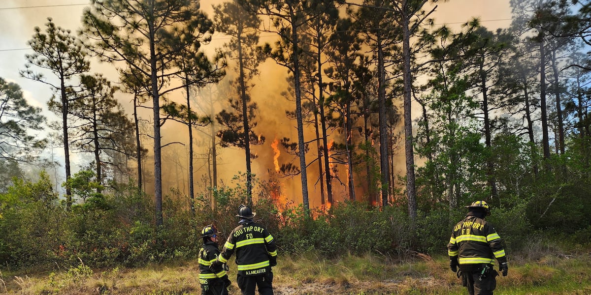
 www.wect.com
More evacuations ordered as high winds cause Boiling Spring Lakes fire to break containment lines
The NC Forest Service says the fire has grown to 450 acres.
www.wect.com
kennedybb6
Member
We are having a severe thunderstorm with hail here in Rock Hill SC
Seabrreze rolled through early today, dews 
6.5 felt in West Texas. Not your normal spot for +6 shaker
GeorgiaGirl
Member
Hopefully tomorrow evening pans out rain wise. It's just been as dry as a bone lately.
Success (and it came in the afternoon). Didn't check the rain gauge, but there was a solid bout of rain that fully covered the road.
I'm wondering some about this line. Still some time before it gets to me, but you have tornado warnings popping up.
Prob weakens though before it gets to us.
Drought buster lining up tonight. This thing is moving at a crawl
May notMay or May not rain
2.25” today on top of 1.32” yesterday.
.21 squirt gunLooks like 2”+ reports west of Elberton and they are still along and just inside the initial rain line. Training
@SD super soaker en route

Last edited:
Brent
Member
Feels like fall here... The humidity is gone! Lol
The stormy pattern is returning by Tuesday and Wednesday though
The stormy pattern is returning by Tuesday and Wednesday though
JHS
Member
Finally got it good last night after 9pm. Multiple storms including that line and then about 2 hours of rain after it.

I figured you were piling up. Everyone of those lines weakened or died as they started their rotation north just east of you, and west of me. Obviously I received some rain, about 1.5" total, but totally shafted compared to what you received.2.25” today on top of 1.32” yesterday.
Stormy May Day, as Bon Jovi would say
2 inches
2 inches
First storms of the day

The heavens have finally answered with that narrow band moving up through Horry County and into SENC. Funny that ILM was poo-pooing chances of much today due to mid level dry air. Just thankful we've finally picked up that .5"-.75" we thought was coming last night.
GeorgiaGirl
Member
For the fact we had two bouts of rain and what I heard last night as I was struggling to fall asleep...surprisingly just 0.5" I think.
But there should be a LOT more beginning in a few days.
But there should be a LOT more beginning in a few days.
JHS
Member
The Euro says no for many of us. Under .50 for much of NC and SC and north GA through day 15.For the fact we had two bouts of rain and what I heard last night as I was struggling to fall asleep...surprisingly just 0.5" I think.
But there should be a LOT more beginning in a few days.
Crisp 45.4 this morning. Everyone, enjoy your day!!
BTW- I only managed to get 1.03" in the last round of rain.
BTW- I only managed to get 1.03" in the last round of rain.
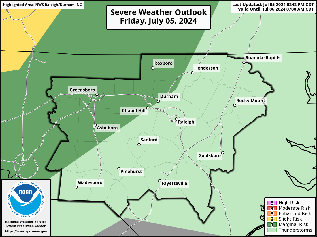
If the euro is right Friday is the first legitimate severe threat for central and eastern carolinas in a while
May or May notIf the euro is right Friday is the first legitimate severe threat for central and eastern carolinas in a while
PING PONG SIZED HAIL IN APEX!
People and animals outdoors will be injured.
Now quarter sized!
HAZARD...Quarter size hail.
SOURCE...Radar indicated. At 12:07pm, penny size hail was reported
in Research Triangle Park.
My father is testing right now in fayetteville and hearing reports that hail being reported in Durham off NC 55
SEVERE THUNDERSTORM WATCH INCOMING! TILL 9PM!

AAAnd the slight risk is now expanded!
WW0223 in effect till 9pm tonight due to high winds and hail.

Last edited:

Brent
Member
Really gonna miss this nice weather 
Loud lightning here!
Its now out!
Getting too crowded and outflowy now probably a 95 and east event now
WATCH COUNTY NOTIFICATION FOR WATCH 223NATIONAL WEATHER SERVICE RALEIGH NC125 PM EDT MON MAY 5 2025The National Weather Service has issued severe thunderstorm watch223 in effect until 9 PM EDT this evening for the following areasin north carolina this watch includes 15 countiesin central north carolinacumberland durham edgecombe franklin granville halifax harnett johnston nash sampson vance wake warren wayne wilson this includes the cities of angier, apex, buies creek, cary, clayton, clinton, creedmoor, dunn, durham, enfield, erwin, fayetteville, franklinton, goldsboro, henderson, hope mills, kittrell, knightdale, lillington, louisburg, nashville, norlina, oxford, princeville, raleigh, roanoke rapids, rocky mount, roseboro, rougemont, scotland neck, selma, smithfield, spring hope, spring lake, tarboro, wake forest, warrenton, and wilson.
.9 today solid
Drizzle Snizzle
Member
What a beautiful day. Just a few clouds and temps in the 70s with a nice breeze !
I'm surprised that Flash Flood Warnings haven't been issued for Wake County considering the heavy rain that is falling from the training thunderstorms that have been over the area for the past few hours. It's going to be interesting to see what the rain gauge measures when I
get back to the house this evening.
get back to the house this evening.