• Hello, please take a minute to check out our awesome content, contributed by the wonderful members of our community. We hope you'll add your own thoughts and opinions by making a free account!

Pattern December, Make analogs relevant again

Yeah Olhausen that's some serious cold. Looks like -5 around here. Would be coldest I've experienced in 30+ years. What is the coldest you've been since moving to TN ?
 
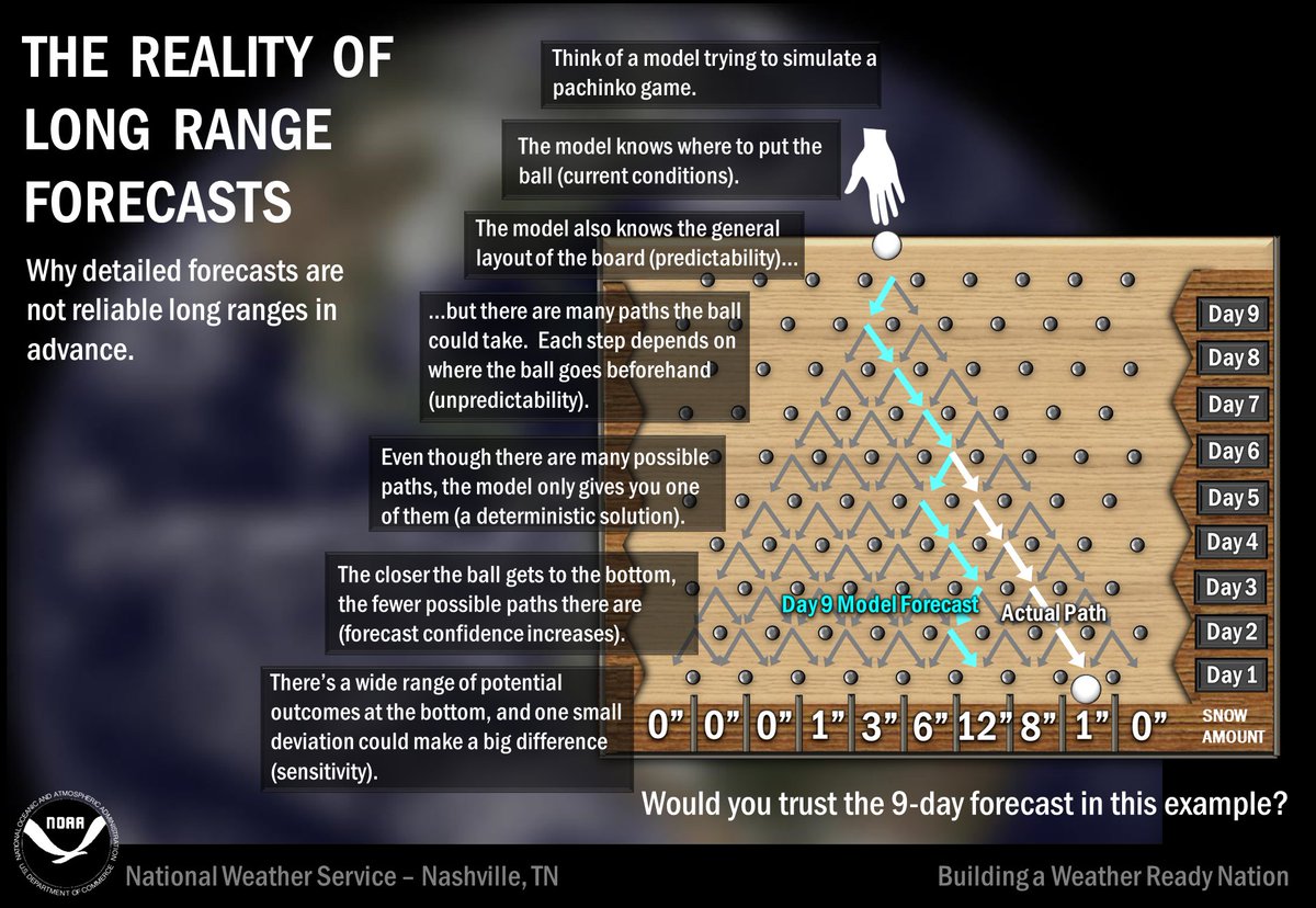
EPS continue to bring the cold days 10-15.


Sent from my iPhone using Tapatalk
Pretty soon 10-15 days will be April!
Everything was going great, and the pattern seems all " Bill Buckner" like
 
Looking interesting
hazards_d8_14_contours.png
 
I'm not being snippy at all. I was being simplistic on a term. Most people know what I meant. It's also easier to post on a mobile phone that spell checks you into the crazy house.

I posted of course in agreement to you, because you are right about the PNA being just a term for what is shown. However, it saves me a bunch of time making a quick post to say it like I did. If we take out simple ways to say something, we will need to use five or six sentences instead of using the term "warm nose".

Ah okay gotcha and yes you're right, this is just a big pet peeve of mine, and I want to eliminate any potential confusion on that front, because too many times in the blogosphere, social media, and even literature teleconnections are misrepresented for what they truly are and people interpret them as forcings in the pattern when it should be very obvious that's not the case. For example saying the PNA is forcing a trough in the SE US isn't necessarily correct because a trough in the southeastern US actually projects onto the PNA pattern and is a component of the index so you'd essentially be saying the trough in the SE US is forcing itself. That doesn't mean we all should completely eradicate saying that we need "x" teleconnection to be in such configuration, to yield "x" result in "x" location but it's important to remind new and pre-existing users what these indices truly mean and what we can superficially glean from them at first glance. A more extensive, detailed analysis is required to diagnose what actually forces the pattern to behave a certain way in the SE US...

Speaking of which, this pattern in the 11-15 day period should look very familiar. I suspect the persistence of this pattern is related to the disproportionate warming in the Indian Ocean relative to the rest of the globe that's changing the placement of the exit region of the Pacific Jet (IO forcing leads to Northeast Pacific blocking). This is working in concert w/ lower arctic sea ice and higher Eurasian snowfall extent in the fall, which means there's more potential baroclinic instability for Rossby Waves in the Pacific jet to feed on and the cold air advection and mixing of the upper ocean associated with them is stronger, which cools the sea surface along and north of the axis of the Pacific jet, leading to enhancement of the +PDO that's dominated since 2013, and this aids in reinforcing anticyclonic wave breaking near the Rockies that initially instigates these large, planetary-scale ridges that later retrograde towards Alaska, the Bering Sea, and Northeastern Eurasia and project onto the negative phase of the EPO/WPO.
WKE0XQS1Ao.png
eps_z500a_5d_nh_61.png
 
eps also has a snow that keeps creeping south
Anything still seems on the table. I havnt seen a good SE trend since the white Christmas storm of 2010! We're due
 
Anything still seems on the table. I havnt seen a good SE trend since the white Christmas storm of 2010! We're due
You haven’t seen much of a big west -NAO either pal!
 
Yeah Olhausen that's some serious cold. Looks like -5 around here. Would be coldest I've experienced in 30+ years. What is the coldest you've been since moving to TN ?

The coldest I’ve seen my low temp gauge read since I’ve lived here was -3 or -4 degrees. I’ve gone below zero 2 or 3 winters and probably 4-5 times total since 2006. As far as high temps the coldest I remember is probably 15-17 degrees above zero. I’d say every other winter on average I have a few times a season where my high only reaches the upper teens. Of course this is not exact but just based on memory.
 
Here's the US temperature composite and corresponding z500 map for -EPO/+NAO cool neutral or NINA Januarys. SE ridge ftw...
View attachment 2072
View attachment 2073

1. Hopefully, we have a near neutral NAO late this month, which the GEFS is predicting, as opposed to the +NAO you're assuming in the above analysis.

2. This is no ordinary strength -EPO being progged. The 12Z Euro has a +535 m anom being progged and the models have the EPO index, itself, approaching or even more intense than -400. A more run of the mill strong -EPO could easily have only a +250 to +300 anom. ridge or just a -300 peak daily index.

3. -EPO ridge location: Furthermore, your map's mean -EPO ridge is centered way over in SW AK. The upcoming one is being progged by the EPS to be in a more favorable for SE cold NW Can. or about 750 miles ENE.

4. Very strong -EPO duration: The 0Z GEFS is progging this -EPO to be below -350 for 6 straight days, which would tie the record going back to 1948!

*So, no ordinary strength or duration and a better than average ridge location.*

5. The MJO is being progged by the EPS to be in a favorable position for SE cold.
 
Last edited:
Let's play a game. The Nuns taught this to me back in grade school. It's point was to hone the mind to detail.
The exercise was to take a picture, study it, and find everything wrong with it. The greater number of unsuitable items you came up with, the higher the grade on the assignment. It was indeed a very brutal but enlightening elementary education.
So, if you wanna play, sharpen your pencils and jot down all that is wrong here:

ecmwf_z500_noram_198.thumb.png.c36bfe37b1ac02d60f672cbe70630300.png


:eek:
 
Could this storm actually hang around longer in Texas as 18z is showing, and allow the secondary cold blast to come through and give the SE a better chance at something?
 
Let's play a game. The Nuns taught this to me back in grade school. It's point was to hone the mind to detail.
The exercise was to take a picture, study it, and find everything wrong with it. The greater number of unsuitable items you came up with, the higher the grade on the assignment. It was indeed a very brutal but enlightening elementary education.
So, if you wanna play, sharpen your pencils and jot down all that is wrong here:

ecmwf_z500_noram_198.thumb.png.c36bfe37b1ac02d60f672cbe70630300.png


:eek:

I don't know about wrong, but regarding what i'd like to see, no aiming toward the SW US of the flow,
 
Back
Top