.gif")
.gif")
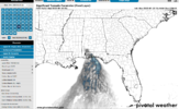
This one may be a little limited on aerial coverage but looks prime to have a number of severe reports
Rough going for southern LA/MS/AL for straight line winds?View attachment 131017
View attachment 131018
This one may be a little limited on aerial coverage but looks prime to have a number of severe reports
Probably wind but I can't help but think 1 or 2 tornadoes especially well south in the panhandleRough going for southern LA/MS/AL for straight line winds?
If we get 40-50mph gusts, power outages are gonna be more than scattered. The ground is absolutely saturated.Wind advisories out from the gulf coast to Nashville. 40 to 50 mph gusts from gradient winds possible. Mets here in Birmingham are mentioning scattered power outages could occur.
Big upgrade for the east coast Wed...the 00Z Nam3k was rather meh though...
6z 3k NAM tried to get some storms going in coastal sections and fwiw the LR HRRR had a couple UD helicity swaths down east. Also I'm guessing it's been expanded for potential wind issues if storms can get going. Low cape, high shear always has a couple of surprises


Tornado EmergencyStorm in the Houston area. Sheesh. CC maxed outView attachment 131178View attachment 131179
A mobile home park and several cluster home developments are right under that signature. That's going to be ugly.Storm in the Houston area. Sheesh. CC maxed outView attachment 131178View attachment 131179
 HRRR Radar tomorrow around 4-5pm
What was the official forecasted wind gust in your area?What happened to all of the wind they predicted?
This rain is going to do a good job at locking a decent amount of people in a wedgier air mass. I actually think this line is rocking from about my house SEI see the threat shifted SE today, not surprising, cold stable airmass across our region gonna be stubborn.
Got real windy in Houston.What happened to all of the wind they predicted?
Wind is SE here now temp up 5 degrees in the last 30 minutesThis rain is going to do a good job at locking a decent amount of people in a wedgier air mass. I actually think this line is rocking from about my house SE


regardless of severe or not its gonna boost our totals which have already been solidGreenville inbound
View attachment 131331


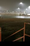
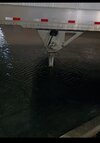
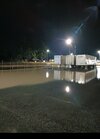
More June like than Jan..The catch pond for the two facilities here us backed up and the ditch that feeds it is now backing up towards my back set of docks

Pgv reported 1.92 in one hourYeah would not be surprised to see a new daily rainfall record at PGV