That part is gonna pack a wallop.
-
Hello, please take a minute to check out our awesome content, contributed by the wonderful members of our community. We hope you'll add your own thoughts and opinions by making a free account!
You are using an out of date browser. It may not display this or other websites correctly.
You should upgrade or use an alternative browser.
You should upgrade or use an alternative browser.
Severe 3/21-3/24 Severe Weather
- Thread starter SD
- Start date
No kidding. Qlcs tornado spin up aside I'd be very concerned about straight line wind damage if I were in the path of that this afternoon especially as it starts getting a little forward momentum. Have some 70mph pixels at 3k ft, not going to take a lot of force those downwardThat part is gonna pack a wallop.
Z
Zander98al
Guest
Spectacular shelf cloud as well ?No kidding. Qlcs tornado spin up aside I'd be very concerned about straight line wind damage if I were in the path of that this afternoon especially as it starts getting a little forward momentum. Have some 70mph pixels at 3k ft, not going to take a lot of force those downward
Z
Zander98al
Guest
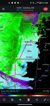
Cell northwest of soso is picking up on lighting and now picking up on rotation.
Yeah I’m just north of bham and I’m very concerned about the possibility of damaging straight line winds.No kidding. Qlcs tornado spin up aside I'd be very concerned about straight line wind damage if I were in the path of that this afternoon especially as it starts getting a little forward momentum. Have some 70mph pixels at 3k ft, not going to take a lot of force those downward
Detective WX
Member
It's windy in Atlanta and balmy at 72. Really don't like AM rush hour with squall line blowing through here...
Z
Zander98al
Guest
Bama Ravens
Member
Really wondering if this the main story of this event will be the QLCS with damaging straight line winds and embedded tornadoes rather than discrete cells being the big story.
To be honest, it always was. The discrete threat was pretty much confined to south/central MS where that area “can get away with” SW to SSW winds aloft and have a big supercell or two.Really wondering if this the main story of this event will be the QLCS with damaging straight line winds and embedded tornadoes rather than discrete cells being the big story.
Z
Zander98al
Guest
lj0109
Member
Z
Zander98al
Guest
Tornado almost on the ground probably about to get warnedThis junk that has been running next to it is finally getting pulled into that cell/meso and may clear the inflow to allow it to produce here shortly: View attachment 116080
Z
Zander98al
Guest
NBAcentel
Member
Z
Zander98al
Guest
These supercells aren't doing much which is good, lack of mid-level lapse rates?
Too much contamination.These supercells aren't doing much which is good, lack of mid-level lapse rates?
Z
Zander98al
Guest
Z
Zander98al
Guest
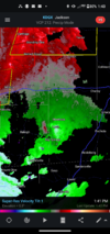
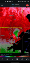
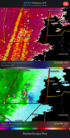
TDS with the tornado above. Continuing to rapidly strengthen
*May be contamination hard to tell right this second
*May be contamination hard to tell right this second
Z
Zander98al
Guest
Z
Zander98al
Guest
Pretty strong rotation in the tornado warned storm heading to the state line
Z
Zander98al
Guest
TDS back on the ground now
Z
Zander98al
Guest
Z
Zander98al
Guest
Z
Zander98al
Guest
Z
Zander98al
Guest
EMTime
Member
Tor warning clay County ms.
Bama Ravens
Member

Mesoscale Discussion 0311
NWS Storm Prediction Center Norman OK
0256 PM CDT Tue Mar 22 2022
Areas affected...Western Alabama
Concerning...Tornado Watch 62...
Valid 221956Z - 222200Z
The severe weather threat for Tornado Watch 62 continues.
SUMMARY...Some threat for damaging wind gusts and QLCS tornadoes
will continue into western Alabama this afternoon. The threat will
generally be greater in west-central Alabama where moisture/buoyancy
is greater.
DISCUSSION...Storms within central/eastern Mississippi have largely
remained linear this afternoon. There are some discrete cells ahead
of the the primary line. The most substantial of these discrete
storms is moving northeast through Kemper County, MS and has
recently shown a TDS on KDGX radar. The overall expectation is for
these cells to be overtaken by the line in the next 60-90 minutes.
Going forward, wind damage and QLCS tornadoes are expected to be the
primary threats as convection moves into western Alabama. The
environment ahead of the convective line has been able to warm to
near 80 F in several places. However, moisture return in Alabama has
been much less than in Mississippi. Consequently, MLCAPE values have
remained from 300-400 J/kg in northern Alabama to 500-700 in
west-central Alabama. Due to the forward speed of the line, it is
uncertain how much further destabilization can occur through the
afternoon. In any event, some potential for damaging wind gusts and
QLCS tornadoes will exist given the strong low-level winds and
low-level hodograph turning observed in region VWPs.
NBAcentel
Member
That’s what some have been saying here for a couple days, lots of signals the last few days to what we are seeing now, I even mentioned a couple days ago that this setup has shear parameters more favorable for training/flooding. not to say supercells could really get going and produce over the next couple of hours,These supercells aren't doing much which is good, lack of mid-level lapse rates?
Bama Ravens
Member
While it is still likely we will see more tornadoes and possibly a strong one somewhere, I personally don't think the moderate risk has verified today. Either in placement of the moderate risk or in intensity of the storms.
Z
Zander98al
Guest
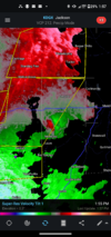
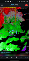
TDS near west point Ms
Z
Zander98al
Guest
I think It was decent, there's probably going to be a lot of tornado reports I'n the coming days. The amount of QCLS tornado spin ups have been insane over MS. Haven't had the classic supercell tornadoes but spin ups galore. Your biggest threat though so far today has been damaging winds and flooding it seems.While it is still likely we will see more tornadoes and possibly a strong one somewhere, I personally don't think the moderate risk has verified today. Either in placement of the moderate risk or in intensity of the storms.
Z
Zander98al
Guest
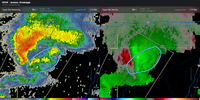
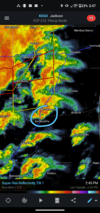
WOW. Very impressive signature at the west point one for being so close to the radar still with a TDS. May have a significant tornado there
Z
Zander98al
Guest
A faint debris ball on reflectivity as well!
Z
Zander98al
Guest
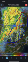
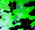
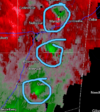
Those northern line rotations are looking nasty now. This event is far from over.
HSVweather
Member
Z
Zander98al
Guest
That's the one below the debris ball one. That one is impressive as well.
HSVweather
Member

