• Hello, please take a minute to check out our awesome content, contributed by the wonderful members of our community. We hope you'll add your own thoughts and opinions by making a free account!

Misc 2021-22 Fall/Winter Whamby Thread

Hey we saw a insane SE can vortex last March or april if I’m not mistaken it can happen ig
I'm just giving you a hard time. There's so much volatility in that time frame when you look at the spreads I figure we will get a few more weenie runs over the coming days but really it's not a super favorable look. That said when was the last time we scored big in a marginal look? Maybe we are due
 
Lmaooo if that look actually ends up panning out, I will have problems with being able to get home after Christmas.

Guess it's time for me to start looking at weather models again (just loaded up the site that I use).
 
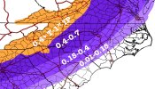
gfs_asnow_us_65.png
 
Nice graphic! If there will indeed be a winter storm, I hope to see more of your work!

That’s more like it. I want the Cat 5/ EF5 ice storm. End of the world type.
Well, it's been many of years since an ice storm on that magnitude - something just might give.
________________________________________

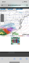
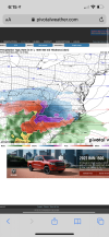
As we know, the GFS tonight finally shows a winter storm, which personally I'm not surprised (but still excited) that a winter storm appeared on the model as I've suggested that there could be a winter storm in the near future. I believe the timing is off though with the winter storm - the GFS is indicating that it would come in beginning on the 26th - 4 days later than the last suggested date of the prediction on the 22nd. Of course, we know how the GFS performs in the longer range as it looses resolution and features/timing can be jumbled/inconsistent. As I mentioned on the prediction post last night, the boundary may sag closer towards the southeast before an actual low gets kicked out and that's what I'm going with in terms of the prediction.
 
Last edited:
Nice graphic! If there will indeed be a winter storm, I hope to see more of your work!


Well, it's been many of years since an ice storm on that magnitude - something just might give.
_____________________________________________________________________________________________________________________________________________________

As we know, the GFS tonight finally shows a winter storm, which personally I'm not surprised that a winter storm appeared on the model as I've suggested that there could be a winter storm in the near future. I believe the timing is off though with the winter storm - the GFS is indicating that it would come in beginning on the 26th - 4 days later than the last suggested date of the prediction on the 22nd. Of course, we know how the GFS performs in the longer range as it looses resolution and features/timing can be jumbled/inconsistent. As I mentioned on the prediction post last night, the boundary may sag closer towards the southeast before an actual low gets kicked out and that's what I'm going with in terms of the prediction.
Thanks man I really appreciate it !!
 
Back
Top