• Hello, please take a minute to check out our awesome content, contributed by the wonderful members of our community. We hope you'll add your own thoughts and opinions by making a free account!

Tropical Major Hurricane Maria

HWRF is just a tad south of Irma's track through the NE Caribbean

Closer to Guadeloupe than Barbuda
 
hwrf_satIR_96L_22.png

Yikes de ja vu. Hopefully for the leeward's sake the HWRF is wrong... Unfortunately for Irma and Jose, it was actually too conservative :confused:
 
Thankfully the SSTs in/around the Leeward islands and Puerto Rico have been cooled off and upwelled by Irma and Jose, but they're still in excess of 28-29C... :/
neatl_oisst_anom_current.png
 
The 18Z GEFS has many hits SC northward though it also has a few in the GA/FL/Gulf region. The key to these US hits is that Jose isn't nearby for protection via a weakening of the high to the north.
Yeah. If we can't have a Jose to help, we may be watching a sequel. :confused: I didn't like this opening last time, and it seems to be similar.
gfs-ememb_lowlocs_atl_41.png
 
I don't see any real signs of unfavorable conditions at least through the islands early week, a major is certainly possible.
 
b9f56da24d42353d0f58faa2c3a50cad214d521a3f1050fad4545519f6d70866.gif
Well this is looking good ATM. This one should draw our attention.
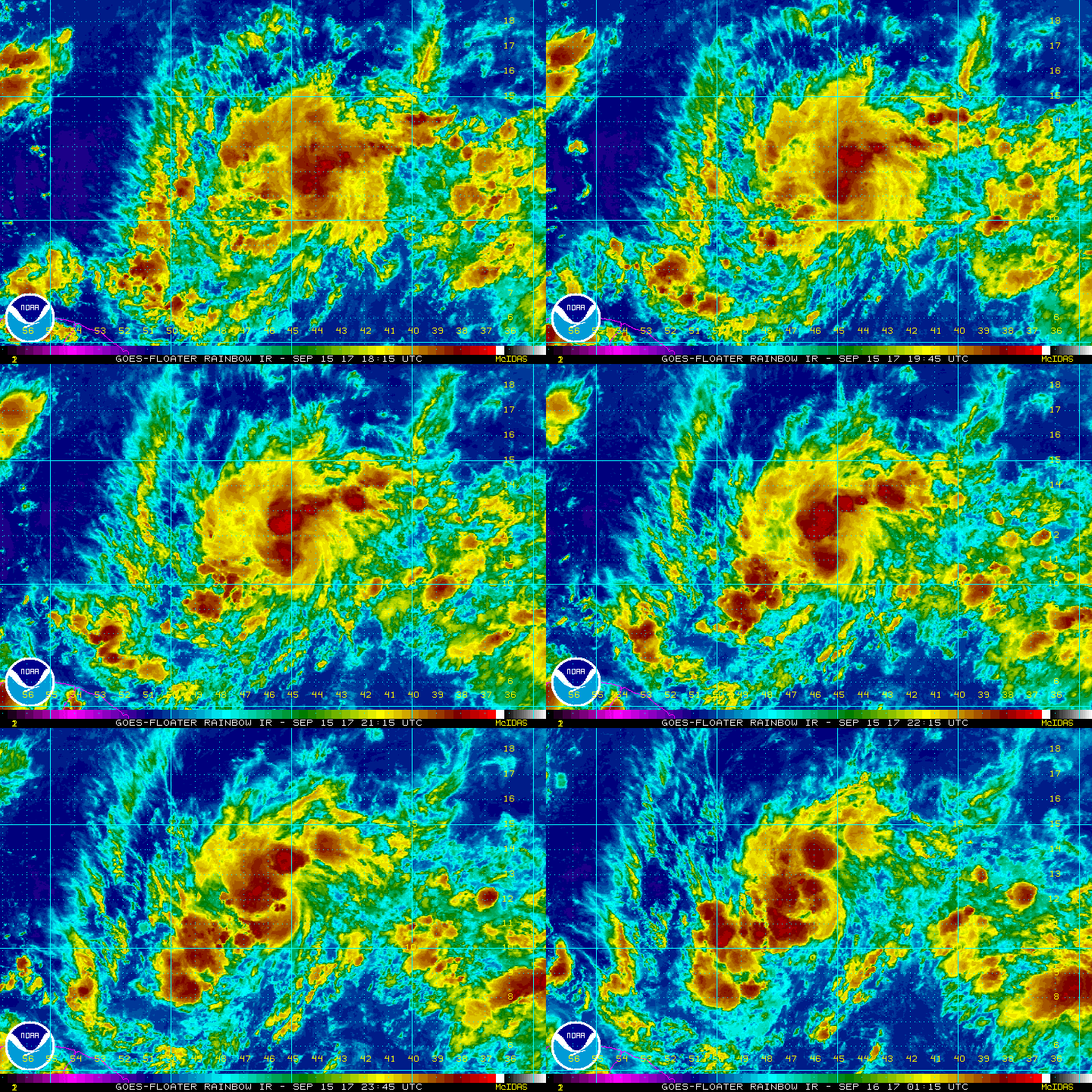
 
yeah Jose sure exited stage right

Its going to hit, probably a Cat 4 in the NW Bahamas at 204 hours
 
Definitely doubt it would come back that ferociously if it ran over Hispaniola as a strong major hurricane... That almost always doesn't go over well and cat 4-5 TCs that hit land, even if they have all the time in the world to come back, usually take their sweet time reintensifying after land interaction because the wind field broadens/flattens & a new inner core has to form as well which often takes at least 2-3 days... Plus it's the GFS...
 
the outflow on the GFS simulated IR is incredible, if it verifies it would have no problem bombing again
 
if that huge ridge develops behind Jose Florida is doomed

There's like no other scenarios other than it dying from the Shredder

UKMET Is Irma Part II through the Caribbean
 
Last edited:
UKMET ends north of Hispanola(whereas the GFS is over Hispanola), I don't have any maps to show the pattern ahead though

Sure looks like an advisory is coming before long today and honestly this might be Lee instead of Maria

Showers and thunderstorms associated with a tropical wave located
about 800 miles east of the Windward Islands have continued to
become better organized. Environmental conditions are conducive for
additional development and a tropical cyclone could form at any time
today or Sunday so while the system moves westward or
west-northwestward around 20 mph. Interests in the Lesser Antilles
and northeastern Caribbean should closely monitor the progress of
this system. Tropical storm or hurricane watches could be issued
for portions of the Lesser Antilles later this morning.

* Formation chance through 48 hours...high...90 percent.
* Formation chance through 5 days...high...90 percent.

$$
 
The outflow may be impressive on GFS IR in the SW Atlantic, but if this runs over Hispaniola, the inner core will be severely disrupted and its ambient wind field would expand and flatten following said land interaction, slowing intensification & generally resulting in a weaker, but much larger TC.
 
I think the best bet would be to
add ~30 mb to the GFS strength. I was hoping folks would be more convinced of that after what Irma didn't do. A 960 mb storm would be much more realistic here and would still be one heck of a storm, unfortunately. Due to biases as well as extreme levels of uncertainty that far out in time (9/25-6), I'm not really worried about my area being hit hard by those 2 models at this time.
 
HWRF has a major hurricane about to hit Puerto Rico at 120

HMON has a major hurricane just south of Puerto Rico at 120

Pressure in the 940s on both
 
0Z GEFS suggest that the 0Z GFS is a SW outlier being that it has many Carolina hits as well as further NE tracks. OTOH, the GFS may have a righward bias when dealing with a strong upper high to its north as occurred with Irma. Regardless, it is still 9-10 days away from the SE US if it were to hit. We'll have to see if Jose will be hanging out not too far away and protect the SE though the 0Z models don't show that so far.
 
I definitely agree that Jose is still the wildcard here... might be the only thing that saves the US
 
Euro major hurricane in the SE Bahamas at 168 with ridging building north and east

Almost the exact same spot as the GFS/CMC at the same time
 
Huge if whether or not 96L misses Hispaniola, if it manages to pass to the north as the UKMET/ECMWF suggest, then the intensity forecast the GFS was showing over the Bahamas and off the SE US coast is very feasible unfortunately...
~950 hPa category 3 by 174 hr
ecmwf_mslpa_swatl_30.png

ecmwf_ir_swatl_30.png
 
wow to see the Euro this bullish is quite amazing

Big big potential if it avoids the Shredder

The track consensus is pretty amazing too, this looks like it should be very similar to the GFS/CMC 10 days out!
 
This Euro run verbatim is very similar to the evolution of Hugo (1989) but again a lot of this hinges on 96L staying north of Hispaniola, if it doesn't then that changes everything....
 
looks like it will go up the coast(east of Hugo) assuming the 240 hour Euro verified(not likely lol)
 
Back
Top