Discuss the 3/17/21 outbreak here. 3/18 can be discussed in the existing thread
-
Hello, please take a minute to check out our awesome content, contributed by the wonderful members of our community. We hope you'll add your own thoughts and opinions by making a free account!
You are using an out of date browser. It may not display this or other websites correctly.
You should upgrade or use an alternative browser.
You should upgrade or use an alternative browser.
Severe 3/17/21 Severe Weather Outbreak Al/Ms/Tn/Ar nowcast
- Thread starter SD
- Start date
Z
Zander98al
Guest

Warm sector cloudy in my local
DadOfJax
Member
Perfect SD....much appreciated!
CCAir90
Member
Avid lurker here. I'm located in Jackson, TN, east-northeast of Memphis. Very much invested in today... may not be able to post much, due to work requirements (public safety), but will try to update for MBY.
Warm front appears to be passing over right now. It's weird outside, too... you can tell something is amiss. Temp has risen dramatically this morning, and it's storming yet fog has formed in the past ~20 minutes. Frontal pressure trough passage and wind shift is ongoing, for those of you interested in the warm front's progress. I'll let you know if clearing gets going in earnest here in West TN.
(P.S. If you're a fellow West Tennessean, feel free to private message me. Or anyone, really, but you know") .)
.)
Warm front appears to be passing over right now. It's weird outside, too... you can tell something is amiss. Temp has risen dramatically this morning, and it's storming yet fog has formed in the past ~20 minutes. Frontal pressure trough passage and wind shift is ongoing, for those of you interested in the warm front's progress. I'll let you know if clearing gets going in earnest here in West TN.
(P.S. If you're a fellow West Tennessean, feel free to private message me. Or anyone, really, but you know
.)Oh ---- those MS temps
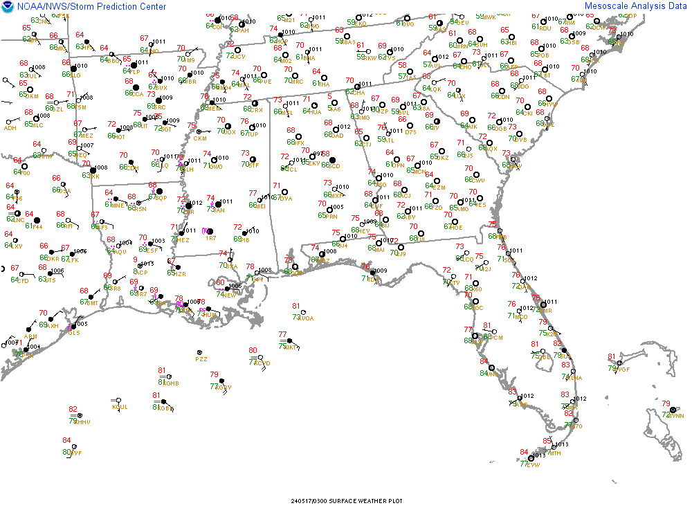
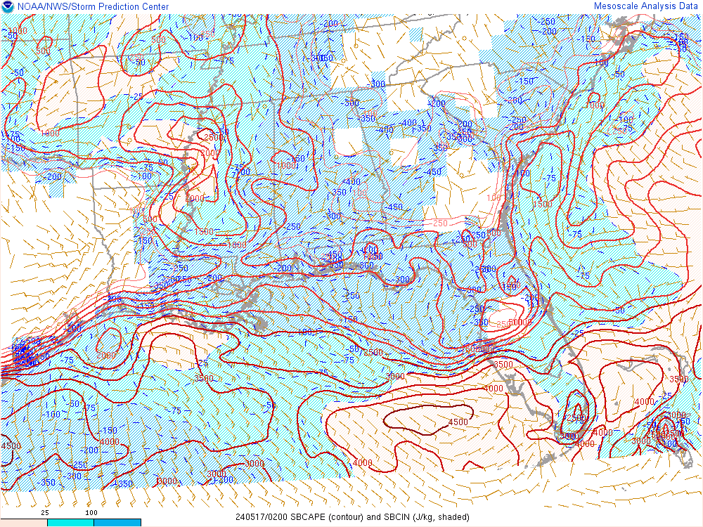
CAPE is surging
jdenmark
Member
We've had a good bit of rain, thunder and lightning in North Alabama all morning. Will that do anything to sap the energy from later storms for this part of the state?
Dewpoint Dan
Member
Guy on TWC says this could be similar to 4/27/11, although not quite as bad
13z HRRR UH swaths

Guy on TWC says this could be similar to 4/27/11, although not quite as bad
Umm that's like Voldemort of Severe weather you just don't say it name... I hope for everyone sake he's wrong
blitzgunner
Member
It is still pretty cloudy in Birmingham. If the sun can’t break out today does that lessen the chance of tornadoes occurring?
12z BMX sounding. I imagine its got more of an inverted V look at low levels now since temp should be increasing

- Joined
- Jan 5, 2017
- Messages
- 3,806
- Reaction score
- 6,063
Based on the level of activity on this board and looking at current model trends, I don't believe them. Similar in that there may be tornadoes in the same areas, but not the same as in every freaking storm that fired up made a giant wedge like in 2011.Guy on TWC says this could be similar to 4/27/11, although not quite as bad
Yeah I think that's a hard pass for me. My town got hit 2x and my county had the highest number of tornadoes in the state ?. Praying that this system busts but I know that's probably not gonna happen. Everyone stay safe over the next couple of daysGuy on TWC says this could be similar to 4/27/11, although not quite as bad
It is still pretty cloudy in Birmingham. If the sun can’t break out today does that lessen the chance of tornadoes occurring?
Unless the wedge hangs in, no.
Dewpoint Dan
Member
I just pray that nobody dies and everyone who lives in a mobile home does the smart thing by finding a sturdier building.Yeah I think that's a hard pass for me. My town got hit 2x and my county had the highest number of tornadoes in the state ?. Praying that this system busts but I know that's probably not gonna happen. Everyone stay safe over the next couple of days
Jrips2710
Member
I’d say it can’t hurt us to have less sun. That should only be a positive if you’re looking for less severe. But honestly it probably won’t matter due to the other dynamics at play later. Starting to get some breaks in the clouds per satellite in areas north and east of Birmingham.It is still pretty cloudy in Birmingham. If the sun can’t break out today does that lessen the chance of tornadoes occurring?
Strong wording

DadOfJax
Member
You are basing your opinion of them being wrong on weather board traffic? BWAHAHAHAHABased on the level of activity on this board and looking at current model trends, I don't believe them. Similar in that there may be tornadoes in the same areas, but not the same as in every freaking storm that fired up made a giant wedge like in 2011.
Jrips2710
Member
From BMX

HSVweather
Member
It’s all going to depend how far the warm front comes north, higher dewpoints, SBCAPE. I’ve been streaming Brad Travis on Facebook live as he has been discussing and showing various models.We've had a good bit of rain, thunder and lightning in North Alabama all morning. Will that do anything to sap the energy from later storms for this part of the state?
Dewpoint Dan
Member
It says it will peak this evening into tonight. Isn't it unusual for it to peak in the night time hours ? I wonder why it will be stronger tonight than during the day today ?
HSVweather
Member
I’m watching the SPC meso surface one page as well that has the temp/dew pointsIt’s all going to depend how far the warm front comes north, higher dewpoints, SBCAPE. I’ve been streaming Brad Travis on Facebook live as he has been discussing and showing various models.
HSVweather
Member
Better dynamics come into play tonightIt says it will peak this evening into tonight. Isn't it unusual for it to peak in the night time hours ? I wonder why it will be stronger tonight than during the day today ?
Dewpoint Dan
Member
But there will be less daytime heating though so wouldnt that offset the better dynamics ?Better dynamics come into play tonight
49 weather
Member
In 1974 the town of Guin was hit by an F5 (term used then) just after 9 pm and it was 69 degrees at the time.
HSVweather
Member
Below is pasted from the latest day 1 textBut there will be less daytime heating though so wouldnt that offset the better dynamics ?
By late afternoon and into early tonight, a low-level jet segment
will strengthen to 50-60 kt across MS/AL and the midlevel trough
approaches from the west, contributing to very strong low-level
shear (0-1 km SRH of 400-500 m2/s2). Buoyancy will be slow to
decrease after sunset and with eastward extent based on the
prevalence of upper 60s dewpoints, while very favorable wind
profiles will maintain the threat for long-track, intense tornadoes
with both warm sector supercells, as well as supercells within the
broken band along and ahead of the surface wind shift progressing
eastward across MS by early tonight. West central GA appears to be
the eastern edge of the primary severe threat area through tonight.
DadOfJax
Member
NO NO NOBut there will be less daytime heating though so wouldnt that offset the better dynamics ?
HSVweather
Member

development south of Tuscaloosa
Its awful early. Could this be considered warm sector contamination?View attachment 79297
development south of Tuscaloosa
Latest HRRR has a supercell riding the boundary north of BHM. That isn’t good.

Z
Zander98al
Guest
??Latest HRRR has a supercell riding the boundary north of BHM. That isn’t good.
accu35
Member
Anyone have a hail map for the southeast?
With the steep mid-level lapse rates in place and strong LLJ, I'm not convinced the extensive cloud cover will make a difference.
EDIT: Especially with the warm sector relatively lacking in ongoing activity.
EDIT: Especially with the warm sector relatively lacking in ongoing activity.
farleydawg792
Member

Jrips2710
Member