Storm5
Member
Good luck !
Sent from my iPhone using Tapatalk
Sent from my iPhone using Tapatalk

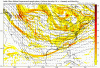
I’m trying to figure out what’s going on w such a narrow band when it appears precip shield is much larger. Anyone??
Same , on a on topic note ahhhh personally I’ll pass on the snow twc forecast for the weekend looks mild and sunny. I want to hike! Best of luck to CAE .Got a pop up add for resteraunt outdoor seating tents . Lol
How does this go from out of nowhere to this and it’s 3 days away?Good luck !
Sent from my iPhone using Tapatalk
Maybe but it looked (if I visualized correctly) as if precip shield extended further N within that NAM run. Maybe I was wrong. It’s just a wierd strip for our area and climatology. Not unheard of but not the norm either.Could it be the cold air has it suppressed?
Sent from my iPhone using Tapatalk
Hard to even take this serious at all. What in the world is happening. Trying to look at the temps for this time frame now.Enjoy it midlands. One or two more ticks NW and your out of the game. LOL!

Sent from my iPhone using Tapatalk
Yeah I’m struggling to rationalize that thin ltl band of precip w what appeared to be a bit more robust precip shield.Hard to even take this serious at all. What in the world is happening. Trying to look at the temps for this time frame now.

It's just a matter of the NW edge of precip close enough to coldest thermals for snow, if precip further NW would be a wider swath of snow.Yeah I’m struggling to rationalize that thin ltl band of precip w what appeared to be a bit more robust precip shield.
I would highly advise you to take a peek at the nam 3k. I think that may have a better handle of this atmHard to even take this serious at all. What in the world is happening. Trying to look at the temps for this time frame now.
Why?I would highly advise you to take a peek at the nam 3k. I think that may have a better handle of this atm
All the models including ensembles who have seen this storm paint a similar picture but in different locations .. a semi thin stripe that sets up where rates are good and temps are marginal enough .. makes for a good paste event but also makes for a very hard to track storm ... lots of ups and downs with this one I’m sure .. a good appetizer for the King Kong event
From previous experience i thought the 3k nam had better thermals?Why?
Banter....help me out here Charlie!!Side note , King Kong 100 percent has to be the thread name for next weeks storm .
Sent from my iPhone using Tapatalk
You’re at the end of its range so no. The 3K should not be looked at. You’re right in the 12K perfect range.From previous experience i thought the 3k nam had better thermals?
It did and then they had it offline till 12z today. So who knows what it was seeing all along past couple days. It cant be worse than what its replacing.If this works out gonna have to really start looking at the new GFS more, it picked it up first I believe. Would be another score
Well, it was only the northwest periphery of the precipitation field that was snow. The precip field itself was much more expansive to the south and east.I’m trying to figure out what’s going on w such a narrow band when it appears precip shield is much larger. Anyone??
.png")
Yeah I'm fairly certain @57 it wasn't showing snow with the last system. It maybe right but I'm looking at v16, ensembles and NAM just starting to latch on...trends not bad.From previous experience i thought the 3k nam had better thermals?
What's this mean?Around Montgomery. Oh buddy....
The storm itself has been there for a while. People just wanted to look at the D10 shiny object, I guess, haha. However, this is the first run of any model I’ve seen that’s showed snow for CAE, MCN, etc. Most other modeling has confined potential snow to portions of NC.How does this go from out of nowhere to this and it’s 3 days away?

I love it but will likely mean instant doom I fear.....Side note , King Kong 100 percent has to be the thread name for next weeks storm .
Sent from my iPhone using Tapatalk