L
Logan Is An Idiot 02
Guest
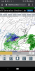
Okay whatever you say.The HRRR shows a very grim picture for most of western NC...and radar trends are confirming it.
Okay whatever you say.The HRRR shows a very grim picture for most of western NC...and radar trends are confirming it.
yea pouring hereNot going to lie The CAE radar looks way more impressive than expected right now and if that stuff keeps coming north we will have something here by midnight
The HRRR shows a very grim picture for most of western NC...and radar trends are confirming it.

The 0Z HRRR looks very good for majority of WNC. Extreme SW NC maybe not so much but there wasn’t much forecasted there to begin with.The HRRR shows a very grim picture for most of western NC...and radar trends are confirming it.
Might I suggest a relaxing stroll to the whamby thread?The HRRR shows a very grim picture for most of western NC...and radar trends are confirming it.


BruhThat thang beautiful View attachment 64116View attachment 64117
Yea looks awful...cmon nowThe HRRR shows a very grim picture for most of western NC...and radar trends are confirming it.

I've had more heavy cold rains here so far this winter than I can ever rememberyea pouring here
The 0Z HRRR looks very good for majority of WNC. Extreme SW NC maybe not so much but there wasn’t much forecasted there to begin with.
Then enjoy!Maybe check the forecasts before making that statement. Where I’m at was forecast 2-4 tonight with an additional 4-8 tomm.

Radar does look good. I’m at 37° Near Dawson. Hoping for somethingReturns starting to build again to the south and west. Just wet so far at 36F. @EmersonGA , Bartow is starting to look better!


32 and pancakes falling.
Dry as a bone where we are suppose to have 8+ in Haywood CountyYea looks awful...cmon now
View attachment 64118
Well before the event has startedDry as a bone where we are suppose to have 8+ in Haywood County
Ive always wondered that too. However, in the summer if storms form down in the Troy-Albemarle region they survive well into Chatham Co.Me and @metwannabe sitting pretty and dry ! At least from the maps y’all posted today . That really blows . I always wondered if there is some sort of downsloping affect due to the Uwharries and Carraway ranges in central NC.

I’m not feeling too optimistic. Even though I’m under a winter storm warning, I can see a path to end up with almost nothing to show for it. Too much warm nose on the initial feed with maybe a burst of snow that doesn’t accumulate, dry slot/ drizzle in the middle, and the deform band fizzles so that I see light snow for a couple of hours that doesn’t accumulate much. Maybe get a heavy dusting to a 1/2” a couple of times. I really hope this doesn’t happen, but I’d give it a 50% chance of happening.


Can you back that up to show the max on the NC TN border? Maybe I am missing something...since everyone seems to think I’m a clown.Accounting for low ratios, this is a solid 1-2 with a isolated 3 under that band View attachment 64124

Thanks for the vote of confidence. It makes me feel better. I know if the rates are heavy it will pile up quickly. Little bit of luck involved. My area is always significantly worse than Greensboro and Winston. Mixing issues with every storm. I’m keeping my fingers crossed. It’s going to be tough teaching from my computer tomorrow...You probably are in the best spot outside of the mountains. I think you atleast see 2-3” of snow/sleet.
HrrrHonest question. Which model is more reliable. HRRR or RAP?
HRRRHonest question. Which model is more reliable. HRRR or RAP?
Me and my buddy @metwannabe are going to climb up to the top of Medoc mountain for some elevation and a better chance . It’s only like 350 feet up but perhaps that will do . It’s better than my 270 and his probably 150 feet of elevation . Actually not a bad idea ! Hmmm. Maybe some orographic lift?This is pain for Raleigh.
View attachment 64127
Can you back that up to show the max on the NC TN border? Maybe I am missing something...since everyone seems to think I’m a clown.


For sure, if it verifies. These bands are tricky things to forecast, but damn that looks good!!That’ll get the job done for areas around Charlotte View attachment 64125View attachment 64126
38 here. Hopefully some of the heavier returns can bring some more flakes.Returns starting to build again to the south and west. Just wet so far at 36F. @EmersonGA , Bartow is starting to look better!
The best part for me and the rest of us on the Hwy 74 corridor east of Charlotte is that this band looks to arrive within about an hour of sunset. So for the most part this should be after daylight which will be good with temps where they’re at.
Yea...that’s what I was thinking. Not good at all from Asheville west.
If the nam is good, I might have to change my map, thing has went from a GSO-RDU to a CLT-FAY type thingThe best part for me and the rest of us on the Hwy 74 corridor east of Charlotte is that this band looks to arrive within about an hour of sunset. So for the most part this should be after daylight which will be good with temps where they’re at.