-
Hello, please take a minute to check out our awesome content, contributed by the wonderful members of our community. We hope you'll add your own thoughts and opinions by making a free account!
You are using an out of date browser. It may not display this or other websites correctly.
You should upgrade or use an alternative browser.
You should upgrade or use an alternative browser.
Wintry February 7-8 Winter storm
- Thread starter Six Mile Wx
- Start date

Jessy89
Member
They never do
Is it snowing yet where your at
Sent from my iPhone using Tapatalk
Snowed In
Member
Rain mixing with snow here in Mcdonough, GA
- Joined
- Jan 2, 2017
- Messages
- 1,566
- Reaction score
- 4,279
This snowing here now!
NBAcentel
Member
This is where I think areas will have a shot at grassy accums today, latest hrrr is folding with more snow in the upstate, lol

Wulfer
Member
Up to 3.5 looks like this could be ending soon. 

GeorgiaGirl
Member
Based off a pic from a relative about 30 minutes ago, I'd say in areas that didn't melt they had gotten to a little over an inch in La Fayette, GA, and I know obviously from here they weren't far from areas that saw more (and may still get more).
I wonder if MRX thinks the cat is already out of the bag for their case, although obviously people didn't realize it.
I wonder if MRX thinks the cat is already out of the bag for their case, although obviously people didn't realize it.
- Joined
- Jan 2, 2017
- Messages
- 1,566
- Reaction score
- 4,279
Yes..SNOWCan anyone in Walhalla or Westminster sc report what’s falling. Looks like heavy snow there on radar
Sent from my iPhone using Tapatalk
iGrey_X
Member
What’s your temp and dew point?This snowing here now!
The radar looks beautiful right now


I'm 80% rain now. We were all snow for about 10 minutes and the cars and roofs got covered, but now thats washed away. So we got everything lightly covered twice for 5 minutes before the mix came back. Fun event though for this terrible winter! I had conceded no flakes so this is a win
EDIT: Back to 80% snow again, i'm literally on the line.
Same story here. Keeps waffling back and forth from all snow to rain/snow mix to mostly rain to back to moderate snow. You’re doing better than me. Nothing has stuck here just wet outside. At least it’s pretty to look at.Back to all snow and the cars are already covered again. If we could just stay all snow I would probably already have an inch because the rates here have been great.
Falling fast, but still melting on pavement. Driveway has small patches of snow, road is just wet.
Snownut
Member
No but its getting awful dark. Its closeIs it snowing yet where your at
Sent from my iPhone using Tapatalk
Nervous here in clt. Here and bam both show all rain as it moves in.
- Joined
- Jan 2, 2017
- Messages
- 1,566
- Reaction score
- 4,279
34/32What’s your temp and dew point?
Dandruff and dimes flying!
Dropping cotton balls
I'm about 1/2 mile from that pic and I have a little over an inch on the ground.Out in the snow, Woodstock!
drfranklin
Member
- Joined
- Dec 1, 2016
- Messages
- 511
- Reaction score
- 760
34.7/24, clouds thickening
Snownut
Member
Flurries starting here NW pickens county upstate
Close enough to call an inch now with that last downpour. Roads are white.
Good excuse to go see the in-laws?? ?Mini 5 one and two !!

Sent from my iPhone using Tapatalk


Sctvman
Member
Ron Burgundy
Member
Wow - really dumping here now. Whatever happens from here it’s a win!

The snow is now at 1" at my location, crazy rates! Yeah, this is going to over perform!
NBAcentel
Member
Snow banding looks to be getting heavier as it’s heading into the upstate, around this time where it’s suppose to start bleak as it moves East on the hrrr, dont see that so far
34/28. Hurry up precip
LovingGulfLows
Member
- Joined
- Jan 5, 2017
- Messages
- 1,499
- Reaction score
- 4,100
Heavy snow right now.

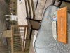
I guess it’s to much to ask my wife to take a pic from the large windows with no screens, but thankful she took one for me.
Northeast Cobb County
32.3F
1148’
Measured 4" in Chattanooga (in East Brainerd, about 1 mile south of Hamilton Place)

Sent from my SM-G930V using Tapatalk

Sent from my SM-G930V using Tapatalk
3.2 inches in Chatsworth. Heavy snow still falling.
Snowflowxxl
Member
Madness in Smyrna! Been pouring snow for last 20 min! Everything including roads covered! Awesome!!
LovingGulfLows
Member
- Joined
- Jan 5, 2017
- Messages
- 1,499
- Reaction score
- 4,100
The rates right now are insane here.
I can’t help but wonder if the little bit of sunshine this morning has maybe helped produce a little instability further east to give a little more in the way of convection and hold things together longer.Snow banding looks to be getting heavier as it’s heading into the upstate, around this time where it’s suppose to start bleak as it moves East on the hrrr, dont see that so far
LetItSnow
Member
Snow today, golf tomorrow; gotta love the South!!
.

Sent from my SM-G930V using Tapatalk

Sent from my SM-G930V using Tapatalk
RAP radar algorithm shows that there's a sharp cutoff between GSP and GA. Although this is the data that goes into the HRRR. I'm willing to bet that this is more so of snow?

,

Sent from my SM-G930V using Tapatalk

Sent from my SM-G930V using Tapatalk
NBAcentel
Member
Looking good so far