If more issues than rain, this could be worst than Dorian in the Midlands of SC.Possibly more than rain is the issue....icon began ramping it up this afternoon in that same spot. UK warned.
-
Hello, please take a minute to check out our awesome content, contributed by the wonderful members of our community. We hope you'll add your own thoughts and opinions by making a free account!
You are using an out of date browser. It may not display this or other websites correctly.
You should upgrade or use an alternative browser.
You should upgrade or use an alternative browser.
Tropical Major Hurricane Humberto
- Thread starter GeorgiaGirl
- Start date
Henry2326
Member
It depends on how long it has over water....as Phil says, can't really tell until or if it spins up. But we are T-2, so that's not a lot of time.If more issues than rain, this could be worst than Dorian in the Midlands of SC.
ForsythSnow
Moderator
Yes it's the first HWRF run, but this is what I want to see. Yes I want rain badly.

NE MOVEMENT ANYONE????
.gif")
ForsythSnow
Moderator
That's just some showers at the moment. The supposed circulation is somewhere in the middle of all that. It's still very disorganized.NE MOVEMENT ANYONE????
View attachment 23411
Henry2326
Member
Henry2326
Member
.png")
Downeastnc
Member
The real question is what happens IF it ends up east of Florida, does it sit and spin and wait to get kicked out or does it run N or NNW and hit GA up to NC.....
That scenario also adds a wind/surge component to the mix.....even a strong TS or weak cane sitting off the coast for a few days will pile the water up to the north of the center even if it is well offshore .....Hurricane Dennis stalled offshore of NC a good ways weakened to a TS then slowly drifted ashore but the long fetch of TS force winds helped to make him a top 5 surge event for the Pamlico River basin.
That scenario also adds a wind/surge component to the mix.....even a strong TS or weak cane sitting off the coast for a few days will pile the water up to the north of the center even if it is well offshore .....Hurricane Dennis stalled offshore of NC a good ways weakened to a TS then slowly drifted ashore but the long fetch of TS force winds helped to make him a top 5 surge event for the Pamlico River basin.
GeorgiaGirl
Member
I thought I saw a very broad circulation earlier today but I might've been seeing things, I just had it up for about a minute and couldn't locate one.
But anyway my motive is weak TS/TD to potentially see rain relief though...
But anyway my motive is weak TS/TD to potentially see rain relief though...
THATS WHERE I SEE SOME BROAD CIRCULATION. CAN ANYONE SEE ANYTHING DIFFERENT?? IF SO PLEASE POINT IT OUT.. THESE DISORGANIZED SYSTEMS ARE HARD TO PINPOINT THE "CENTER"

Right now the Gulf solution is the most practical. East of Florida solution is possible but ATM it’s wish casting.
There’s been still another significant NE shift of tracks on the 18Z Euro ensemble. Now the mean track is just inland of the FL E coast moving NNW. The mean strength is also significantly stronger than prior runs. Individual members are split between many that go NNW/N over the FL peninsula/GA and now a good number of others offshore in the Atlantic (some later hit Carolinas while others never make landfall). Mean rainfall for the 51 members maxes at a whopping 3-4” over NE FL/far SE GA.
That's possible but bigger key will be to see if that area of convection firing to the east can persist overnight if so any center would likely be relocated into that regionTHATS WHERE I SEE SOME BROAD CIRCULATION. CAN ANYONE SEE ANYTHING DIFFERENT?? IF SO PLEASE POINT IT OUT.. THESE DISORGANIZED SYSTEMS ARE HARD TO PINPOINT THE "CENTER"
View attachment 23413
Sent from my SM-G975U using Tapatalk
Henry2326
Member
Look up a couple of posts to the tweet I posted. He identified the same spot as you.THATS WHERE I SEE SOME BROAD CIRCULATION. CAN ANYONE SEE ANYTHING DIFFERENT?? IF SO PLEASE POINT IT OUT.. THESE DISORGANIZED SYSTEMS ARE HARD TO PINPOINT THE "CENTER"
View attachment 23413
I don't know how it's wishcasting when there are plenty of ensembles/models showing some variation of that idea. Wishcasting would be saying the ridge is going to be stronger and the storm is going to HoustonRight now the Gulf solution is the most practical. East of Florida solution is possible but ATM it’s wish casting.
Sent from my SM-G975U using Tapatalk


I don't know how it's wishcasting when there are plenty of ensembles/models showing some variation of that idea. Wishcasting would be saying the ridge is going to be stronger and the storm is going to Houston
Sent from my SM-G975U using Tapatalk
ATM is the key word. Until I see a large shift or even more gradual shifts, and the majority of Globals and or mesoscale models are in good agreement I’m not going out and saying east coast watch. While we are trending in that direction majority of data in in the Gulf. We will just have to wait and see. Wish casting probably wasn’t he best word to use, however I’m not buying the EC data just yet.
Henry2326
Member
Hey this one is going to Houston....does that count? Just kidding...lolI don't know how it's wishcasting when there are plenty of ensembles/models showing some variation of that idea. Wishcasting would be saying the ridge is going to be stronger and the storm is going to Houston
Sent from my SM-G975U using Tapatalk

Henry2326
Member
Heck I don't buy any of it yet....T-2....have no clue until T-2.ATM is the key word. Until I see a large shift or even more gradual shifts, and the majority of Globals and or mesoscale models are in good agreement I’m not going out and saying east coast watch. While we are trending in that direction majority of data in in the Gulf. We will just have to wait and see. Wish casting probably wasn’t he best word to use, however I’m not buying the EC data just yet.
Stormsfury
Member
Right now, gauging where a dominant circulation in this near term will set up is the biggest key right now.
Hence what I was saying before. These systems tend to get sneaky strong. This ridge looks a bit stronger and holding longer. No matter where it goes there is a good chance of landfall across the SE states IMO at this moment.
Bingo!!Right now, gauging where a dominant circulation in this near term will set up is the biggest key right now.
This morning Levi said it was or will be east tilted with the convection..and he believes the models will show the storm slowing down. Slower movement will likely mean a different track than what models have been showing over the last several runs.
Downeastnc
Member
There’s been still another significant NE shift of tracks on the 18Z Euro ensemble. Now the mean track is just inland of the FL E coast moving NNW. The mean strength is also significantly stronger than prior runs. Individual members are split between many that go NNW/N over the FL peninsula/GA and now a good number of others offshore in the Atlantic (some later hit Carolinas while others never make landfall). Mean rainfall for the 51 members maxes at a whopping 3-4” over NE FL/far SE GA.
The east of Florida track would be crazy especially if it made it to cane status and tracked right on the coast or actually landfall's somewhere.......then what a week or so later we would have yet another system potentially impacting.....the thing is that at this point ANY system close to or on the SE coast will be salt in the wound especially if it somehow makes it up to the OBX, the southern islands are a huge mess and another storm next week would immediately render all progress made up till then moot.
LickWx
Member
Appears this won’t really be stronger than Cat 1? I know it’s early to tell intensity forecasts but this won’t have enough time over water really to ramp up to major I’d reckon. Also, I’d love for a nice solid tropical storm to plow through the southeast bringing some much needed rain. Specifically piedmont of N.C./SC /GA . Eastern NC should be fine , farmers don’t need any more rain I reckon or that’s more crop damage after Dorian . Unless it’s moderate amount ( less than 4 inches spread out over 2-3 days).
The east of Florida track would be crazy especially if it made it to cane status and tracked right on the coast or actually landfall's somewhere.......then what a week or so later we would have yet another system potentially impacting.....the thing is that at this point ANY system close to or on the SE coast will be salt in the wound especially if it somehow makes it up to the OBX, the southern islands are a huge mess and another storm next week would immediately render all progress made up till then moot.
As it is, the strength increased quite a bit from the prior run, which had mainly TD to minimal TS. Now a good number are solid TS. Moreover, there are now several members at minimal H strength offshore the SE coast with the strongest one hitting Mrytle Beach area at what may be close to cat 2!
As always it will come down to timing.As it is, the strength increased quite a bit from the prior run, which had mainly TD to minimal TS. Now a good number are solid TS. Moreover, there are now several members at minimal H strength offshore the SE coast with the strongest one hitting Mrytle Beach area at what may be close to cat 2!
Now look at this upper high

accu35
Member
I just want rain
accu35
Member
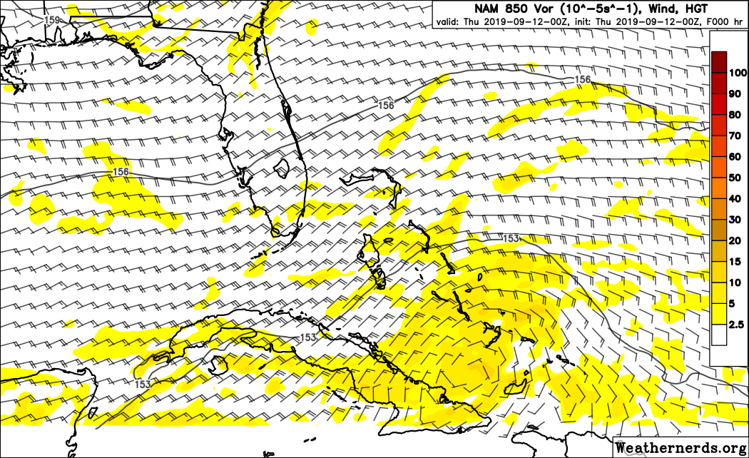
0z nam headed for the gulf
WELL THIS IS GOOD FOR BAMA FOLKS DEPENDING ON STRENGTH. ALSO LOOK AT THE TIP OF FL AT THE VERY END!!!!
.gif")
LickWx
Member
Be careful what you wish for , would be terrible for areas that haven’t seen a drop in weeks to suddenly get 6+ inches ! Not really having that problem in Raleigh though seems places further west are really dry however.I just want rain
I’m hoping for a low impact event with widespread moderate rains over a 2 day period .
Game changer for sure if a center relocates to that area of convection, if that happens all bets are offThat's possible but bigger key will be to see if that area of convection firing to the east can persist overnight if so any center would likely be relocated into that region
Sent from my SM-G975U using Tapatalk
Sent from my SM-G950U using Tapatalk
I may be wrong but believe the stronger 95l gets the higher the convection builds. The storm would be conflicted with more influence on the 250mb level. Therefore a potential NW track due to the strength of that upper high? Though the storm would have to be really strong to have major convection influxes that high?
Last edited:
accu35
Member
Downeastnc
Member
Early maps of the 0Z ICON suggest there may a slight east shift vs the prior run.
Edit: Later maps suggest there, indeed, is a decent east shift.
It definitely seems to favors the eastern "blob" for development out to 66 hrs now and still a tad bit east of last run.....thankfully it has it as a TD/weak TS at best as it moves over the Abaco's...
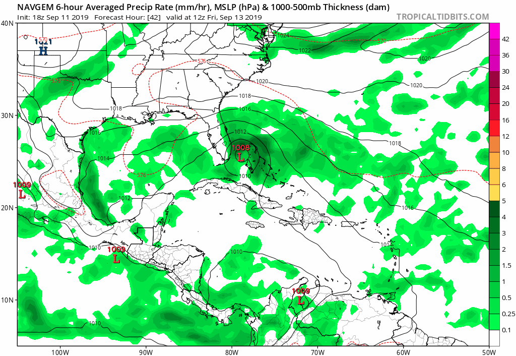
18Z NAVGEM
NBAcentel
Member
Early maps of the 0Z ICON suggest there may a slight east shift vs the prior run.
Edit: Later maps suggest there, indeed, is a decent east shift.
How unfortunate, rain is really becoming needed Around here, at least it’s only 1 run
GeorgiaGirl
Member
Have to think that ICON is probably too far east, but that kind of idea can't be ruled out until we see where the center ends up. Could end up relocating further east because the convection is higher there and if so all bets are off on what happens.
But look at us all wishing for rain lol...
But look at us all wishing for rain lol...