-
Hello, please take a minute to check out our awesome content, contributed by the wonderful members of our community. We hope you'll add your own thoughts and opinions by making a free account!
You are using an out of date browser. It may not display this or other websites correctly.
You should upgrade or use an alternative browser.
You should upgrade or use an alternative browser.
Tropical Hurricane Dorian
- Thread starter RBR71
- Start date
Is that the eye on the IR?

Yep, and the definite look of a strengthening cane.
Yuleeraptor
Member
Fernandina Beach/Amelia Island here. intently watching where this goes...I'm out towards Jax Beach, relocated from NJ like 5 years ago.
Didn't have any shortage on supplies here yet.
JaxHurricane12
Member
All of the stores here were nuts earlier.Fernandina Beach/Amelia Island here. intently watching where this goes...
Didn't have any shortage on supplies here yet.


pcbjr
Member
still spread out like a covey of quail on the first flush of opening day ...
Henry2326
Member
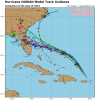
I'm curious....what are you expecting? I've been surprised at every round except 06z tonight.Same area as the Hurricane models.
Same area as the Hurricane models. Ready for the 0z tonight
accu35
Member
Not saying it wouldn't happen, I'm just saying it's the Navy. Maybe you'll get your storm, your area has had no action in a while.I have seen times where the Navy have been right.
accu35
Member
I understand, I was just pointing out the similarities hereI'm curious....what are you expecting? I've been surprised at every round except 06z tonight.
SWVAwxfan
Member
Man. Some of those plots are awfully close to SW VA. What a mess that would be.
pcbjr
Member
Not oversimplifying, ignoring other factors, or making a statement, except, it's still a wonky bowl of soup in the pot ...


ForsythSnow
Moderator
Probably starting to RI. Unfortunately the data is missing for the last eye pass except for the eye drop. We got a 4 - 6 mb drop in pressure in the time between.

Probably starting to RI. Unfortunately the data is missing for the last eye pass except for the eye drop. We got a 4 - 6 mb drop in pressure in the time between.
Isnt that like 986mb accounting for the wind?
ForsythSnow
Moderator
They pinned it as 988mb, but seeing what the advisories have been going by, it'll be at least that at 11 pm. I think it's intensification has sped up.Isnt that like 986mb accounting for the wind?
SimeonNC
Member
So, what are the chances that Dorian becomes a Cat 2 tonight?


Jessy89
Member
So, what are the chances that Dorian becomes a Cat 2 tonight?
I think it might be by 5am maybe
Sent from my iPhone using Tapatalk
They pinned it as 988mb, but seeing what the advisories have been going by, it'll be at least that at 11 pm. I think it's intensification has sped up.
Agree. Dorian is getting into the best conditions its ever had currently. If it does the waltz right the next 72 hours between the ull moving sw and hp building from its NE, then no doubt itll hit and exceed cat 4 status
ForsythSnow
Moderator
Overnight I think it'll make the run up to 100 mph. It seems to be prepping for that now.So, what are the chances that Dorian becomes a Cat 2 tonight?
pcbjr
Member
I swear I do not do hallucinogens, but that is trippy ...18Z EPS 132 vs 12Z EPS 138 vs 6Z EPS 144 vs 0Z EPS 150:
18Z at 132:
View attachment 22252
12Z at 138:
View attachment 22253
6Z at 144:
View attachment 22254
0Z at 150:
View attachment 22255
18Z EPS 132 vs 12Z EPS 138 vs 6Z EPS 144 vs 0Z EPS 150:
18Z at 132:
View attachment 22252
12Z at 138:
View attachment 22253
6Z at 144:
View attachment 22254
0Z at 150:
View attachment 22255
Definitely zeroing in between CC and Miami.
Was the 18z a further south or further now move its hard to tell?18Z EPS 132 vs 12Z EPS 138 vs 6Z EPS 144 vs 0Z EPS 150:
18Z at 132:
View attachment 22252
12Z at 138:
View attachment 22253
6Z at 144:
View attachment 22254
0Z at 150:
View attachment 22255
325
URNT15 KNHC 290052
AF302 1205A DORIAN HDOB 22 20190829
004230 1931N 06600W 6967 03149 0068 +079 +016 053038 038 039 000 03
004300 1930N 06559W 6969 03144 0064 +081 +017 052039 041 040 000 00
004330 1929N 06558W 6965 03146 0067 +076 +017 056034 038 039 000 00
004400 1928N 06557W 6963 03146 0063 +077 +018 056033 034 042 000 03
004430 1926N 06555W 6963 03139 0063 +072 +018 045031 033 047 002 00
004500 1925N 06554W 6969 03129 0045 +082 +018 041038 041 048 000 03
004530 1924N 06553W 6966 03120 0025 +088 +019 034044 045 050 003 00
004600 1923N 06551W 6967 03108 0003 +095 +019 028043 045 061 019 00
004630 1921N 06550W 6959 03098 9981 +093 +019 023052 060 061 022 00
004700 1920N 06548W 6984 03043 9977 +076 +020 355039 054 063 030 03
004730 1918N 06547W 6934 03107 9920 +122 +020 335022 039 048 009 00
004800 1917N 06545W 6982 03042 9904 +134 +022 300013 019 024 000 03
004830 1918N 06544W 6970 03054 9900 +135 +023 175013 022 025 000 00
004900 1919N 06542W 6964 03064 9909 +130 +025 154030 032 034 000 03
004930 1920N 06541W 6968 03063 9915 +127 +027 152031 033 033 000 03
005000 1920N 06539W 6973 03062 9930 +119 +029 159036 039 073 003 00
005030 1919N 06538W 6968 03075 9955 +103 +030 173045 048 075 004 00
005100 1917N 06537W 6957 03098 0010 +071 +031 194063 065 072 004 00
005130 1916N 06536W 6974 03092 0041 +060 +031 199059 064 067 007 00
005200 1915N 06535W 6965 03122 0057 +061 +028 203052 056 060 006 00
$$
Latest recon data has the SFMR wind at 75 knots.
I really hope we don’t get no storm. Too many family members here man. Charleston can barely take a summer storm without flooding.Not saying it wouldn't happen, I'm just saying it's the Navy. Maybe you'll get your storm, your area has had no action in a while.
farleydawg792
Member
Radar out of PR
AL, 05, 2019082900, 03, OFCL, 3, 197N, 660W, 75, 986, HU,
Winds up to 85 mph and the pressure down to 986 mb.
Winds up to 85 mph and the pressure down to 986 mb.
Brent
Member
18z EPS

Jessy89
Member
Euro has the best handling of this storm. Sure it’s adjusted some but there has not been any major swings
Sent from my iPhone using Tapatalk
Was the 18z a further south or further now move its hard to tell?
The mean of the ~51 members is neither S or N. The mean is actually a bit further E than the prior runs due to more members lagging behind.
Dorian almost has that "fist" look to him....
pcbjr
Member
Thanks Brent ... but not for the mean ... LOL
Snowflowxxl
Member
Galaxy's Edge is going to get crushed 
eye looks to be closing off, poss trying to go thru an EWRC

SUMMARY OF 1100 PM AST...0300 UTC...INFORMATION
-----------------------------------------------
LOCATION...19.7N 66.0W
ABOUT 90 MI...145 KM N OF SAN JUAN PUERTO RICO
MAXIMUM SUSTAINED WINDS...85 MPH...140 KM/H
PRESENT MOVEMENT...NW OR 320 DEGREES AT 13 MPH...20 KM/H
MINIMUM CENTRAL PRESSURE...986 MB...29.12 INCHES
SWVAwxfan
Member
It's really looking rough on radar. That dry air is really giving it a good fight.
pcbjr
Member
Just a tad north at 11:00 ... or so it seems ...


We can all tell where it should be going in the short term at least...***current steering level***
