I would be fine with this storm being where it is on Sunday at 12z, as the NW trend has shifted storms quickly in the past. We've got plenty of runs left for it to moveMan the GFS really isn’t even close. We have to get this thing shitfting NW quick
-
Hello, please take a minute to check out our awesome content, contributed by the wonderful members of our community. We hope you'll add your own thoughts and opinions by making a free account!
You are using an out of date browser. It may not display this or other websites correctly.
You should upgrade or use an alternative browser.
You should upgrade or use an alternative browser.
snowlover91
Member
CMC is pretty close, it's been gradually nudging NW over the past few runs.
NorthGaWinter4
Member
Early on the CMC but it has light precip breaking out in SMS maybe it’s gonna make a run at it
Yeah I think it’s pretty obvious the direction our cold air is coming..late but never denied smhAh, gosh. The ICON maps were slow. There is some snow... not here in Hell of course..
View attachment 16910
snowlover91
Member
Here's a 6 run trend of the Fv3, definitely small steps in the right direction.

snowlover91
Member
It has light precip but nothing much. It did shift the low a little closer to the coast with a little better precip.Early on the CMC but it has light precip breaking out in SMS maybe it’s gonna make a run at it

The cold dry stable air next week is going to cause any future storm to produce winter esp VA/NC mountains and foothills. May lose out of the first storm in the mountains but the cold air will lock in at the surface and snow cover will be laid down to our north. A recipe for a significant March winter storm.
Webberweather53
Meteorologist
We're already closer to getting an actual storm here compared to the mid-late January coastal that barely missed NC to the east. This is a pretty decent spot to be in 5 days out & I like the way we're headed on the past run or two.
ATLwxfan
Member
We need the low to cut a touch more inland but not too far. You really want The I-95 big cities to be just outside of the rain snow line. A narrow miss for them would be like chicken soup for our southern souls.
Sent from my iPhone using Tapatalk
Sent from my iPhone using Tapatalk
snowlover91
Member
We're already closer to getting an actual storm here compared to the mid-late January coastal that barely missed NC to the east. This is a pretty decent spot to be in 5 days out & I like the way we're headed on the past run or two.
Yeah I agree. What the GFS and CMC have is already closer to the coast than any of the models showed for that January coastal miss and we still are 5 days out which is plenty of time to see positive improvements. Hopefully the UK can hold serve and the Euro will adjust NW some, I'd like to see it start ticking north now.
The NW trend has been about the only reliable thing to count on all winter. No way I would bet against it now.I am expecting things to start shifting NW quickly by Sunday.
B
Brick Tamland
Guest
We're already closer to getting an actual storm here compared to the mid-late January coastal that barely missed NC to the east. This is a pretty decent spot to be in 5 days out & I like the way we're headed on the past run or two.
Yeah I agree. What the GFS and CMC have is already closer to the coast than any of the models showed for that January coastal miss and we still are 5 days out which is plenty of time to see positive improvements. Hopefully the UK can hold serve and the Euro will adjust NW some, I'd like to see it start ticking north now.
I am expecting it to start shifting NW quickly by Saturday.
snowlover91
Member
Really hard to tell what the UK shows with the 24 hour panels.
snowlover91
Member
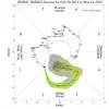
The critical 120 hour panel on the Meteocentre website is stuck on 12z Wednesday initialization instead of today. Looks like it might have something good though based off what 144 shows, anyone got those sideways maps of it?
snowlover91
Member
Here we go, hour 120.

Woah. Is that the low in question on that UKMET run down in the gulf (getting picked up)? If so, that may be a glorious track. Can't tell if it's just placing lower pressure there and it's not the main bundle that pops off the SE coast or not. I'd assume we wouldn't be that lucky down here and it's going to "jump" off the SC/NC coast and no surface low will take a track across FL.
snowlover91
Member
Woah. Is that the low in question on that UKMET run down in the gulf (getting picked up)? If so, that may be a glorious track. Can't tell if it's just placing lower pressure there and it's not the main bundle that pops off the SE coast or not. I'd assume we wouldn't be that lucky down here and it's going to "jump" off the SC/NC coast and no surface low will take a track across FL.
It's hard to tell with 24 hour panels but the next one shows a pretty strong low up in the northern Atlantic so I'm guessing it redevelops off the SC coast and then bombs out.

It's hard to tell with 24 hour panels but the next one shows a pretty strong low up in the northern Atlantic so I'm guessing it redevelops off the SC coast and then bombs out.
View attachment 16918
Yeah looking like it may just be placing 1014 in the Gulf, that's not quite true to form before holding it around 1012-1013 off SC/NC ..and strengthening it as it climbs northward. Hopefully we will have better maps soon. This may be a slightly colder run IRT 850s.
snowlover91
Member
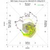
GEFS members still demonstrate a wide range of possible outcomes from complete whiffs to some pretty amped options.

accu35
Member
Here's frame further south

snowlover91
Member
Overall though the snow totals are not that impressive on any GEFS members and it seems to have taken a small step back from the 6z run.
If I'm reading this right, this looks like the location it officially takes/form starts to strengthen at: (yes, precip does get through SC & Western NC as this happens, but not sure on temps/type).. does look warm at the SFC.

12Z UKMET is heading towards the Euro and the rest of the suppressed camp. That's what I expected, but I guess there is still time for it to go either way.


NBAcentel
Member
GEFS members still demonstrate a wide range of possible outcomes from complete whiffs to some pretty amped options.
View attachment 16919
Ensemble 9 been pretty consistent ??
 ??
??dsaur
Member
Dang, it just rains all the time now. I like rain, much, much better than drought, but this is getting ridiculous. I'd trade some of my rain for some cold air. It's 60 just past noon, in Feb. If this is the new winter normal, I want my money back....or, I want 40's in July. It's only fair. If we'd even gotten half the winter cold I used to see in my youth, with half this rain, I'd still be sledding from Jan's storms. Can't get anything done outside anymore. It's either raining, or just finished raining, or getting ready to rain, but it never gets cold. 60 in Jan, or Feb, a few times, is normal, but this broken record, year after year, spells a cycle change, and as a cold air lover, I don't like it. I love anomalous weather, but this is getting to be the norm, and it's scary.
I continue to like where we stand as there's more ensembles showing a storm, including one that's rain for everyone, than ones that are whiffs. That shows that the "NW trend" is probably still well in the picture.
From Radiant this morning: both GEFS and EPS have continued to be too cold in the 11-15 by ~7 F/day in the SE during the last 30 days. I can't post the maps themselves. However, I can tell you that whereas the raw 0Z maps have the SE near normal for March 10-14, the bias corrected maps actually have a near torch in the SE then, especially the 6-8 F warmer than normal EPS, with very cold about 1,000 miles to our NW in parts of the Midwest and Plains. Note that Atlanta has had the strongest cold bias of the major cities mentioned:
"The maps at the top of this discussion are the raw and bias corrected data for the Euro EN in the 11-15 Day period. The bias corrected data takes into consideration the average bias of the past 30 Days, which include the model being too cold by 4.3° in Chicago, 2.6° in Dallas, 3.6° in Houston, 6.5° in Atlanta and 5.6° in New York City. The maps below are the same comparison but for the GFS EN. This model in the 11-15 day period has been too cold by 5.7° in Chicago, 3.1° in Dallas, 3.4° in Houston, 6.9° in Atlanta and 5.6° in New York City. If these biases remain, then our forecast may not be warm enough, especially in the South."
"The maps at the top of this discussion are the raw and bias corrected data for the Euro EN in the 11-15 Day period. The bias corrected data takes into consideration the average bias of the past 30 Days, which include the model being too cold by 4.3° in Chicago, 2.6° in Dallas, 3.6° in Houston, 6.5° in Atlanta and 5.6° in New York City. The maps below are the same comparison but for the GFS EN. This model in the 11-15 day period has been too cold by 5.7° in Chicago, 3.1° in Dallas, 3.4° in Houston, 6.9° in Atlanta and 5.6° in New York City. If these biases remain, then our forecast may not be warm enough, especially in the South."
Wouldn't most of that be from the SER which wasn't modeled properly? If that is out of the picture maybe the bias will not be as bad going forward?From Radiant this morning: both GEFS and EPS have continued to be too cold in the 11-15 by ~7 F/day during the last 30 days. I can't post the maps themselves. However, I can tell you that whereas the raw 0Z maps have the SE near normal for March 10-14, the bias corrected maps actually have a near torch in the SE then, especially the 6-8 F warmer than normal EPS, with very cold about 1,000 miles to our NW in parts of the Midwest and Plains. Note that Atlanta has had the strongest cold bias of the major cities mentioned:
"The maps at the top of this discussion are the raw and bias corrected data for the Euro EN in the 11-15 Day period. The bias corrected data takes into consideration the average bias of the past 30 Days, which include the model being too cold by 4.3° in Chicago, 2.6° in Dallas, 3.6° in Houston, 6.5° in Atlanta and 5.6° in New York City. The maps below are the same comparison but for the GFS EN. This model in the 11-15 day period has been too cold by 5.7° in Chicago, 3.1° in Dallas, 3.4° in Houston, 6.9° in Atlanta and 5.6° in New York City. If these biases remain, then our forecast may not be warm enough, especially in the South."
The SER has been a thorn in our side for years now it seems! I'm assuming its related to the NAO refusing to be negative in winter. However though, what if the SER is what's been actually forcing the trough near Greenland? Just a theory though. Anybody care to speculate?Wouldn't most of that be from the SER which wasn't modeled properly? If that is out of the picture maybe the bias will not be as bad going forward?
Wouldn't most of that be from the SER which wasn't modeled properly? If that is out of the picture maybe the bias will not be as bad going forward?
Well, look what has happened over just the last few days with the now Appalachian Rider projected for wave #1 along with a much warmer SE vs the weak southern slider and a cold SE that had been modeled just a few days ago. So, there still is no firm evidence that the cold bias has decreased yet at all, especially in the SE.
We desperately need to get out of this endless run of +NAO winters and see where we stand then.Dang, it just rains all the time now. I like rain, much, much better than drought, but this is getting ridiculous. I'd trade some of my rain for some cold air. It's 60 just past noon, in Feb. If this is the new winter normal, I want my money back....or, I want 40's in July. It's only fair. If we'd even gotten half the winter cold I used to see in my youth, with half this rain, I'd still be sledding from Jan's storms. Can't get anything done outside anymore. It's either raining, or just finished raining, or getting ready to rain, but it never gets cold. 60 in Jan, or Feb, a few times, is normal, but this broken record, year after year, spells a cycle change, and as a cold air lover, I don't like it. I love anomalous weather, but this is getting to be the norm, and it's scary.
From Radiant this morning: both GEFS and EPS have continued to be too cold in the 11-15 by ~7 F/day in the SE during the last 30 days. I can't post the maps themselves. However, I can tell you that whereas the raw 0Z maps have the SE near normal for March 10-14, the bias corrected maps actually have a near torch in the SE then, especially the 6-8 F warmer than normal EPS, with very cold about 1,000 miles to our NW in parts of the Midwest and Plains. Note that Atlanta has had the strongest cold bias of the major cities mentioned:
"The maps at the top of this discussion are the raw and bias corrected data for the Euro EN in the 11-15 Day period. The bias corrected data takes into consideration the average bias of the past 30 Days, which include the model being too cold by 4.3° in Chicago, 2.6° in Dallas, 3.6° in Houston, 6.5° in Atlanta and 5.6° in New York City. The maps below are the same comparison but for the GFS EN. This model in the 11-15 day period has been too cold by 5.7° in Chicago, 3.1° in Dallas, 3.4° in Houston, 6.9° in Atlanta and 5.6° in New York City. If these biases remain, then our forecast may not be warm enough, especially in the South."
If I remember, I'll bump this to see how warm the SE actually is March 10-14. If warm, then we know the cold bias had not let up. If near normal, then we know it had let up at least temporarily.
Anyone been seeing this... winter may not be giving up just yet ... the MJO seems to be pulling a u-turn and going back over towards the cold phases before it gets to the warm phases around the 15th or march ... would get interesting for sure (I bring this up because a bunch of y’all were freaking out about this the other day so now this should be a good thing to those people)
Attachments
Well hopefully that will change in March.Well, look what has happened over just the last few days with the now Appalachian Rider projected for wave #1 along with a much warmer SE vs the weak southern slider and a cold SE that had been modeled just a few days ago. So, there still is no firm evidence that the cold bias has decreased yet at all, especially in the SE.
By the way, the intense cold bias should still be giving some of you Carolina folks some hope that wave #2 will shift NW a good bit although the obvious question then would be whether or not it would still be cold enough for wintry. It could shift NW and be mainly rain in much of the Carolinas for all I know.
NBAcentel
Member
Gefs looks like it’s caving to the eps, ofc lol, starting to speed it up (trough) and less positively tilted which means a slimmer chance at overrunning but it’s better than what was happening yesterday, some of the gefs ensembles were saying MA storm due to it actually lagging behind a bit to much, also that bombing low in the top right/Newfoundland effecting this storm, notice now since it’s stronger, farther south, this thing is more suppressed/offshore


NorthGaWinter4
Member
Welp... was hoping for some good news from the 12z runs. Oh well
We toss?
We toss?
NBAcentel
Member
12Z Euro is a no for the 2nd wave for the SE it appears. Even further away from a threat. Actually, hardly anything there hour 126.
Looking off mslp maps this is the best I’ve probably Seen it in terms of less suppression, so I guess precip never made it ?
Looking off mslp maps this is the best I’ve probably Seen it in terms of less suppression, so I guess precip never made it ?
I've got access to 6 hour maps as well as closeups and I can assure you that that is not the case at all. The western edge of the measurable very light rain is actually slightly further offshore NC (150 miles) vs 100 miles offshore on the 0Z. Also, that nearest rain is very light/lighter than the prior run with only 0.05-0.10" within 150 miles of the NC coast.