cd2play
Member
But the pattern can't persist forever. Can it?We’ve been warmer than normal since December (brief PV cool down aside), I would bet on a warm March. Pattern persistence.
Sent from my iPhone using Tapatalk
But the pattern can't persist forever. Can it?We’ve been warmer than normal since December (brief PV cool down aside), I would bet on a warm March. Pattern persistence.
Sent from my iPhone using Tapatalk
The later in winter and into spring we go, the stronger the SE US ridge flexes its muscles under a -EPO, we're getting away w/ it here because we have a big PV lobe diving down into the Lakes, the wavetrain is so positively tilted in the Pacific & the wavelengths are short enough s.t. we end up w/ a general trough over the E US at least for now anyways. Latter stages of March could be a preview of summer given the way everything looks atm
I’m happy to see a Fellow Midlands Man back on.I actually have a sneaking suspicion that the chance for something Wintry down to I-20 could happen in a setup like this. I like the idea of the storm being on the majority of guidance in some form or fashion.
For example, I have noticed that the 12z Euro took a huge bump up in members with Wintry weather in the KCAE area to match what the GEFS members have been saying for many cycles now. I didn't count the members, but it might be even more happy about the idea vs other modeling.
But the pattern can't persist forever. Can it?
It will maintain pretty well across the board. I'm not expecting disappointment trends to start for a couple more days. Is an interesting 0z run though with the double whamy of having severe and snow chances back to back.I haven’t been this interested in a 00z model suite in a minute, what do you guys think will happen ?


ICON has actually done well lately, it was the only model to keep that chance of a “front end thump” we just got in NC then other models began to cave, but idk about it’s H5 scores


Gotta get cold first! Good to not see 300-400 mile shifts from run to runNot sure I like it already trending this much north, this far out.


FV3 and GFS look very similar. Hasn't happened very often this winter.

Here comes the main energy
Sent from my iPhone using Tapatalk
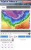
Wow so it’s two separate storm chances initial shot is trending north and the second shot looks to be the possible big dog.. look at the significant changes in the Gfs 500 mb charts ... looks VERY similar to 12z euro


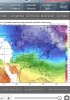
Looks suppressed which is much better then the gfs still got a little action from it though.Fv3 might be going boom here with the 2nd storm in a few frames.View attachment 16497