Yep next winter will be much dryer. Going to take a whole lot of healing. Also, while I still believe a solid snow storm is right on our door step, I am ignoring all the ice maps. There will be snow for the mtns and the actual watching is for the climo areas and like Winston to Raleigh. Cold rain elsewhere.
-
Hello, please take a minute to check out our awesome content, contributed by the wonderful members of our community. We hope you'll add your own thoughts and opinions by making a free account!
You are using an out of date browser. It may not display this or other websites correctly.
You should upgrade or use an alternative browser.
You should upgrade or use an alternative browser.
Yep next winter will be much dryer. Going to take a whole lot of healing. Also, while I still believe a solid snow storm is right on our door step, I am ignoring all the ice maps. There will be snow for the mtns and the actual watching is for the climo areas and like Winston to Raleigh. Cold rain elsewhere.
Yessssss!

Whole lot of healing lol
Looks like CMC pulled the trigger
Storm5
Member
00z cmc is all in


Sent from my iPhone using Tapatalk


Sent from my iPhone using Tapatalk
B
Brick Tamland
Guest
So, right now we have a possible storm on all the models. That hasn't happen since we actually had the storm in early December.
whatalife
Moderator
00z cmc is all in
Sent from my iPhone using Tapatalk
If only it wasn’t the CMC.

Sent from my iPhone using Tapatalk
Storm5
Member
If only it wasn’t the CMC.
Sent from my iPhone using Tapatalk
If the FV3 can get a storm right , any model can

Sent from my iPhone using Tapatalk
B
Brick Tamland
Guest
If only it wasn’t the CMC.

Sent from my iPhone using Tapatalk
Nice. The good thing is we actually have support for a storm from more than just the FV3. All of the models are showing the possibility now.
Storm5
Member
Gfs is close as well during the 3rd/4th period
Sent from my iPhone using Tapatalk
Sent from my iPhone using Tapatalk
NBAcentel
Member
Gfs is suppressed to hell, I like that
NBAcentel
Member
Feb 2014 ?

Storm5
Member
FV3 is close


Sent from my iPhone using Tapatalk


Sent from my iPhone using Tapatalk
NBAcentel
Member
FV3 is close
Sent from my iPhone using Tapatalk
I like where there are at now (FV, reg GFS), suppressed, not saying at all this storm will happen but with our past day 7-10 storms they trend northwest from the start, this look atm is def interesting tho....
NBAcentel
Member
Lol some of the gefs ensembles want to give some anafrontal flurries to MS/AL/TN later next week
NBAcentel
Member
Many folks are going to like the 0Z GEFS as it is the coldest of at least the last 4 runs when it has the 2+ waves of precip 3/4-5. Any weak surface lows associated with this precip are quite far south.
Nice to see a jump back colder, like I said earlier pattern is very flat at the time which would keep things more suppressed than normal, still just something I’m watching and not getting hopes up over


BHS1975
Member
Nice to see a jump back colder, like I said earlier pattern is very flat at the time which would keep things more suppressed than normal, still just something I’m watching and not getting hopes up over
View attachment 16397View attachment 16398View attachment 16399View attachment 16400
Siberian express right there.
Sent from my iPhone using Tapatalk
0Z GEFS
1. Generous qpf in and near the SE 3/4-5, especially considering we’re looking 9-10 days out:

2. Temps getting colder. If we could get anomalies 10 degrees colder than this, many could really be in business but at least this is going in the right direction: remember that we may be dealing with the coldest air in decades, if not of alltime records-wise in some cases, for early March in the Midwest (look at the big area of white!):

3. With cold enough air, this GEFS mean track would be absolutely golden for many (look how far SE is the mean low, the #1 requirement for snows that go deep down into the SE and are not just falling on the more typical northern sections):

1. Generous qpf in and near the SE 3/4-5, especially considering we’re looking 9-10 days out:
2. Temps getting colder. If we could get anomalies 10 degrees colder than this, many could really be in business but at least this is going in the right direction: remember that we may be dealing with the coldest air in decades, if not of alltime records-wise in some cases, for early March in the Midwest (look at the big area of white!):
3. With cold enough air, this GEFS mean track would be absolutely golden for many (look how far SE is the mean low, the #1 requirement for snows that go deep down into the SE and are not just falling on the more typical northern sections):
Definitely some heartier blocking going on on the euro so far
0Z Euro: Phil getting a cold rain with 28 degrees colder than normal 1 PM on 3/4 in the low 40s.
Edit: what a colder change vs 12Z; everything shifted much further south with the stronger early NW Canada block.
Now suddenly at 0Z, the Euro is the colder model for much of the SE.
**Edited for Phil's location
Edit: what a colder change vs 12Z; everything shifted much further south with the stronger early NW Canada block.
Now suddenly at 0Z, the Euro is the colder model for much of the SE.
**Edited for Phil's location
Last edited:
Does the Euro show any wintry wx?
Very close to something. Like the other models.Does the Euro show any wintry wx?

NW trend usually occurs so with this look it’s very hard not to get excited.Very close to something. Like the other models. View attachment 16413
Cad Wedge NC
Member
Nope, we lost the GFS and the FV3..... at least for this run. They are showing rainy cutters.Nice. The good thing is we actually have support for a storm from more than just the FV3. All of the models are showing the possibility now.
Not true every Model stil show storm signal with cold air around.Nope, we lost the GFS and the FV3..... at least for this run. They are showing rainy cutters.
NW trend usually occurs so with this look it’s very hard not to get excited.
The trend just from the last run was a big move SE, but it wouldn't be a surprise for a NW trend on the next run simply because that's how model typically go from run to run. Usually after a big move in one direction in just one run, the next one reverses at least some. This really was pretty close to a wintry event for much of the SE including deep south when considering @pcbjr is getting rain and only low 40s with 850s near +7 C and that there's significantly colder air at 850 not too far north of him. As it is on this run, the far northern extent of the rain shield in far S GA falls with 850s only near +3 to +4. It wouldn't take big adjustments from this run to have precip falling somewhere in the SE with 850's of 0C and even easier to see it with 850s of +1 to +2, which could support sleet with a similar setup.
NBAcentel
Member
Oh boy.... gfs needs to chill out


BufordWX
Member
Looking at how the month starts. The 00z Euro shows a wet start to the month with another series of storm systems from Thrs-Sat dropping another 2-5 inches of rain on the southeast. Given some of the flooding problems that have already occurred from this past week’s rain that’s the last thing some of us need.
NBAcentel
Member
im pretty sure AL/MS has had enough severe wx, that run of the gfs better be a off/fluke run
NBAcentel
Member
I’m just gonna leave this here, this is probably wrong since it still has time to change but it’s something to watch, closer than that potential winter storm


NBAcentel
Member
This is the type of far SE weak low track (as shown on the 0Z Euro below) that can give the deep SE a very rare snow even in early March if there’s a connection to cold air in the deep SE:
View attachment 16417
If you win, I win, idc If a storm whiffs to my south, you, areas around you, Phil and Columbia sc deserves it
What did the 0z EPS showed?
That is a few tweaks away from a much bigger problem than yesterdays system.
What did the 0z EPS showed?
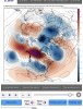
Deep SE folks are going to like the 0Z EPS as it, like the operational, shifted well SE on the cold and the mean surface low track as well as having ample qpf:
1. Like the operational, look how far SE the mean surface low is on the 0Z EPS:

2. Temperatures are significantly colder on the 0Z than the 12Z EPS with even much colder anomalies lurking a few hundred miles to the NW:

3. QPF is quite significant in the deep SE:

Last edited:
NBAcentel
Member
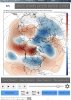
Deep SE folks are going to like the 0Z EPS as it, like the operational, shifted well SE on the cold and the mean surface low track as well as having ample qpf:
1. Like the operational, look how far SE the mean surface low is on the 0Z EPS:
View attachment 16418
2. Temperatures are significantly colder on the 0Z than the 12Z EPS with even much colder anomalies lurking a few hundred miles to the NW:View attachment 16419
3. QPF is quite significant in the deep SE:
View attachment 16420
It’s Definitely very classic looking for the SE for a winter storm, and a good one at that to, low developing on a old artic front and confluence acting to keep things suppressed by having high pressure stuck under and dominating/suppressing everything, we need keep trends stable with the 50/50 low or this storm could change for the worse
